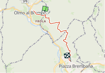
![](/images/other/stat-length.png)
![Tocht Te voet Olmo al Brembo - Sentiero 129A: Olmo al Brembo - Piazza Brembana - Photo](https://media.geolcdn.com/t/1900/400/760dd934-c1b1-47d2-ad99-ffb9346e04b9.jpeg&format=pjpeg&maxdim=2)
Sentiero 129A: Olmo al Brembo - Piazza Brembana
SityTrail - itinéraires balisés pédestres
Tous les sentiers balisés d’Europe GUIDE+
![Lengte](/images/other/stat-length.png)
![Max. hoogte](https://static1.geolcdn.com/siteimages/upload/files/1508320355ic_sort_altitude_max_24dp.png)
![Positief hoogteverschil](https://static1.geolcdn.com/siteimages/upload/files/1508320355ic_sort_den_pos_24dp.png)
![Km-Effort](/images/other/stat-length.png)
![Min. hoogte](https://static1.geolcdn.com/siteimages/upload/files/1508320355ic_sort_altitude_min_24dp.png)
![Negatief hoogteverschil](https://static1.geolcdn.com/siteimages/upload/files/1508320355ic_sort_den_neg_24dp.png)
![Boucle](https://static1.geolcdn.com/siteimages/upload/files/16400158638029165_repeat_loop_refresh_sync_direction_icon.png)
![Te voet](https://static1.geolcdn.com/sitytour/trail-icons/100.png)
2h01
Moeilijkheid : Gemakkelijk
![Scan deze QR-code om de tocht te openen in de SityTrail-applicatie](https://capi.geolives.com/qq0zvz2zws4bq2lad0pu/sitytour/trails/3124803/qr.png?size=200)
Gratisgps-wandelapplicatie
Over ons
Tocht Te voet van 4,9 km beschikbaar op Lombardije, Bergamo, Olmo al Brembo. Deze tocht wordt voorgesteld door SityTrail - itinéraires balisés pédestres.
Beschrijving
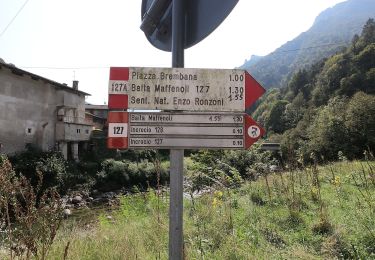
Arrivati a Olmo al Brembo percorrendo la SP1 in direzione Mezzoldo, subito dopo il ponte SP9 che porta a Cusio ed Averara si vede il Ponte Vecchio di Olmo di fronte al quale si trova la partenza del sentiero 129A. Il sentiero si presenta come una mulattiera che un tempo era la "Strada di Valle”, che prima della Priula, alla fine del Cinquecento, aprì il passaggio sotto la
Website: http://geoportale.caibergamo.it/it/sentiero/129A
Plaatsbepaling
Opmerkingen
Wandeltochten in de omgeving
![Tocht Te voet Lenna - Sentiero 269: Lenna (Cantone San Francesco) - Roncobello - Photo](https://media.geolcdn.com/t/375/260/a4fae432-50cb-44b4-9bda-feda9a2bd824.jpeg&format=jpg&maxdim=2)
![Te voet Te voet](https://static1.geolcdn.com/sitytour/trail-icons/100.png)
Te voet
![](/images/other/stat-length.png)
![](https://static1.geolcdn.com/siteimages/upload/files/16400158638029165_repeat_loop_refresh_sync_direction_icon.png)
![Tocht Te voet Moio de' Calvi - Sentiero 126: Moio de' Calvi - Monte Torcola - Photo](https://media.geolcdn.com/t/375/260/a66cadce-b960-421f-819b-1364f5662a4e.jpeg&format=jpg&maxdim=2)
![Te voet Te voet](https://static1.geolcdn.com/sitytour/trail-icons/100.png)
Te voet
![](/images/other/stat-length.png)
![](https://static1.geolcdn.com/siteimages/upload/files/16400158638029165_repeat_loop_refresh_sync_direction_icon.png)
![Tocht Te voet Piazza Brembana - Sentiero 123: Piazza Brembana - Roccolo di Calche - Photo](https://media.geolcdn.com/t/375/260/760dd934-c1b1-47d2-ad99-ffb9346e04b9.jpeg&format=jpg&maxdim=2)
![Te voet Te voet](https://static1.geolcdn.com/sitytour/trail-icons/100.png)
Te voet
![](/images/other/stat-length.png)
![](https://static1.geolcdn.com/siteimages/upload/files/16400158638029165_repeat_loop_refresh_sync_direction_icon.png)
![Tocht Te voet Olmo al Brembo - Sentiero 129: Olmo al Brembo - Roccolo di Calche - Photo](https://media.geolcdn.com/t/375/260/014ff2b6-1b3d-4584-a37f-8208c225d628.jpeg&format=jpg&maxdim=2)
![Te voet Te voet](https://static1.geolcdn.com/sitytour/trail-icons/100.png)
Te voet
![](/images/other/stat-length.png)
![](https://static1.geolcdn.com/siteimages/upload/files/16400158638029165_repeat_loop_refresh_sync_direction_icon.png)
![Tocht Te voet Olmo al Brembo - Sentiero 127: Cugno di Sotto (Olmo al Brembo) - Baita Maffenoli - Photo](https://media.geolcdn.com/t/375/260/014ff2b6-1b3d-4584-a37f-8208c225d628.jpeg&format=jpg&maxdim=2)
![Te voet Te voet](https://static1.geolcdn.com/sitytour/trail-icons/100.png)
Te voet
![](/images/other/stat-length.png)
![](https://static1.geolcdn.com/siteimages/upload/files/16400158638029165_repeat_loop_refresh_sync_direction_icon.png)
![Tocht Te voet Piazza Brembana - Sentiero 128: Piazza Brembana - Cespedosio - Photo](https://media.geolcdn.com/t/375/260/760dd934-c1b1-47d2-ad99-ffb9346e04b9.jpeg&format=jpg&maxdim=2)
![Te voet Te voet](https://static1.geolcdn.com/sitytour/trail-icons/100.png)
Te voet
![](/images/other/stat-length.png)
![](https://static1.geolcdn.com/siteimages/upload/files/16400158638029165_repeat_loop_refresh_sync_direction_icon.png)
![Tocht Te voet Piazza Brembana - Sentiero 127A: Piazza Brembana (loc. i Fondi) - Olmo al Brembo (fraz. Cugno) - Photo](https://media.geolcdn.com/t/375/260/9d67b535-4b05-4006-ba0e-37dc10f33dd2.jpeg&format=jpg&maxdim=2)
![Te voet Te voet](https://static1.geolcdn.com/sitytour/trail-icons/100.png)
Te voet
![](/images/other/stat-length.png)
![](https://static1.geolcdn.com/siteimages/upload/files/16400158638029165_repeat_loop_refresh_sync_direction_icon.png)
![Tocht Te voet Valnegra - Sentiero 119: Valnegra - Monte Torcola - Forcolino di Torcola - Photo](https://media.geolcdn.com/t/375/260/0b53ae85-4fb7-490e-88e3-eb051f183083.jpeg&format=jpg&maxdim=2)
![Te voet Te voet](https://static1.geolcdn.com/sitytour/trail-icons/100.png)
Te voet
![](/images/other/stat-length.png)
![](https://static1.geolcdn.com/siteimages/upload/files/16400158638029165_repeat_loop_refresh_sync_direction_icon.png)
![Tocht Te voet Cassiglio - Sentiero delle Orobie Occidentali - Tappa 1 - Photo](https://media.geolcdn.com/t/375/260/09d510e2-f6ad-4996-b599-3605221ca888.jpeg&format=jpg&maxdim=2)
![Te voet Te voet](https://static1.geolcdn.com/sitytour/trail-icons/100.png)
Te voet
![](/images/other/stat-length.png)
![](https://static1.geolcdn.com/siteimages/upload/files/16400158638029165_repeat_loop_refresh_sync_direction_icon.png)