![](/images/other/stat-length.png)
![Tocht Te voet Montfaucon - Boucle de Nacra - Photo](https://media.geolcdn.com/t/1900/400/754b99f9-55b9-4375-839c-408b044dfd0e.jpeg&format=pjpeg&maxdim=2)
Boucle de Nacra
SityTrail - itinéraires balisés pédestres
Tous les sentiers balisés d’Europe GUIDE+
![Lengte](/images/other/stat-length.png)
Lengte
3 km
![Max. hoogte](https://static1.geolcdn.com/siteimages/upload/files/1508320355ic_sort_altitude_max_24dp.png)
Max. hoogte
503 m
![Positief hoogteverschil](https://static1.geolcdn.com/siteimages/upload/files/1508320355ic_sort_den_pos_24dp.png)
Positief hoogteverschil
104 m
![Km-Effort](/images/other/stat-length.png)
Km-Effort
4,4 km
![Min. hoogte](https://static1.geolcdn.com/siteimages/upload/files/1508320355ic_sort_altitude_min_24dp.png)
Min. hoogte
394 m
![Negatief hoogteverschil](https://static1.geolcdn.com/siteimages/upload/files/1508320355ic_sort_den_neg_24dp.png)
Negatief hoogteverschil
103 m
![Boucle](https://static1.geolcdn.com/siteimages/upload/files/16400158638029165_repeat_loop_refresh_sync_direction_icon.png)
Boucle
Ja
Markering
Datum van aanmaak :
2022-02-15 19:30:37.627
Laatste wijziging :
2022-03-03 00:12:38.411
![Te voet](https://static1.geolcdn.com/sitytour/trail-icons/100.png)
1h00
Moeilijkheid : Gemakkelijk
![Scan deze QR-code om de tocht te openen in de SityTrail-applicatie](https://capi.geolives.com/qq0zvz2zws4bq2lad0pu/sitytour/trails/3124774/qr.png?size=200)
Gratisgps-wandelapplicatie
Over ons
Tocht Te voet van 3 km beschikbaar op Bourgondië-Franche-Comté, Doubs, Montfaucon. Deze tocht wordt voorgesteld door SityTrail - itinéraires balisés pédestres.
Beschrijving
Trail created by Grand Besançon.
Plaatsbepaling
Land:
France
Regio :
Bourgondië-Franche-Comté
Departement/Provincie :
Doubs
Gemeente :
Montfaucon
Locatie:
Unknown
Vertrek:(Dec)
Vertrek:(UTM)
278753 ; 5235326 (32T) N.
Opmerkingen
Wandeltochten in de omgeving
![Tocht Stappen Montfaucon - Du chateau au fort de Monfaucon - Photo](https://media.geolcdn.com/t/375/260/ext.jpg?maxdim=2&url=https%3A%2F%2Fservices.sitytrail.com%2FGeolivesWS%2FDownloadMedia.ashx%3FTrailID%3D705744%26Media%3Dfix__20170226154846.jpg)
![Stappen Stappen](https://static1.geolcdn.com/sitytour/trail-icons/101.png)
Du chateau au fort de Monfaucon
Stappen
Gemakkelijk
(1)
Montfaucon,
Bourgondië-Franche-Comté,
Doubs,
France
![](/images/other/stat-length.png)
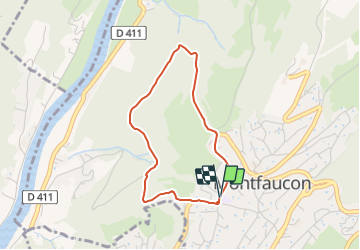
6,9 km | 9,3 km-effort
1h 55min
![](https://static1.geolcdn.com/siteimages/upload/files/16400158638029165_repeat_loop_refresh_sync_direction_icon.png)
Ja
![Tocht Stappen Besançon - Colline de Besançon 29-08-2020 - Photo](https://media.geolcdn.com/t/375/260/1e155548-d400-46d3-8b28-207c9933a379.jpg&format=jpg&maxdim=2)
![Stappen Stappen](https://static1.geolcdn.com/sitytour/trail-icons/101.png)
Colline de Besançon 29-08-2020
Stappen
Medium
(1)
Besançon,
Bourgondië-Franche-Comté,
Doubs,
France
![](/images/other/stat-length.png)
13,4 km | 17,7 km-effort
2h 46min
![](https://static1.geolcdn.com/siteimages/upload/files/16400158638029165_repeat_loop_refresh_sync_direction_icon.png)
Ja
![Tocht Stappen Fontain - fontain - fort de Fontain - forêt de Fontain - Photo](https://media.geolcdn.com/t/375/260/dda8671d-de1b-4872-afba-e5376a2d57f0.jpg&format=jpg&maxdim=2)
![Stappen Stappen](https://static1.geolcdn.com/sitytour/trail-icons/101.png)
fontain - fort de Fontain - forêt de Fontain
Stappen
Heel gemakkelijk
(2)
Fontain,
Bourgondië-Franche-Comté,
Doubs,
France
![](/images/other/stat-length.png)
11,9 km | 15,2 km-effort
3h 11min
![](https://static1.geolcdn.com/siteimages/upload/files/16400158638029165_repeat_loop_refresh_sync_direction_icon.png)
Ja
![Tocht Te voet Mamirolle - Sentier du Bois de la Fougère - Photo](https://media.geolcdn.com/t/375/260/a8a8f146-f198-41be-852b-9ac1789ecd72.jpeg&format=jpg&maxdim=2)
![Te voet Te voet](https://static1.geolcdn.com/sitytour/trail-icons/100.png)
Sentier du Bois de la Fougère
Te voet
Gemakkelijk
Mamirolle,
Bourgondië-Franche-Comté,
Doubs,
France
![](/images/other/stat-length.png)
7,3 km | 8,7 km-effort
1h 58min
![](https://static1.geolcdn.com/siteimages/upload/files/16400158638029165_repeat_loop_refresh_sync_direction_icon.png)
Ja
![Tocht Te voet Saône - Sentier des Essarts - Photo](https://media.geolcdn.com/t/375/260/bda44002-ccb3-4d91-bd01-33fbc5477f0c.jpeg&format=jpg&maxdim=2)
![Te voet Te voet](https://static1.geolcdn.com/sitytour/trail-icons/100.png)
Sentier des Essarts
Te voet
Gemakkelijk
Saône,
Bourgondië-Franche-Comté,
Doubs,
France
![](/images/other/stat-length.png)
6,9 km | 8,1 km-effort
1h 50min
![](https://static1.geolcdn.com/siteimages/upload/files/16400158638029165_repeat_loop_refresh_sync_direction_icon.png)
Ja
![Tocht Te voet Montfaucon - Sentier des Falaises et du château - Photo](https://media.geolcdn.com/t/375/260/5325d98d-322b-4b71-b21b-224d670c2150.jpeg&format=jpg&maxdim=2)
![Te voet Te voet](https://static1.geolcdn.com/sitytour/trail-icons/100.png)
Sentier des Falaises et du château
Te voet
Gemakkelijk
Montfaucon,
Bourgondië-Franche-Comté,
Doubs,
France
![](/images/other/stat-length.png)
5 km | 7,1 km-effort
1h 37min
![](https://static1.geolcdn.com/siteimages/upload/files/16400158638029165_repeat_loop_refresh_sync_direction_icon.png)
Ja
![Tocht Te voet Montfaucon - Sentier du Fort et des Batteries - Photo](https://media.geolcdn.com/t/375/260/465eae89-7ad3-4616-8710-419d54be2030.jpeg&format=jpg&maxdim=2)
![Te voet Te voet](https://static1.geolcdn.com/sitytour/trail-icons/100.png)
Sentier du Fort et des Batteries
Te voet
Gemakkelijk
Montfaucon,
Bourgondië-Franche-Comté,
Doubs,
France
![](/images/other/stat-length.png)
6,6 km | 8,7 km-effort
1h 58min
![](https://static1.geolcdn.com/siteimages/upload/files/16400158638029165_repeat_loop_refresh_sync_direction_icon.png)
Ja
![Tocht Te voet Fontain - Grande Boucle de Fontain - Photo](https://media.geolcdn.com/t/375/260/f1d37a4d-b9db-4571-aaef-737a004f40e0.jpeg&format=jpg&maxdim=2)
![Te voet Te voet](https://static1.geolcdn.com/sitytour/trail-icons/100.png)
Grande Boucle de Fontain
Te voet
Gemakkelijk
(1)
Fontain,
Bourgondië-Franche-Comté,
Doubs,
France
![](/images/other/stat-length.png)
10 km | 13,2 km-effort
2h 59min
![](https://static1.geolcdn.com/siteimages/upload/files/16400158638029165_repeat_loop_refresh_sync_direction_icon.png)
Ja
![Tocht Te voet Morre - Sentier des Buis - Photo](https://media.geolcdn.com/t/375/260/00c23f5f-41e9-4001-afe9-fc138b72cbaf.jpeg&format=jpg&maxdim=2)
![Te voet Te voet](https://static1.geolcdn.com/sitytour/trail-icons/100.png)
Sentier des Buis
Te voet
Gemakkelijk
Morre,
Bourgondië-Franche-Comté,
Doubs,
France
![](/images/other/stat-length.png)
6,4 km | 9 km-effort
2h 2min
![](https://static1.geolcdn.com/siteimages/upload/files/16400158638029165_repeat_loop_refresh_sync_direction_icon.png)
Ja