![](/images/other/stat-length.png)
![Tocht Te voet Pléchâtel - Circuit de la Croix des Jeunes - Photo](https://media.geolcdn.com/t/1900/400/9e8b4b4f-d301-4624-a79a-f0749db2dfcc.jpeg&format=pjpeg&maxdim=2)
Circuit de la Croix des Jeunes
SityTrail - itinéraires balisés pédestres
Tous les sentiers balisés d’Europe GUIDE+
![Lengte](/images/other/stat-length.png)
Lengte
4,1 km
![Max. hoogte](https://static1.geolcdn.com/siteimages/upload/files/1508320355ic_sort_altitude_max_24dp.png)
Max. hoogte
71 m
![Positief hoogteverschil](https://static1.geolcdn.com/siteimages/upload/files/1508320355ic_sort_den_pos_24dp.png)
Positief hoogteverschil
87 m
![Km-Effort](/images/other/stat-length.png)
Km-Effort
5,2 km
![Min. hoogte](https://static1.geolcdn.com/siteimages/upload/files/1508320355ic_sort_altitude_min_24dp.png)
Min. hoogte
16 m
![Negatief hoogteverschil](https://static1.geolcdn.com/siteimages/upload/files/1508320355ic_sort_den_neg_24dp.png)
Negatief hoogteverschil
63 m
![Boucle](https://static1.geolcdn.com/siteimages/upload/files/16400158638029165_repeat_loop_refresh_sync_direction_icon.png)
Boucle
Neen
Markering
Datum van aanmaak :
2022-02-15 19:23:59.98
Laatste wijziging :
2022-03-02 23:52:58.381
![Te voet](https://static1.geolcdn.com/sitytour/trail-icons/100.png)
1h11
Moeilijkheid : Gemakkelijk
![Scan deze QR-code om de tocht te openen in de SityTrail-applicatie](https://capi.geolives.com/qq0zvz2zws4bq2lad0pu/sitytour/trails/3124675/qr.png?size=200)
Gratisgps-wandelapplicatie
Over ons
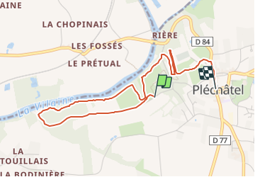
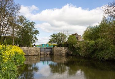
Tocht Te voet van 4,1 km beschikbaar op Bretagne, Ille-et-Vilaine, Pléchâtel. Deze tocht wordt voorgesteld door SityTrail - itinéraires balisés pédestres.
Beschrijving
Trail created by Commune de Pléchâtel.
Website: https://www.plechatel.fr/circuit-de-la-croix-des-jeunes-2/
Plaatsbepaling
Land:
France
Regio :
Bretagne
Departement/Provincie :
Ille-et-Vilaine
Gemeente :
Pléchâtel
Locatie:
Unknown
Vertrek:(Dec)
Vertrek:(UTM)
592877 ; 5305278 (30T) N.
Opmerkingen
Wandeltochten in de omgeving
![Tocht Te voet Pléchâtel - Circuit de Mainténiac - Photo](https://media.geolcdn.com/t/375/260/7fb5ae18-f1db-43e6-a6e1-b87dc82d549d.jpeg&format=jpg&maxdim=2)
![Te voet Te voet](https://static1.geolcdn.com/sitytour/trail-icons/100.png)
Circuit de Mainténiac
Te voet
Gemakkelijk
Pléchâtel,
Bretagne,
Ille-et-Vilaine,
France
![](/images/other/stat-length.png)
7,1 km | 8,5 km-effort
1h 56min
![](https://static1.geolcdn.com/siteimages/upload/files/16400158638029165_repeat_loop_refresh_sync_direction_icon.png)
Ja
![Tocht Te voet Bourg-des-Comptes - Circuit des Biches - Photo](https://media.geolcdn.com/t/375/260/5a6882f1-47ea-4e81-ab0e-66797e6d831a.jpeg&format=jpg&maxdim=2)
![Te voet Te voet](https://static1.geolcdn.com/sitytour/trail-icons/100.png)
Circuit des Biches
Te voet
Gemakkelijk
Bourg-des-Comptes,
Bretagne,
Ille-et-Vilaine,
France
![](/images/other/stat-length.png)
9,3 km | 11,5 km-effort
2h 36min
![](https://static1.geolcdn.com/siteimages/upload/files/16400158638029165_repeat_loop_refresh_sync_direction_icon.png)
Ja
![Tocht Te voet Saint-Senoux - Circuit de la Levée - Photo](https://media.geolcdn.com/t/375/260/9e8b4b4f-d301-4624-a79a-f0749db2dfcc.jpeg&format=jpg&maxdim=2)
![Te voet Te voet](https://static1.geolcdn.com/sitytour/trail-icons/100.png)
Circuit de la Levée
Te voet
Gemakkelijk
Saint-Senoux,
Bretagne,
Ille-et-Vilaine,
France
![](/images/other/stat-length.png)
10,1 km | 12,5 km-effort
2h 50min
![](https://static1.geolcdn.com/siteimages/upload/files/16400158638029165_repeat_loop_refresh_sync_direction_icon.png)
Ja
![Tocht Te voet Saint-Senoux - circuit de Cambertu - Photo](https://media.geolcdn.com/t/375/260/93b56c7a-45ee-41ec-9e8c-bf78f2aa3c2d.jpeg&format=jpg&maxdim=2)
![Te voet Te voet](https://static1.geolcdn.com/sitytour/trail-icons/100.png)
circuit de Cambertu
Te voet
Gemakkelijk
Saint-Senoux,
Bretagne,
Ille-et-Vilaine,
France
![](/images/other/stat-length.png)
3,1 km | 4,1 km-effort
56min
![](https://static1.geolcdn.com/siteimages/upload/files/16400158638029165_repeat_loop_refresh_sync_direction_icon.png)
Ja
![Tocht Te voet Saint-Senoux - Circuit des Pervenches - Photo](https://media.geolcdn.com/t/375/260/93b56c7a-45ee-41ec-9e8c-bf78f2aa3c2d.jpeg&format=jpg&maxdim=2)
![Te voet Te voet](https://static1.geolcdn.com/sitytour/trail-icons/100.png)
Circuit des Pervenches
Te voet
Gemakkelijk
Saint-Senoux,
Bretagne,
Ille-et-Vilaine,
France
![](/images/other/stat-length.png)
5,5 km | 7,3 km-effort
1h 40min
![](https://static1.geolcdn.com/siteimages/upload/files/16400158638029165_repeat_loop_refresh_sync_direction_icon.png)
Ja
![Tocht Te voet Saint-Senoux - Circuit de la Trotinais - Photo](https://media.geolcdn.com/t/375/260/467b66a9-2355-44bb-b47d-644a46c89128.jpeg&format=jpg&maxdim=2)
![Te voet Te voet](https://static1.geolcdn.com/sitytour/trail-icons/100.png)
Circuit de la Trotinais
Te voet
Gemakkelijk
Saint-Senoux,
Bretagne,
Ille-et-Vilaine,
France
![](/images/other/stat-length.png)
12,3 km | 15,8 km-effort
3h 35min
![](https://static1.geolcdn.com/siteimages/upload/files/16400158638029165_repeat_loop_refresh_sync_direction_icon.png)
Ja
![Tocht Te voet Saint-Senoux - Circuit de Montserrat - Photo](https://media.geolcdn.com/t/375/260/7c59d14c-71e7-4b3e-a7a6-7b64af8289dc.jpeg&format=jpg&maxdim=2)
![Te voet Te voet](https://static1.geolcdn.com/sitytour/trail-icons/100.png)
Circuit de Montserrat
Te voet
Gemakkelijk
(1)
Saint-Senoux,
Bretagne,
Ille-et-Vilaine,
France
![](/images/other/stat-length.png)
13,6 km | 17,7 km-effort
4h 1min
![](https://static1.geolcdn.com/siteimages/upload/files/16400158638029165_repeat_loop_refresh_sync_direction_icon.png)
Ja
![Tocht Stappen Saint-Senoux - Saint Senoux - Photo](https://media.geolcdn.com/t/375/260/77674719-b9f4-4499-9d32-8602bcc87a45.jpg&format=jpg&maxdim=2)
![Stappen Stappen](https://static1.geolcdn.com/sitytour/trail-icons/101.png)
Saint Senoux
Stappen
Medium
Saint-Senoux,
Bretagne,
Ille-et-Vilaine,
France
![](/images/other/stat-length.png)
15,7 km | 20 km-effort
3h 46min
![](https://static1.geolcdn.com/siteimages/upload/files/16400158638029165_repeat_loop_refresh_sync_direction_icon.png)
Ja
![Tocht Stappen Saint-Senoux - La Trotinais - Saint Senoux - Photo](https://media.geolcdn.com/t/375/260/ext.jpg?maxdim=2&url=https%3A%2F%2Fservices.sitytrail.com%2FGeolivesWS%2FDownloadMedia.ashx%3FTrailID%3D317849%26Media%3D17227_3.jpg)
![Stappen Stappen](https://static1.geolcdn.com/sitytour/trail-icons/101.png)
La Trotinais - Saint Senoux
Stappen
Medium
Saint-Senoux,
Bretagne,
Ille-et-Vilaine,
France
![](/images/other/stat-length.png)
12,1 km | 15,6 km-effort
3h 30min
![](https://static1.geolcdn.com/siteimages/upload/files/16400158638029165_repeat_loop_refresh_sync_direction_icon.png)
Ja