![](/images/other/stat-length.png)
![Tocht Te voet Arles - Balade au cœur des Marais du Verdier - Photo](https://media.geolcdn.com/t/1900/400/f491de79-e548-46d6-b1af-80132bcb96c1.jpeg&format=pjpeg&maxdim=2)
Balade au cœur des Marais du Verdier
SityTrail - itinéraires balisés pédestres
Tous les sentiers balisés d’Europe GUIDE+
![Lengte](/images/other/stat-length.png)
Lengte
7,1 km
![Max. hoogte](https://static1.geolcdn.com/siteimages/upload/files/1508320355ic_sort_altitude_max_24dp.png)
Max. hoogte
3 m
![Positief hoogteverschil](https://static1.geolcdn.com/siteimages/upload/files/1508320355ic_sort_den_pos_24dp.png)
Positief hoogteverschil
12 m
![Km-Effort](/images/other/stat-length.png)
Km-Effort
7,3 km
![Min. hoogte](https://static1.geolcdn.com/siteimages/upload/files/1508320355ic_sort_altitude_min_24dp.png)
Min. hoogte
-3 m
![Negatief hoogteverschil](https://static1.geolcdn.com/siteimages/upload/files/1508320355ic_sort_den_neg_24dp.png)
Negatief hoogteverschil
12 m
![Boucle](https://static1.geolcdn.com/siteimages/upload/files/16400158638029165_repeat_loop_refresh_sync_direction_icon.png)
Boucle
Ja
Markering
Datum van aanmaak :
2022-02-15 19:17:48.826
Laatste wijziging :
2022-03-02 23:43:22.667
![Te voet](https://static1.geolcdn.com/sitytour/trail-icons/100.png)
1h39
Moeilijkheid : Gemakkelijk
![Scan deze QR-code om de tocht te openen in de SityTrail-applicatie](https://capi.geolives.com/qq0zvz2zws4bq2lad0pu/sitytour/trails/3124559/qr.png?size=200)
Gratisgps-wandelapplicatie
Over ons
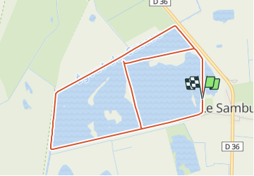
Tocht Te voet van 7,1 km beschikbaar op Provence-Alpes-Côte d'Azur, Bouches-du-Rhône, Arles. Deze tocht wordt voorgesteld door SityTrail - itinéraires balisés pédestres.
Beschrijving
Trail created by Département des Bouches-du-Rhône.
Website: https://www.cheminsdesparcs.fr/pedestre/balade-au-coeur-des-marais-du-verdier/
Plaatsbepaling
Land:
France
Regio :
Provence-Alpes-Côte d'Azur
Departement/Provincie :
Bouches-du-Rhône
Gemeente :
Arles
Locatie:
Unknown
Vertrek:(Dec)
Vertrek:(UTM)
637597 ; 4820593 (31T) N.
Opmerkingen
Wandeltochten in de omgeving
![Tocht Hybride fiets Arles - 13 -Via Rhôna de Mas Thibert à Port Saint Louis du Rhône - Photo](https://media.geolcdn.com/t/375/260/c1a8e516-fdcc-4f3e-ba9f-8ef0c9e81ff2.jpg&format=jpg&maxdim=2)
![Hybride fiets Hybride fiets](https://static1.geolcdn.com/sitytour/trail-icons/203.png)
13 -Via Rhôna de Mas Thibert à Port Saint Louis du Rhône
Hybride fiets
Gemakkelijk
Arles,
Provence-Alpes-Côte d'Azur,
Bouches-du-Rhône,
France
![](/images/other/stat-length.png)
61 km | 63 km-effort
5h 30min
![](https://static1.geolcdn.com/siteimages/upload/files/16400158638029165_repeat_loop_refresh_sync_direction_icon.png)
Ja
![Tocht Fietstoerisme Arles - Via Rhôna - Photo](https://media.geolcdn.com/t/375/260/ext.jpg?maxdim=2&url=https%3A%2F%2Fstatic1.geolcdn.com%2Fsiteimages%2Fupload%2Ffiles%2F1524743154velo.jpg)
![Fietstoerisme Fietstoerisme](https://static1.geolcdn.com/sitytour/trail-icons/204.png)
Via Rhôna
Fietstoerisme
Gemakkelijk
Arles,
Provence-Alpes-Côte d'Azur,
Bouches-du-Rhône,
France
![](/images/other/stat-length.png)
18,4 km | 19,3 km-effort
Onbekend
![](https://static1.geolcdn.com/siteimages/upload/files/16400158638029165_repeat_loop_refresh_sync_direction_icon.png)
Neen
![Tocht Stappen Arles - port st louis - Photo](https://media.geolcdn.com/t/375/260/ext.jpg?maxdim=2&url=https%3A%2F%2Fstatic1.geolcdn.com%2Fsiteimages%2Fupload%2Ffiles%2F1553511878bg_sport_marche.png)
![Stappen Stappen](https://static1.geolcdn.com/sitytour/trail-icons/101.png)
port st louis
Stappen
Zeer moeilijk
Arles,
Provence-Alpes-Côte d'Azur,
Bouches-du-Rhône,
France
![](/images/other/stat-length.png)
62 km | 64 km-effort
17h 30min
![](https://static1.geolcdn.com/siteimages/upload/files/16400158638029165_repeat_loop_refresh_sync_direction_icon.png)
Ja
![Tocht Stappen Arles - 20220421 La capeliere - Photo](https://media.geolcdn.com/t/375/260/ext.jpg?maxdim=2&url=https%3A%2F%2Fstatic1.geolcdn.com%2Fsiteimages%2Fupload%2Ffiles%2F1553511878bg_sport_marche.png)
![Stappen Stappen](https://static1.geolcdn.com/sitytour/trail-icons/101.png)
20220421 La capeliere
Stappen
Gemakkelijk
Arles,
Provence-Alpes-Côte d'Azur,
Bouches-du-Rhône,
France
![](/images/other/stat-length.png)
1,7 km | 1,7 km-effort
33min
![](https://static1.geolcdn.com/siteimages/upload/files/16400158638029165_repeat_loop_refresh_sync_direction_icon.png)
Ja
![Tocht Stappen Arles - sentier de l'etourneau - Photo](https://media.geolcdn.com/t/375/260/ext.jpg?maxdim=2&url=https%3A%2F%2Fstatic1.geolcdn.com%2Fsiteimages%2Fupload%2Ffiles%2F1553511878bg_sport_marche.png)
![Stappen Stappen](https://static1.geolcdn.com/sitytour/trail-icons/101.png)
sentier de l'etourneau
Stappen
Heel gemakkelijk
Arles,
Provence-Alpes-Côte d'Azur,
Bouches-du-Rhône,
France
![](/images/other/stat-length.png)
2,5 km | 2,6 km-effort
35min
![](https://static1.geolcdn.com/siteimages/upload/files/16400158638029165_repeat_loop_refresh_sync_direction_icon.png)
Ja