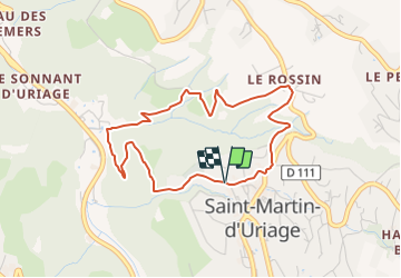
![](/images/other/stat-length.png)
![Tocht Te voet Saint-Martin-d'Uriage - Circuit des Vignasses - Photo](https://media.geolcdn.com/t/1900/400/a9275979-9507-4371-af10-ddb930f092f2.jpeg&format=pjpeg&maxdim=2)
Circuit des Vignasses
SityTrail - itinéraires balisés pédestres
Tous les sentiers balisés d’Europe GUIDE+
![Lengte](/images/other/stat-length.png)
![Max. hoogte](https://static1.geolcdn.com/siteimages/upload/files/1508320355ic_sort_altitude_max_24dp.png)
![Positief hoogteverschil](https://static1.geolcdn.com/siteimages/upload/files/1508320355ic_sort_den_pos_24dp.png)
![Km-Effort](/images/other/stat-length.png)
![Min. hoogte](https://static1.geolcdn.com/siteimages/upload/files/1508320355ic_sort_altitude_min_24dp.png)
![Negatief hoogteverschil](https://static1.geolcdn.com/siteimages/upload/files/1508320355ic_sort_den_neg_24dp.png)
![Boucle](https://static1.geolcdn.com/siteimages/upload/files/16400158638029165_repeat_loop_refresh_sync_direction_icon.png)
![Te voet](https://static1.geolcdn.com/sitytour/trail-icons/100.png)
1h40
Moeilijkheid : Gemakkelijk
![Scan deze QR-code om de tocht te openen in de SityTrail-applicatie](https://capi.geolives.com/qq0zvz2zws4bq2lad0pu/sitytour/trails/3123510/qr.png?size=200)
Gratisgps-wandelapplicatie
Over ons
Tocht Te voet van 4,1 km beschikbaar op Auvergne-Rhône-Alpes, Isère, Saint-Martin-d'Uriage. Deze tocht wordt voorgesteld door SityTrail - itinéraires balisés pédestres.
Beschrijving
Trail created by Convention entre la commune de Saint-Martin-d’Uriage et l'association “Les Sentiers de Saint Martin d'Uriage”.
Symbol: blue bar on white ground
Website: https://www.uriage-les-bains.com/docs/circuit-des-vignasses.pdf
Plaatsbepaling
Opmerkingen
Wandeltochten in de omgeving
![Tocht Ski randonnée Chamrousse - col de la petite vaudaine - Photo](https://media.geolcdn.com/t/375/260/e327fe41-90ef-426f-99b9-61a7be1ec455.jpg&format=jpg&maxdim=2)
![Ski randonnée Ski randonnée](https://static1.geolcdn.com/sitytour/trail-icons/503.png)
Ski randonnée
![](/images/other/stat-length.png)
![](https://static1.geolcdn.com/siteimages/upload/files/16400158638029165_repeat_loop_refresh_sync_direction_icon.png)
![Tocht Te voet Saint-Martin-d'Uriage - Circuit des Curistes - Photo](https://media.geolcdn.com/t/375/260/884736af-6d5e-4498-9816-404871d42486.jpeg&format=jpg&maxdim=2)
![Te voet Te voet](https://static1.geolcdn.com/sitytour/trail-icons/100.png)
Te voet
![](/images/other/stat-length.png)
![](https://static1.geolcdn.com/siteimages/upload/files/16400158638029165_repeat_loop_refresh_sync_direction_icon.png)
![Tocht Te voet Saint-Martin-d'Uriage - Circuit des Crêtes - Photo](https://media.geolcdn.com/t/375/260/a077f9fa-48e4-483f-a273-f9f858afd6d0.jpeg&format=jpg&maxdim=2)
![Te voet Te voet](https://static1.geolcdn.com/sitytour/trail-icons/100.png)
Te voet
![](/images/other/stat-length.png)
![](https://static1.geolcdn.com/siteimages/upload/files/16400158638029165_repeat_loop_refresh_sync_direction_icon.png)
![Tocht Te voet Saint-Martin-d'Uriage - Circuit du Bit - Photo](https://media.geolcdn.com/t/375/260/2fa5dbdf-0fcb-48b8-a2a0-bdb0f129de25.jpeg&format=jpg&maxdim=2)
![Te voet Te voet](https://static1.geolcdn.com/sitytour/trail-icons/100.png)
Te voet
![](/images/other/stat-length.png)
![](https://static1.geolcdn.com/siteimages/upload/files/16400158638029165_repeat_loop_refresh_sync_direction_icon.png)
![Tocht Te voet Saint-Martin-d'Uriage - Balcon de Combeloup - Photo](https://media.geolcdn.com/t/375/260/67f211a9-4659-4ac8-8551-19ac88e52f68.jpeg&format=jpg&maxdim=2)
![Te voet Te voet](https://static1.geolcdn.com/sitytour/trail-icons/100.png)
Te voet
![](/images/other/stat-length.png)
![](https://static1.geolcdn.com/siteimages/upload/files/16400158638029165_repeat_loop_refresh_sync_direction_icon.png)
![Tocht Te voet Gières - De Gières au col du Gourlu - Photo](https://media.geolcdn.com/t/375/260/b782ea79-2f14-452c-9af6-76dad2fec664.jpeg&format=jpg&maxdim=2)
![Te voet Te voet](https://static1.geolcdn.com/sitytour/trail-icons/100.png)
Te voet
![](/images/other/stat-length.png)
![](https://static1.geolcdn.com/siteimages/upload/files/16400158638029165_repeat_loop_refresh_sync_direction_icon.png)
![Tocht Stappen Chamrousse - lacs Robert - Photo](https://media.geolcdn.com/t/375/260/ext.jpg?maxdim=2&url=https%3A%2F%2Fstatic1.geolcdn.com%2Fsiteimages%2Fupload%2Ffiles%2F1553511878bg_sport_marche.png)
![Stappen Stappen](https://static1.geolcdn.com/sitytour/trail-icons/101.png)
Stappen
![](/images/other/stat-length.png)
![](https://static1.geolcdn.com/siteimages/upload/files/16400158638029165_repeat_loop_refresh_sync_direction_icon.png)
![Tocht Stappen Chamrousse - la grande moucherolle et la petite - Photo](https://media.geolcdn.com/t/375/260/e3dde858-ba24-405b-860c-373322d4b17f.jpg&format=jpg&maxdim=2)
![Stappen Stappen](https://static1.geolcdn.com/sitytour/trail-icons/101.png)
Stappen
![](/images/other/stat-length.png)
![](https://static1.geolcdn.com/siteimages/upload/files/16400158638029165_repeat_loop_refresh_sync_direction_icon.png)
![Tocht Stappen Saint-Martin-d'Uriage - Les Seiglières. Circuit des Gardes n°9 raccourci à 8 km - Photo](https://media.geolcdn.com/t/375/260/e86aee80-f13d-4d4a-be38-285e5f19658e.jpg&format=jpg&maxdim=2)
![Stappen Stappen](https://static1.geolcdn.com/sitytour/trail-icons/101.png)
Stappen
![](/images/other/stat-length.png)
![](https://static1.geolcdn.com/siteimages/upload/files/16400158638029165_repeat_loop_refresh_sync_direction_icon.png)