![](/images/other/stat-length.png)
![Tocht Te voet Rambluzin-et-Benoite-Vaux - Le Vallon Béni - Photo](https://media.geolcdn.com/t/1900/400/ext.pjpeg?maxdim=2&url=https%3A%2F%2Fstatic1.geolcdn.com%2Fsiteimages%2Fupload%2Ffiles%2F1545311037marcheuse_200dpi.jpg)
Le Vallon Béni
SityTrail - itinéraires balisés pédestres
Tous les sentiers balisés d’Europe GUIDE+
![Lengte](/images/other/stat-length.png)
Lengte
12 km
![Max. hoogte](https://static1.geolcdn.com/siteimages/upload/files/1508320355ic_sort_altitude_max_24dp.png)
Max. hoogte
353 m
![Positief hoogteverschil](https://static1.geolcdn.com/siteimages/upload/files/1508320355ic_sort_den_pos_24dp.png)
Positief hoogteverschil
276 m
![Km-Effort](/images/other/stat-length.png)
Km-Effort
15,6 km
![Min. hoogte](https://static1.geolcdn.com/siteimages/upload/files/1508320355ic_sort_altitude_min_24dp.png)
Min. hoogte
248 m
![Negatief hoogteverschil](https://static1.geolcdn.com/siteimages/upload/files/1508320355ic_sort_den_neg_24dp.png)
Negatief hoogteverschil
274 m
![Boucle](https://static1.geolcdn.com/siteimages/upload/files/16400158638029165_repeat_loop_refresh_sync_direction_icon.png)
Boucle
Ja
Markering
Datum van aanmaak :
2022-02-15 18:16:04.437
Laatste wijziging :
2022-03-02 20:42:51.047
![Te voet](https://static1.geolcdn.com/sitytour/trail-icons/100.png)
3h33
Moeilijkheid : Gemakkelijk
![Scan deze QR-code om de tocht te openen in de SityTrail-applicatie](https://capi.geolives.com/qq0zvz2zws4bq2lad0pu/sitytour/trails/3123483/qr.png?size=200)
Gratisgps-wandelapplicatie
Over ons
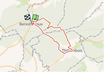
Tocht Te voet van 12 km beschikbaar op Grand Est, Meuse, Rambluzin-et-Benoite-Vaux. Deze tocht wordt voorgesteld door SityTrail - itinéraires balisés pédestres.
Beschrijving
Trail created by Pays de Verdin.
Website: http://www.pays-de-verdun.fr/medias/_documents/randonnee/rando-pays-verdun-14-benoite-vaux-vallon-beni.pdf
Plaatsbepaling
Land:
France
Regio :
Grand Est
Departement/Provincie :
Meuse
Gemeente :
Rambluzin-et-Benoite-Vaux
Locatie:
Unknown
Vertrek:(Dec)
Vertrek:(UTM)
672048 ; 5427596 (31U) N.
Opmerkingen
Wandeltochten in de omgeving
![Tocht Fiets Les Trois-Domaines - Vallée de la Meuse et Vent des Forêts - Issoncourt - Photo](https://media.geolcdn.com/t/375/260/ext.jpg?maxdim=2&url=https%3A%2F%2Fservices.sitytrail.com%2FGeolivesWS%2FDownloadMedia.ashx%3FTrailID%3D112037%26Media%3D9556_5.jpg)
![Fiets Fiets](https://static1.geolcdn.com/sitytour/trail-icons/200.png)
Vallée de la Meuse et Vent des Forêts - Issoncourt
Fiets
Medium
Les Trois-Domaines,
Grand Est,
Meuse,
France
![](/images/other/stat-length.png)
49 km | 57 km-effort
3h 0min
![](https://static1.geolcdn.com/siteimages/upload/files/16400158638029165_repeat_loop_refresh_sync_direction_icon.png)
Ja
![Tocht Stappen Lahaymeix - big tour vent des forets - 38 km.kml - Photo](https://media.geolcdn.com/t/375/260/ext.jpg?maxdim=2&url=https%3A%2F%2Fstatic1.geolcdn.com%2Fsiteimages%2Fupload%2Ffiles%2F1553511878bg_sport_marche.png)
![Stappen Stappen](https://static1.geolcdn.com/sitytour/trail-icons/101.png)
big tour vent des forets - 38 km.kml
Stappen
Zeer moeilijk
Lahaymeix,
Grand Est,
Meuse,
France
![](/images/other/stat-length.png)
38 km | 47 km-effort
10h 8min
![](https://static1.geolcdn.com/siteimages/upload/files/16400158638029165_repeat_loop_refresh_sync_direction_icon.png)
Ja
![Tocht Stappen Lahaymeix - Vent des Forêts, Circuit de Louvent - Photo](https://media.geolcdn.com/t/375/260/ext.jpg?maxdim=2&url=https%3A%2F%2Fstatic1.geolcdn.com%2Fsiteimages%2Fupload%2Ffiles%2F1553511878bg_sport_marche.png)
![Stappen Stappen](https://static1.geolcdn.com/sitytour/trail-icons/101.png)
Vent des Forêts, Circuit de Louvent
Stappen
Moeilijk
Lahaymeix,
Grand Est,
Meuse,
France
![](/images/other/stat-length.png)
10,2 km | 13,1 km-effort
2h 48min
![](https://static1.geolcdn.com/siteimages/upload/files/16400158638029165_repeat_loop_refresh_sync_direction_icon.png)
Ja
![Tocht Stappen Lahaymeix - violet - Photo](https://media.geolcdn.com/t/375/260/ext.jpg?maxdim=2&url=https%3A%2F%2Fstatic1.geolcdn.com%2Fsiteimages%2Fupload%2Ffiles%2F1553511878bg_sport_marche.png)
![Stappen Stappen](https://static1.geolcdn.com/sitytour/trail-icons/101.png)
violet
Stappen
Heel gemakkelijk
Lahaymeix,
Grand Est,
Meuse,
France
![](/images/other/stat-length.png)
5,2 km | 6,4 km-effort
1h 1min
![](https://static1.geolcdn.com/siteimages/upload/files/16400158638029165_repeat_loop_refresh_sync_direction_icon.png)
Neen
![Tocht Stappen Lahaymeix - lahaymeix - Photo](https://media.geolcdn.com/t/375/260/ext.jpg?maxdim=2&url=https%3A%2F%2Fstatic1.geolcdn.com%2Fsiteimages%2Fupload%2Ffiles%2F1553511878bg_sport_marche.png)
![Stappen Stappen](https://static1.geolcdn.com/sitytour/trail-icons/101.png)
lahaymeix
Stappen
Gemakkelijk
(1)
Lahaymeix,
Grand Est,
Meuse,
France
![](/images/other/stat-length.png)
11,1 km | 13,7 km-effort
2h 35min
![](https://static1.geolcdn.com/siteimages/upload/files/16400158638029165_repeat_loop_refresh_sync_direction_icon.png)
Neen
![Tocht Stappen Thillombois - le vallon béni - Photo](https://media.geolcdn.com/t/375/260/ext.jpg?maxdim=2&url=https%3A%2F%2Fstatic1.geolcdn.com%2Fsiteimages%2Fupload%2Ffiles%2F1553511878bg_sport_marche.png)
![Stappen Stappen](https://static1.geolcdn.com/sitytour/trail-icons/101.png)
le vallon béni
Stappen
Moeilijk
Thillombois,
Grand Est,
Meuse,
France
![](/images/other/stat-length.png)
12,5 km | 16,1 km-effort
3h 0min
![](https://static1.geolcdn.com/siteimages/upload/files/16400158638029165_repeat_loop_refresh_sync_direction_icon.png)
Ja
![Tocht sport Rambluzin-et-Benoite-Vaux - 2022-10-16_10h05m15_Le vallon béni .xml - Photo](https://media.geolcdn.com/t/375/260/ext.jpg?maxdim=2&url=https%3A%2F%2Fsecurestorage.geolives.com%2Fsitytour%2Ftrail-bg%2Fdefault.jpg)
2022-10-16_10h05m15_Le vallon béni .xml
sport
Heel gemakkelijk
Rambluzin-et-Benoite-Vaux,
Grand Est,
Meuse,
France
![](/images/other/stat-length.png)
12,1 km | 15,8 km-effort
Onbekend
![](https://static1.geolcdn.com/siteimages/upload/files/16400158638029165_repeat_loop_refresh_sync_direction_icon.png)
Ja
![Tocht Stappen Lahaymeix - le vent des forêts - Photo](https://media.geolcdn.com/t/375/260/ext.jpg?maxdim=2&url=https%3A%2F%2Fstatic1.geolcdn.com%2Fsiteimages%2Fupload%2Ffiles%2F1553511878bg_sport_marche.png)
![Stappen Stappen](https://static1.geolcdn.com/sitytour/trail-icons/101.png)
le vent des forêts
Stappen
Gemakkelijk
Lahaymeix,
Grand Est,
Meuse,
France
![](/images/other/stat-length.png)
10 km | 12,8 km-effort
2h 53min
![](https://static1.geolcdn.com/siteimages/upload/files/16400158638029165_repeat_loop_refresh_sync_direction_icon.png)
Ja
![Tocht Noords wandelen Lahaymeix - 15.06 - Photo](https://media.geolcdn.com/t/375/260/ext.jpg?maxdim=2&url=https%3A%2F%2Fstatic1.geolcdn.com%2Fsiteimages%2Fupload%2Ffiles%2F1545311037marcheuse_200dpi.jpg)
![Noords wandelen Noords wandelen](https://static1.geolcdn.com/sitytour/trail-icons/102.png)
15.06
Noords wandelen
Heel gemakkelijk
Lahaymeix,
Grand Est,
Meuse,
France
![](/images/other/stat-length.png)
13,1 km | 16,7 km-effort
2h 47min
![](https://static1.geolcdn.com/siteimages/upload/files/16400158638029165_repeat_loop_refresh_sync_direction_icon.png)
Neen