![](/images/other/stat-length.png)
![Tocht Te voet Pontremoli - Via Francigena, Toscana var Montelungo-Pontremoli - Photo](https://media.geolcdn.com/t/1900/400/f706e338-7002-43b1-bdde-63e1dfa3f596.jpeg&format=pjpeg&maxdim=2)
Via Francigena, Toscana var Montelungo-Pontremoli
SityTrail - itinéraires balisés pédestres
Tous les sentiers balisés d’Europe GUIDE+
![Lengte](/images/other/stat-length.png)
![Max. hoogte](https://static1.geolcdn.com/siteimages/upload/files/1508320355ic_sort_altitude_max_24dp.png)
![Positief hoogteverschil](https://static1.geolcdn.com/siteimages/upload/files/1508320355ic_sort_den_pos_24dp.png)
![Km-Effort](/images/other/stat-length.png)
![Min. hoogte](https://static1.geolcdn.com/siteimages/upload/files/1508320355ic_sort_altitude_min_24dp.png)
![Negatief hoogteverschil](https://static1.geolcdn.com/siteimages/upload/files/1508320355ic_sort_den_neg_24dp.png)
![Boucle](https://static1.geolcdn.com/siteimages/upload/files/16400158638029165_repeat_loop_refresh_sync_direction_icon.png)
![Te voet](https://static1.geolcdn.com/sitytour/trail-icons/100.png)
4h01
Moeilijkheid : Gemakkelijk
![Scan deze QR-code om de tocht te openen in de SityTrail-applicatie](https://capi.geolives.com/qq0zvz2zws4bq2lad0pu/sitytour/trails/3123377/qr.png?size=200)
Gratisgps-wandelapplicatie
Over ons
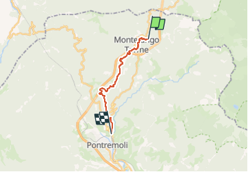
Tocht Te voet van 13,1 km beschikbaar op Toscane, Massa-Carrara, Pontremoli. Deze tocht wordt voorgesteld door SityTrail - itinéraires balisés pédestres.
Beschrijving
Trail created by AVFAL.
Route from Passo del Righetto to SP38 surveyed 26.12.19 by Damiano. Route from SP38 to Mignegno surveyed 20.1.20.
Symbol: yellow and blue stripe
Website: http://francigena-international.org/it_IT/2017/06/29/col-de-la-cisa-pontremoli-variante-de-montelungo-mansiones-de-sigeric/
Plaatsbepaling
Opmerkingen
Wandeltochten in de omgeving
![Tocht Stappen Pontremoli - CR_Francigena_CD_27_Pontremoli-Col-Cisa_Pontremoli_20220609 - Photo](https://media.geolcdn.com/t/375/260/87718559-f947-4574-b407-14a4f0e9da8a.jpg&format=jpg&maxdim=2)
![Stappen Stappen](https://static1.geolcdn.com/sitytour/trail-icons/101.png)
Stappen
![](/images/other/stat-length.png)
![](https://static1.geolcdn.com/siteimages/upload/files/16400158638029165_repeat_loop_refresh_sync_direction_icon.png)
![Tocht Te voet Pontremoli - Trekking Lunigiana 5 - Photo](https://media.geolcdn.com/t/375/260/9dac446e-79d3-4ca6-8d85-283e5c09b810.jpeg&format=jpg&maxdim=2)
![Te voet Te voet](https://static1.geolcdn.com/sitytour/trail-icons/100.png)
Te voet
![](/images/other/stat-length.png)
![](https://static1.geolcdn.com/siteimages/upload/files/16400158638029165_repeat_loop_refresh_sync_direction_icon.png)
![Tocht Te voet Berceto - (SI L24) Passo della Cisa - Passo dei due Santi - Photo](https://media.geolcdn.com/t/375/260/06ded2e4-6f32-4600-8821-eb7a937d7c1f.jpeg&format=jpg&maxdim=2)
![Te voet Te voet](https://static1.geolcdn.com/sitytour/trail-icons/100.png)
Te voet
![](/images/other/stat-length.png)
![](https://static1.geolcdn.com/siteimages/upload/files/16400158638029165_repeat_loop_refresh_sync_direction_icon.png)
![Tocht Te voet Berceto - Il Tugo - Monte Valoria - Photo](https://media.geolcdn.com/t/375/260/54dde4e1-abc9-4262-ae95-27600bf6ec14.jpeg&format=jpg&maxdim=2)
![Te voet Te voet](https://static1.geolcdn.com/sitytour/trail-icons/100.png)
Te voet
![](/images/other/stat-length.png)
![](https://static1.geolcdn.com/siteimages/upload/files/16400158638029165_repeat_loop_refresh_sync_direction_icon.png)
![Tocht Te voet Borgo Val di Taro - Rio delle Arole - Termine del Gatto - Photo](https://media.geolcdn.com/t/375/260/ext.jpg?maxdim=2&url=https%3A%2F%2Fstatic1.geolcdn.com%2Fsiteimages%2Fupload%2Ffiles%2F1545311037marcheuse_200dpi.jpg)
![Te voet Te voet](https://static1.geolcdn.com/sitytour/trail-icons/100.png)
Te voet
![](/images/other/stat-length.png)
![](https://static1.geolcdn.com/siteimages/upload/files/16400158638029165_repeat_loop_refresh_sync_direction_icon.png)
![Tocht Te voet Borgo Val di Taro - Anello del Molinatico - Photo](https://media.geolcdn.com/t/375/260/ext.jpg?maxdim=2&url=https%3A%2F%2Fstatic1.geolcdn.com%2Fsiteimages%2Fupload%2Ffiles%2F1545311037marcheuse_200dpi.jpg)
![Te voet Te voet](https://static1.geolcdn.com/sitytour/trail-icons/100.png)
Te voet
![](/images/other/stat-length.png)
![](https://static1.geolcdn.com/siteimages/upload/files/16400158638029165_repeat_loop_refresh_sync_direction_icon.png)