![](/images/other/stat-length.png)
![Tocht Te voet Le Ribay - FR-109 - Photo](https://media.geolcdn.com/t/1900/400/0746fc10-822e-4d2e-8319-3e8efbb9fe20.jpeg&format=pjpeg&maxdim=2)
FR-109
SityTrail - itinéraires balisés pédestres
Tous les sentiers balisés d’Europe GUIDE+
![Lengte](/images/other/stat-length.png)
Lengte
13,6 km
![Max. hoogte](https://static1.geolcdn.com/siteimages/upload/files/1508320355ic_sort_altitude_max_24dp.png)
Max. hoogte
319 m
![Positief hoogteverschil](https://static1.geolcdn.com/siteimages/upload/files/1508320355ic_sort_den_pos_24dp.png)
Positief hoogteverschil
289 m
![Km-Effort](/images/other/stat-length.png)
Km-Effort
17,4 km
![Min. hoogte](https://static1.geolcdn.com/siteimages/upload/files/1508320355ic_sort_altitude_min_24dp.png)
Min. hoogte
218 m
![Negatief hoogteverschil](https://static1.geolcdn.com/siteimages/upload/files/1508320355ic_sort_den_neg_24dp.png)
Negatief hoogteverschil
288 m
![Boucle](https://static1.geolcdn.com/siteimages/upload/files/16400158638029165_repeat_loop_refresh_sync_direction_icon.png)
Boucle
Ja
Markering
Datum van aanmaak :
2022-02-15 18:02:32.008
Laatste wijziging :
2022-03-02 20:22:40.86
![Te voet](https://static1.geolcdn.com/sitytour/trail-icons/100.png)
3h57
Moeilijkheid : Gemakkelijk
![Scan deze QR-code om de tocht te openen in de SityTrail-applicatie](https://capi.geolives.com/qq0zvz2zws4bq2lad0pu/sitytour/trails/3123244/qr.png?size=200)
Gratisgps-wandelapplicatie
Over ons
Tocht Te voet van 13,6 km beschikbaar op Pays de la Loire, Mayenne, Le Ribay. Deze tocht wordt voorgesteld door SityTrail - itinéraires balisés pédestres.
Beschrijving
Website: http://randomontdesavaloirs.free.fr/
Plaatsbepaling
Land:
France
Regio :
Pays de la Loire
Departement/Provincie :
Mayenne
Gemeente :
Le Ribay
Locatie:
Unknown
Vertrek:(Dec)
Vertrek:(UTM)
692296 ; 5359527 (30U) N.
Opmerkingen
Wandeltochten in de omgeving
![Tocht Te voet Hardanges - Sentier des Buttes d'Hardanges - Photo](https://media.geolcdn.com/t/375/260/e103846b-6a6b-4884-bd81-7e1192a3b663.jpeg&format=jpg&maxdim=2)
![Te voet Te voet](https://static1.geolcdn.com/sitytour/trail-icons/100.png)
Sentier des Buttes d'Hardanges
Te voet
Gemakkelijk
Hardanges,
Pays de la Loire,
Mayenne,
France
![](/images/other/stat-length.png)
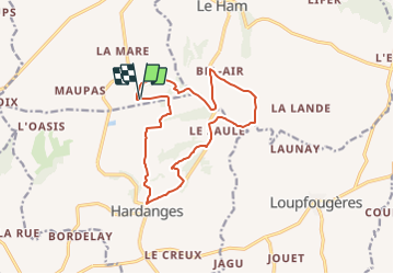
12,3 km | 15,5 km-effort
3h 31min
![](https://static1.geolcdn.com/siteimages/upload/files/16400158638029165_repeat_loop_refresh_sync_direction_icon.png)
Ja
![Tocht Stappen La Chapelle-au-Riboul - la Chapelle au Riboul - Photo](https://media.geolcdn.com/t/375/260/9898fadb-49f2-4cd2-a84c-3891123ac77f.jpg&format=jpg&maxdim=2)
![Stappen Stappen](https://static1.geolcdn.com/sitytour/trail-icons/101.png)
la Chapelle au Riboul
Stappen
Medium
La Chapelle-au-Riboul,
Pays de la Loire,
Mayenne,
France
![](/images/other/stat-length.png)
13,5 km | 15,6 km-effort
2h 50min
![](https://static1.geolcdn.com/siteimages/upload/files/16400158638029165_repeat_loop_refresh_sync_direction_icon.png)
Ja
![Tocht Te voet Le Ribay - Grande Boucle de Ker Avray - Photo](https://media.geolcdn.com/t/375/260/0746fc10-822e-4d2e-8319-3e8efbb9fe20.jpeg&format=jpg&maxdim=2)
![Te voet Te voet](https://static1.geolcdn.com/sitytour/trail-icons/100.png)
Grande Boucle de Ker Avray
Te voet
Gemakkelijk
Le Ribay,
Pays de la Loire,
Mayenne,
France
![](/images/other/stat-length.png)
4,2 km | 5,2 km-effort
1h 11min
![](https://static1.geolcdn.com/siteimages/upload/files/16400158638029165_repeat_loop_refresh_sync_direction_icon.png)
Ja
![Tocht Te voet Le Ribay - Boucle de Belle Etoile - Photo](https://media.geolcdn.com/t/375/260/0746fc10-822e-4d2e-8319-3e8efbb9fe20.jpeg&format=jpg&maxdim=2)
![Te voet Te voet](https://static1.geolcdn.com/sitytour/trail-icons/100.png)
Boucle de Belle Etoile
Te voet
Gemakkelijk
Le Ribay,
Pays de la Loire,
Mayenne,
France
![](/images/other/stat-length.png)
5,4 km | 6,7 km-effort
1h 31min
![](https://static1.geolcdn.com/siteimages/upload/files/16400158638029165_repeat_loop_refresh_sync_direction_icon.png)
Ja
![Tocht Te voet La Chapelle-au-Riboul - Sentier du Gué Marie - Photo](https://media.geolcdn.com/t/375/260/61b69e86-f199-461c-9268-7670a61cb31b.jpeg&format=jpg&maxdim=2)
![Te voet Te voet](https://static1.geolcdn.com/sitytour/trail-icons/100.png)
Sentier du Gué Marie
Te voet
Gemakkelijk
La Chapelle-au-Riboul,
Pays de la Loire,
Mayenne,
France
![](/images/other/stat-length.png)
8,1 km | 9,3 km-effort
2h 6min
![](https://static1.geolcdn.com/siteimages/upload/files/16400158638029165_repeat_loop_refresh_sync_direction_icon.png)
Ja
![Tocht Te voet Le Ribay - Boucle de la vallée de l'Aisne - Photo](https://media.geolcdn.com/t/375/260/ext.jpg?maxdim=2&url=https%3A%2F%2Fstatic1.geolcdn.com%2Fsiteimages%2Fupload%2Ffiles%2F1545311037marcheuse_200dpi.jpg)
![Te voet Te voet](https://static1.geolcdn.com/sitytour/trail-icons/100.png)
Boucle de la vallée de l'Aisne
Te voet
Gemakkelijk
Le Ribay,
Pays de la Loire,
Mayenne,
France
![](/images/other/stat-length.png)
5,3 km | 6,2 km-effort
1h 23min
![](https://static1.geolcdn.com/siteimages/upload/files/16400158638029165_repeat_loop_refresh_sync_direction_icon.png)
Ja
![Tocht Te voet Le Ribay - Circuit de la Laire - Photo](https://media.geolcdn.com/t/375/260/ext.jpg?maxdim=2&url=https%3A%2F%2Fstatic1.geolcdn.com%2Fsiteimages%2Fupload%2Ffiles%2F1545311037marcheuse_200dpi.jpg)
![Te voet Te voet](https://static1.geolcdn.com/sitytour/trail-icons/100.png)
Circuit de la Laire
Te voet
Gemakkelijk
Le Ribay,
Pays de la Loire,
Mayenne,
France
![](/images/other/stat-length.png)
5,8 km | 6,9 km-effort
1h 34min
![](https://static1.geolcdn.com/siteimages/upload/files/16400158638029165_repeat_loop_refresh_sync_direction_icon.png)
Ja
![Tocht Te voet Le Ham - Sentier de Bazeilles - Photo](https://media.geolcdn.com/t/375/260/ext.jpg?maxdim=2&url=https%3A%2F%2Fstatic1.geolcdn.com%2Fsiteimages%2Fupload%2Ffiles%2F1545311037marcheuse_200dpi.jpg)
![Te voet Te voet](https://static1.geolcdn.com/sitytour/trail-icons/100.png)
Sentier de Bazeilles
Te voet
Gemakkelijk
Le Ham,
Pays de la Loire,
Mayenne,
France
![](/images/other/stat-length.png)
10,2 km | 12,8 km-effort
2h 54min
![](https://static1.geolcdn.com/siteimages/upload/files/16400158638029165_repeat_loop_refresh_sync_direction_icon.png)
Ja
![Tocht Te voet Loupfougères - Sentier du loup dans les fougères - Photo](https://media.geolcdn.com/t/375/260/ext.jpg?maxdim=2&url=https%3A%2F%2Fstatic1.geolcdn.com%2Fsiteimages%2Fupload%2Ffiles%2F1545311037marcheuse_200dpi.jpg)
![Te voet Te voet](https://static1.geolcdn.com/sitytour/trail-icons/100.png)
Sentier du loup dans les fougères
Te voet
Gemakkelijk
Loupfougères,
Pays de la Loire,
Mayenne,
France
![](/images/other/stat-length.png)
12,5 km | 14,1 km-effort
3h 12min
![](https://static1.geolcdn.com/siteimages/upload/files/16400158638029165_repeat_loop_refresh_sync_direction_icon.png)
Ja