![](/images/other/stat-length.png)
![Tocht Te voet Canossa - Cavandola - Votigno - Bergogno - Cavandola - Photo](https://media.geolcdn.com/t/1900/400/4101eeb1-c33b-46af-af9a-31946a40632c.jpeg&format=pjpeg&maxdim=2)
Cavandola - Votigno - Bergogno - Cavandola
SityTrail - itinéraires balisés pédestres
Tous les sentiers balisés d’Europe GUIDE+
![Lengte](/images/other/stat-length.png)
Lengte
7,7 km
![Max. hoogte](https://static1.geolcdn.com/siteimages/upload/files/1508320355ic_sort_altitude_max_24dp.png)
Max. hoogte
617 m
![Positief hoogteverschil](https://static1.geolcdn.com/siteimages/upload/files/1508320355ic_sort_den_pos_24dp.png)
Positief hoogteverschil
340 m
![Km-Effort](/images/other/stat-length.png)
Km-Effort
12,2 km
![Min. hoogte](https://static1.geolcdn.com/siteimages/upload/files/1508320355ic_sort_altitude_min_24dp.png)
Min. hoogte
335 m
![Negatief hoogteverschil](https://static1.geolcdn.com/siteimages/upload/files/1508320355ic_sort_den_neg_24dp.png)
Negatief hoogteverschil
345 m
![Boucle](https://static1.geolcdn.com/siteimages/upload/files/16400158638029165_repeat_loop_refresh_sync_direction_icon.png)
Boucle
Ja
Markering
Datum van aanmaak :
2022-02-15 17:48:04.439
Laatste wijziging :
2022-03-01 21:43:04.131
![Te voet](https://static1.geolcdn.com/sitytour/trail-icons/100.png)
2h46
Moeilijkheid : Gemakkelijk
![Scan deze QR-code om de tocht te openen in de SityTrail-applicatie](https://capi.geolives.com/qq0zvz2zws4bq2lad0pu/sitytour/trails/3122905/qr.png?size=200)
Gratisgps-wandelapplicatie
Over ons
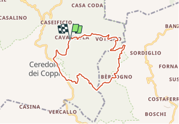
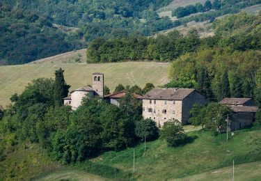
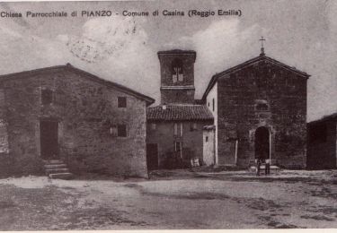
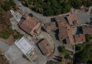
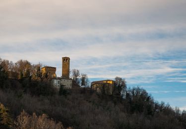
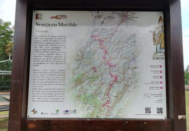
Tocht Te voet van 7,7 km beschikbaar op Emilia-Romagna, Reggio nell'Emilia, Canossa. Deze tocht wordt voorgesteld door SityTrail - itinéraires balisés pédestres.
Beschrijving
Trail created by Provincia di Reggio Emilia.
Symbol: 652 on white red flags
Plaatsbepaling
Land:
Italy
Regio :
Emilia-Romagna
Departement/Provincie :
Reggio nell'Emilia
Gemeente :
Canossa
Locatie:
Unknown
Vertrek:(Dec)
Vertrek:(UTM)
615844 ; 4935631 (32T) N.
Opmerkingen
Wandeltochten in de omgeving
![Tocht Te voet Casina - MIgliara - Montata - Ariolo - Pianzo - Photo](https://media.geolcdn.com/t/375/260/a7f38c0c-d054-4085-ab58-b618ef088ce1.jpeg&format=jpg&maxdim=2)
![Te voet Te voet](https://static1.geolcdn.com/sitytour/trail-icons/100.png)
MIgliara - Montata - Ariolo - Pianzo
Te voet
Gemakkelijk
Casina,
Emilia-Romagna,
Reggio nell'Emilia,
Italy
![](/images/other/stat-length.png)
10,1 km | 15,6 km-effort
3h 33min
![](https://static1.geolcdn.com/siteimages/upload/files/16400158638029165_repeat_loop_refresh_sync_direction_icon.png)
Neen
![Tocht Te voet Casina - Sella di Monte Barazzone - Barazzone - Mulino di Cortogno - Ariolo - Roncolo - Pineto - Photo](https://media.geolcdn.com/t/375/260/3632078f-594f-455e-b15a-42a093ac9282.jpeg&format=jpg&maxdim=2)
![Te voet Te voet](https://static1.geolcdn.com/sitytour/trail-icons/100.png)
Sella di Monte Barazzone - Barazzone - Mulino di Cortogno - Ariolo - Roncolo ...
Te voet
Medium
Casina,
Emilia-Romagna,
Reggio nell'Emilia,
Italy
![](/images/other/stat-length.png)
17,2 km | 24 km-effort
5h 27min
![](https://static1.geolcdn.com/siteimages/upload/files/16400158638029165_repeat_loop_refresh_sync_direction_icon.png)
Neen
![Tocht Te voet Casina - Bergogno - Mulino del Votigno - Casola Canossa - Photo](https://media.geolcdn.com/t/375/260/5bfff336-809d-45ad-8ed0-770684175f1a.jpeg&format=jpg&maxdim=2)
![Te voet Te voet](https://static1.geolcdn.com/sitytour/trail-icons/100.png)
Bergogno - Mulino del Votigno - Casola Canossa
Te voet
Gemakkelijk
Casina,
Emilia-Romagna,
Reggio nell'Emilia,
Italy
![](/images/other/stat-length.png)
4 km | 5,2 km-effort
1h 10min
![](https://static1.geolcdn.com/siteimages/upload/files/16400158638029165_repeat_loop_refresh_sync_direction_icon.png)
Neen
![Tocht Te voet Casina - Bocco - Lezzolo - Paullo - Crocicchio - Cortogno - Mulino di Cortogno - Mulino di Leguigno - Montata - Valletta di Monte Venera - Ariolo - Monte Bocco - Montale - Photo](https://media.geolcdn.com/t/375/260/a7f35108-f7fb-4feb-8072-b434688c4606.jpeg&format=jpg&maxdim=2)
![Te voet Te voet](https://static1.geolcdn.com/sitytour/trail-icons/100.png)
Bocco - Lezzolo - Paullo - Crocicchio - Cortogno - Mulino di Cortogno - Mulin...
Te voet
Medium
Casina,
Emilia-Romagna,
Reggio nell'Emilia,
Italy
![](/images/other/stat-length.png)
14,9 km | 25 km-effort
5h 35min
![](https://static1.geolcdn.com/siteimages/upload/files/16400158638029165_repeat_loop_refresh_sync_direction_icon.png)
Neen
![Tocht Te voet Casina - Mulino del Votigno - Casa Borseto - C.Coda -](https://media.geolcdn.com/t/375/260/88d2114a-c7e5-40c7-9873-ef69d1714390.jpeg&format=jpg&maxdim=2)
![Te voet Te voet](https://static1.geolcdn.com/sitytour/trail-icons/100.png)
Mulino del Votigno - Casa Borseto - C.Coda - "Sentiero Matilde"
Te voet
Gemakkelijk
Casina,
Emilia-Romagna,
Reggio nell'Emilia,
Italy
![](/images/other/stat-length.png)
3,7 km | 5,6 km-effort
1h 16min
![](https://static1.geolcdn.com/siteimages/upload/files/16400158638029165_repeat_loop_refresh_sync_direction_icon.png)
Neen
![Tocht Te voet Canossa - Rossena - Braglie - Ceredolo dei Coppi - Cortogno - Mulino di Cortogno - Casina - Migliara - Photo](https://media.geolcdn.com/t/375/260/91b0fbd7-f625-4829-a6bc-98341f7fa350.jpeg&format=jpg&maxdim=2)
![Te voet Te voet](https://static1.geolcdn.com/sitytour/trail-icons/100.png)
Rossena - Braglie - Ceredolo dei Coppi - Cortogno - Mulino di Cortogno - Casi...
Te voet
Medium
Canossa,
Emilia-Romagna,
Reggio nell'Emilia,
Italy
![](/images/other/stat-length.png)
19,5 km | 28 km-effort
6h 26min
![](https://static1.geolcdn.com/siteimages/upload/files/16400158638029165_repeat_loop_refresh_sync_direction_icon.png)
Neen
![Tocht Te voet Canossa - Puianello - Vezzano - Pecorile - Monte della Sella - Canossa - Photo](https://media.geolcdn.com/t/375/260/eae28f31-e2bb-4c1f-ab78-75dbc1572893.jpeg&format=jpg&maxdim=2)
![Te voet Te voet](https://static1.geolcdn.com/sitytour/trail-icons/100.png)
Puianello - Vezzano - Pecorile - Monte della Sella - Canossa
Te voet
Medium
Canossa,
Emilia-Romagna,
Reggio nell'Emilia,
Italy
![](/images/other/stat-length.png)
18,8 km | 25 km-effort
5h 39min
![](https://static1.geolcdn.com/siteimages/upload/files/16400158638029165_repeat_loop_refresh_sync_direction_icon.png)
Neen
![Tocht Te voet Canossa - Sorbolo - Montecchio Emilia - San Polo D'Enza - Ciano d'Enza - Photo](https://media.geolcdn.com/t/375/260/e0999734-02ca-451a-b0e7-e12d739d028f.jpeg&format=jpg&maxdim=2)
![Te voet Te voet](https://static1.geolcdn.com/sitytour/trail-icons/100.png)
Sorbolo - Montecchio Emilia - San Polo D'Enza - Ciano d'Enza
Te voet
Moeilijk
Canossa,
Emilia-Romagna,
Reggio nell'Emilia,
Italy
![](/images/other/stat-length.png)
32 km | 34 km-effort
7h 44min
![](https://static1.geolcdn.com/siteimages/upload/files/16400158638029165_repeat_loop_refresh_sync_direction_icon.png)
Neen
![Tocht Te voet Vezzano sul Crostolo - Salvarano - Cerro - Bedogno - Bercemme - Montebello - Salvarano - Photo](https://media.geolcdn.com/t/375/260/c7358719-f4d2-43ea-81fd-620668635a33.jpeg&format=jpg&maxdim=2)
![Te voet Te voet](https://static1.geolcdn.com/sitytour/trail-icons/100.png)
Salvarano - Cerro - Bedogno - Bercemme - Montebello - Salvarano
Te voet
Gemakkelijk
Vezzano sul Crostolo,
Emilia-Romagna,
Reggio nell'Emilia,
Italy
![](/images/other/stat-length.png)
8,5 km | 13,4 km-effort
3h 2min
![](https://static1.geolcdn.com/siteimages/upload/files/16400158638029165_repeat_loop_refresh_sync_direction_icon.png)
Neen