![](/images/other/stat-length.png)
![Tocht Te voet Valgoglio - IT-268 - Photo](https://media.geolcdn.com/t/1900/400/e13e67f4-f369-416e-ab43-950817536408.jpeg&format=pjpeg&maxdim=2)
IT-268
SityTrail - itinéraires balisés pédestres
Tous les sentiers balisés d’Europe GUIDE+
![Lengte](/images/other/stat-length.png)
![Max. hoogte](https://static1.geolcdn.com/siteimages/upload/files/1508320355ic_sort_altitude_max_24dp.png)
![Positief hoogteverschil](https://static1.geolcdn.com/siteimages/upload/files/1508320355ic_sort_den_pos_24dp.png)
![Km-Effort](/images/other/stat-length.png)
![Min. hoogte](https://static1.geolcdn.com/siteimages/upload/files/1508320355ic_sort_altitude_min_24dp.png)
![Negatief hoogteverschil](https://static1.geolcdn.com/siteimages/upload/files/1508320355ic_sort_den_neg_24dp.png)
![Boucle](https://static1.geolcdn.com/siteimages/upload/files/16400158638029165_repeat_loop_refresh_sync_direction_icon.png)
![Te voet](https://static1.geolcdn.com/sitytour/trail-icons/100.png)
2h19
Moeilijkheid : Gemakkelijk
![Scan deze QR-code om de tocht te openen in de SityTrail-applicatie](https://capi.geolives.com/qq0zvz2zws4bq2lad0pu/sitytour/trails/3122307/qr.png?size=200)
Gratisgps-wandelapplicatie
Over ons
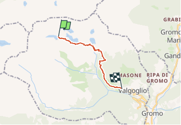
Tocht Te voet van 6,4 km beschikbaar op Lombardije, Bergamo, Valgoglio. Deze tocht wordt voorgesteld door SityTrail - itinéraires balisés pédestres.
Beschrijving
Dopo aver superato il centro di Valgoglio, si prosegue sulla strada che porta alla centrale ENEL (possibilità di parcheggio) fino ad imboccare sulla destra la stradina asfaltata a servizio delle frazioni Valenti e Bortolotti. Il sentiero parte da questo punto (970 m), risalendo per un primo tratto detta strada, poi ritrovando la mulattiera originale che con percorso non
Website: http://geoportale.caibergamo.it/sentiero/268
Plaatsbepaling
Opmerkingen
Wandeltochten in de omgeving
![Tocht Te voet Carona - Sentiero delle Orobie Occidentali - Tappa 6 - Photo](https://media.geolcdn.com/t/375/260/c237ea19-da1c-4881-924c-cb207b0f18eb.jpeg&format=jpg&maxdim=2)
![Te voet Te voet](https://static1.geolcdn.com/sitytour/trail-icons/100.png)
Te voet
![](/images/other/stat-length.png)
![](https://static1.geolcdn.com/siteimages/upload/files/16400158638029165_repeat_loop_refresh_sync_direction_icon.png)
![Tocht Te voet Valgoglio - IT-228 - Photo](https://media.geolcdn.com/t/375/260/e13e67f4-f369-416e-ab43-950817536408.jpeg&format=jpg&maxdim=2)
![Te voet Te voet](https://static1.geolcdn.com/sitytour/trail-icons/100.png)
Te voet
![](/images/other/stat-length.png)
![](https://static1.geolcdn.com/siteimages/upload/files/16400158638029165_repeat_loop_refresh_sync_direction_icon.png)
![Tocht Te voet Valgoglio - Valgoglio - Rifugio Laghi Gemelli - Photo](https://media.geolcdn.com/t/375/260/f3e4daa3-47f9-427a-a665-dfaad3be62d1.jpeg&format=jpg&maxdim=2)
![Te voet Te voet](https://static1.geolcdn.com/sitytour/trail-icons/100.png)
Te voet
![](/images/other/stat-length.png)
![](https://static1.geolcdn.com/siteimages/upload/files/16400158638029165_repeat_loop_refresh_sync_direction_icon.png)
![Tocht Te voet Branzi - Rifugio Laghi Gemelli - Passo d'Aviasco - Photo](https://media.geolcdn.com/t/375/260/2f65df6b-db05-4818-a26d-7af006e6b5dc.jpeg&format=jpg&maxdim=2)
![Te voet Te voet](https://static1.geolcdn.com/sitytour/trail-icons/100.png)
Te voet
![](/images/other/stat-length.png)
![](https://static1.geolcdn.com/siteimages/upload/files/16400158638029165_repeat_loop_refresh_sync_direction_icon.png)
![Tocht Te voet Carona - IT-209 - Photo](https://media.geolcdn.com/t/375/260/2dda619e-2d22-4d18-bff7-ab7fdf50f017.jpeg&format=jpg&maxdim=2)
![Te voet Te voet](https://static1.geolcdn.com/sitytour/trail-icons/100.png)
![Tocht Te voet Branzi - Sentiero delle Orobie Orientali - Tappa 3 - Photo](https://media.geolcdn.com/t/375/260/c237ea19-da1c-4881-924c-cb207b0f18eb.jpeg&format=jpg&maxdim=2)
![Te voet Te voet](https://static1.geolcdn.com/sitytour/trail-icons/100.png)
Te voet
![](/images/other/stat-length.png)
![](https://static1.geolcdn.com/siteimages/upload/files/16400158638029165_repeat_loop_refresh_sync_direction_icon.png)
![Tocht Te voet Carona - (SI D19S) Rifugio Fratelli Calvi - Rifugio Antonio Baroni al Brunone - Photo](https://media.geolcdn.com/t/375/260/2028a224-bfe4-4a78-8f7a-30d3a3abf5ca.jpeg&format=jpg&maxdim=2)
![Te voet Te voet](https://static1.geolcdn.com/sitytour/trail-icons/100.png)
Te voet
![](/images/other/stat-length.png)
![](https://static1.geolcdn.com/siteimages/upload/files/16400158638029165_repeat_loop_refresh_sync_direction_icon.png)
![Tocht Te voet Carona - Sentiero delle Orobie Orientali - Tappa 4 - Photo](https://media.geolcdn.com/t/375/260/2028a224-bfe4-4a78-8f7a-30d3a3abf5ca.jpeg&format=jpg&maxdim=2)
![Te voet Te voet](https://static1.geolcdn.com/sitytour/trail-icons/100.png)
Te voet
![](/images/other/stat-length.png)
![](https://static1.geolcdn.com/siteimages/upload/files/16400158638029165_repeat_loop_refresh_sync_direction_icon.png)
![Tocht Te voet Branzi - Rifugio Laghi Gemelli - Laghi: Colombo, Becco, Marcio - Rifugio Laghi Gemelli - Photo](https://media.geolcdn.com/t/375/260/f3e4daa3-47f9-427a-a665-dfaad3be62d1.jpeg&format=jpg&maxdim=2)
![Te voet Te voet](https://static1.geolcdn.com/sitytour/trail-icons/100.png)
Te voet
![](/images/other/stat-length.png)
![](https://static1.geolcdn.com/siteimages/upload/files/16400158638029165_repeat_loop_refresh_sync_direction_icon.png)