![](/images/other/stat-length.png)
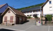
![Tocht Te voet Weiterswiller - Triangle bleu - Photo](https://media.geolcdn.com/t/1900/400/7da8f487-201c-411e-a0e6-a462c915d4f0.jpeg&format=pjpeg&maxdim=2)
Triangle bleu
SityTrail - itinéraires balisés pédestres
Tous les sentiers balisés d’Europe GUIDE+
![Lengte](/images/other/stat-length.png)
Lengte
11,6 km
![Max. hoogte](https://static1.geolcdn.com/siteimages/upload/files/1508320355ic_sort_altitude_max_24dp.png)
Max. hoogte
399 m
![Positief hoogteverschil](https://static1.geolcdn.com/siteimages/upload/files/1508320355ic_sort_den_pos_24dp.png)
Positief hoogteverschil
429 m
![Km-Effort](/images/other/stat-length.png)
Km-Effort
17,3 km
![Min. hoogte](https://static1.geolcdn.com/siteimages/upload/files/1508320355ic_sort_altitude_min_24dp.png)
Min. hoogte
183 m
![Negatief hoogteverschil](https://static1.geolcdn.com/siteimages/upload/files/1508320355ic_sort_den_neg_24dp.png)
Negatief hoogteverschil
435 m
![Boucle](https://static1.geolcdn.com/siteimages/upload/files/16400158638029165_repeat_loop_refresh_sync_direction_icon.png)
Boucle
Neen
Markering
Datum van aanmaak :
2022-02-15 17:00:00.287
Laatste wijziging :
2022-03-02 18:56:35.296
![Te voet](https://static1.geolcdn.com/sitytour/trail-icons/100.png)
3h56
Moeilijkheid : Gemakkelijk
![Scan deze QR-code om de tocht te openen in de SityTrail-applicatie](https://capi.geolives.com/qq0zvz2zws4bq2lad0pu/sitytour/trails/3122051/qr.png?size=200)
Gratisgps-wandelapplicatie
Over ons
Tocht Te voet van 11,6 km beschikbaar op Grand Est, Bas-Rhin, Weiterswiller. Deze tocht wordt voorgesteld door SityTrail - itinéraires balisés pédestres.
Beschrijving
Trail created by Club Vosgien.
Plaatsbepaling
Land:
France
Regio :
Grand Est
Departement/Provincie :
Bas-Rhin
Gemeente :
Weiterswiller
Locatie:
Unknown
Vertrek:(Dec)
Vertrek:(UTM)
383499 ; 5412482 (32U) N.
Opmerkingen
Wandeltochten in de omgeving
![Tocht Paardrijden Dossenheim-sur-Zinsel - 2023-07-09 Picnic CVA Dossenheim sur Zinsel - Photo](https://media.geolcdn.com/t/375/260/2d8e477c-5a5a-4290-8e15-7358176992bc.jpg&format=jpg&maxdim=2)
![Paardrijden Paardrijden](https://static1.geolcdn.com/sitytour/trail-icons/301.png)
2023-07-09 Picnic CVA Dossenheim sur Zinsel
Paardrijden
Medium
Dossenheim-sur-Zinsel,
Grand Est,
Bas-Rhin,
France
![](/images/other/stat-length.png)
29 km | 39 km-effort
5h 45min
![](https://static1.geolcdn.com/siteimages/upload/files/16400158638029165_repeat_loop_refresh_sync_direction_icon.png)
Ja
![Tocht Te voet Neuwiller-lès-Saverne - Croix bleu - Photo](https://media.geolcdn.com/t/375/260/ac14cb89-5ba1-4ba9-9b9a-6e7178a855f4.jpeg&format=jpg&maxdim=2)
![Te voet Te voet](https://static1.geolcdn.com/sitytour/trail-icons/100.png)
Croix bleu
Te voet
Gemakkelijk
Neuwiller-lès-Saverne,
Grand Est,
Bas-Rhin,
France
![](/images/other/stat-length.png)
11,5 km | 17,7 km-effort
4h 0min
![](https://static1.geolcdn.com/siteimages/upload/files/16400158638029165_repeat_loop_refresh_sync_direction_icon.png)
Neen
![Tocht Te voet Neuwiller-lès-Saverne - Disque bleu - Photo](https://media.geolcdn.com/t/375/260/ac14cb89-5ba1-4ba9-9b9a-6e7178a855f4.jpeg&format=jpg&maxdim=2)
![Te voet Te voet](https://static1.geolcdn.com/sitytour/trail-icons/100.png)
Disque bleu
Te voet
Gemakkelijk
Neuwiller-lès-Saverne,
Grand Est,
Bas-Rhin,
France
![](/images/other/stat-length.png)
10,7 km | 15,4 km-effort
3h 30min
![](https://static1.geolcdn.com/siteimages/upload/files/16400158638029165_repeat_loop_refresh_sync_direction_icon.png)
Neen
![Tocht Te voet Weiterswiller - Triangle jaune - Photo](https://media.geolcdn.com/t/375/260/2fc1dde7-68ae-4976-ba71-dd0452ef671a.jpeg&format=jpg&maxdim=2)
![Te voet Te voet](https://static1.geolcdn.com/sitytour/trail-icons/100.png)
Triangle jaune
Te voet
Gemakkelijk
Weiterswiller,
Grand Est,
Bas-Rhin,
France
![](/images/other/stat-length.png)
14,6 km | 19,2 km-effort
4h 22min
![](https://static1.geolcdn.com/siteimages/upload/files/16400158638029165_repeat_loop_refresh_sync_direction_icon.png)
Neen
![Tocht Te voet Sparsbach - Chevalet rouge - Photo](https://media.geolcdn.com/t/375/260/3c8d475f-e614-4147-9cfd-8de0b9d1b061.jpeg&format=jpg&maxdim=2)
![Te voet Te voet](https://static1.geolcdn.com/sitytour/trail-icons/100.png)
Chevalet rouge
Te voet
Gemakkelijk
Sparsbach,
Grand Est,
Bas-Rhin,
France
![](/images/other/stat-length.png)
3,2 km | 5,1 km-effort
1h 9min
![](https://static1.geolcdn.com/siteimages/upload/files/16400158638029165_repeat_loop_refresh_sync_direction_icon.png)
Neen
![Tocht Te voet Dossenheim-sur-Zinsel - Croix rouge - Photo](https://media.geolcdn.com/t/375/260/b7766ade-9612-4826-b6b4-3f8dbf585374.jpeg&format=jpg&maxdim=2)
![Te voet Te voet](https://static1.geolcdn.com/sitytour/trail-icons/100.png)
Croix rouge
Te voet
Gemakkelijk
Dossenheim-sur-Zinsel,
Grand Est,
Bas-Rhin,
France
![](/images/other/stat-length.png)
13,2 km | 17,1 km-effort
3h 53min
![](https://static1.geolcdn.com/siteimages/upload/files/16400158638029165_repeat_loop_refresh_sync_direction_icon.png)
Neen
![Tocht Te voet Erckartswiller - Croix jaune - Photo](https://media.geolcdn.com/t/375/260/b607d783-b0bd-468f-b11d-0c0ef9fca815.jpeg&format=jpg&maxdim=2)
![Te voet Te voet](https://static1.geolcdn.com/sitytour/trail-icons/100.png)
Croix jaune
Te voet
Gemakkelijk
Erckartswiller,
Grand Est,
Bas-Rhin,
France
![](/images/other/stat-length.png)
5,1 km | 6,7 km-effort
1h 31min
![](https://static1.geolcdn.com/siteimages/upload/files/16400158638029165_repeat_loop_refresh_sync_direction_icon.png)
Neen
![Tocht Paardrijden Bouxwiller - rando acpl chez sandra 12 10 24 - Photo](https://media.geolcdn.com/t/375/260/a2844979-4fb4-448e-9fb1-78ecadaf8e17.jpg&format=jpg&maxdim=2)
![Paardrijden Paardrijden](https://static1.geolcdn.com/sitytour/trail-icons/301.png)
rando acpl chez sandra 12 10 24
Paardrijden
Medium
Bouxwiller,
Grand Est,
Bas-Rhin,
France
![](/images/other/stat-length.png)
20 km | 25 km-effort
3h 16min
![](https://static1.geolcdn.com/siteimages/upload/files/16400158638029165_repeat_loop_refresh_sync_direction_icon.png)
Neen
![Tocht Stappen Ingwiller - boucle Ingwiller /Lichtemberg - Photo](https://media.geolcdn.com/t/375/260/1bd23efc-db32-4d4e-bf40-cdd62ec8cb90.jpg&format=jpg&maxdim=2)
![Stappen Stappen](https://static1.geolcdn.com/sitytour/trail-icons/101.png)
boucle Ingwiller /Lichtemberg
Stappen
Medium
Ingwiller,
Grand Est,
Bas-Rhin,
France
![](/images/other/stat-length.png)
20 km | 27 km-effort
5h 9min
![](https://static1.geolcdn.com/siteimages/upload/files/16400158638029165_repeat_loop_refresh_sync_direction_icon.png)
Ja