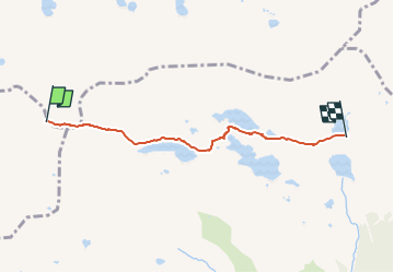
![](/images/other/stat-length.png)
![Tocht Te voet Branzi - Rifugio Baita Cernello - Passo d'Aviasco - Photo](https://media.geolcdn.com/t/1900/400/66abd178-fe8b-4714-ba45-dedef489bb6a.jpeg&format=pjpeg&maxdim=2)
Rifugio Baita Cernello - Passo d'Aviasco
SityTrail - itinéraires balisés pédestres
Tous les sentiers balisés d’Europe GUIDE+
![Lengte](/images/other/stat-length.png)
![Max. hoogte](https://static1.geolcdn.com/siteimages/upload/files/1508320355ic_sort_altitude_max_24dp.png)
![Positief hoogteverschil](https://static1.geolcdn.com/siteimages/upload/files/1508320355ic_sort_den_pos_24dp.png)
![Km-Effort](/images/other/stat-length.png)
![Min. hoogte](https://static1.geolcdn.com/siteimages/upload/files/1508320355ic_sort_altitude_min_24dp.png)
![Negatief hoogteverschil](https://static1.geolcdn.com/siteimages/upload/files/1508320355ic_sort_den_neg_24dp.png)
![Boucle](https://static1.geolcdn.com/siteimages/upload/files/16400158638029165_repeat_loop_refresh_sync_direction_icon.png)
![Te voet](https://static1.geolcdn.com/sitytour/trail-icons/100.png)
1h27
Moeilijkheid : Gemakkelijk
![Scan deze QR-code om de tocht te openen in de SityTrail-applicatie](https://capi.geolives.com/qq0zvz2zws4bq2lad0pu/sitytour/trails/3121687/qr.png?size=200)
Gratisgps-wandelapplicatie
Over ons
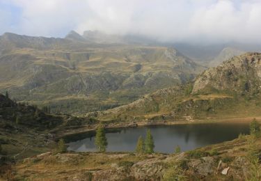
Tocht Te voet van 4,3 km beschikbaar op Lombardije, Bergamo, Branzi. Deze tocht wordt voorgesteld door SityTrail - itinéraires balisés pédestres.
Beschrijving
- ATTENZIONE: il sentiero 229 tra la Baita Cernello ed il Lago di Aviasco non è transitabile per pericolo di frana. In attesa di verifica e di eventuale messa in sicurezza è assolutamente sconsigliato perocorrere detto sentiero. Si invita in alternativa a percorrrere il sentiero 268. (11 settembre 2020).
Website: http://geoportale.caibergamo.it/it/sentiero/229
Plaatsbepaling
Opmerkingen
Wandeltochten in de omgeving
![Tocht Te voet Carona - Sentiero delle Orobie Occidentali - Tappa 6 - Photo](https://media.geolcdn.com/t/375/260/c237ea19-da1c-4881-924c-cb207b0f18eb.jpeg&format=jpg&maxdim=2)
![Te voet Te voet](https://static1.geolcdn.com/sitytour/trail-icons/100.png)
Te voet
![](/images/other/stat-length.png)
![](https://static1.geolcdn.com/siteimages/upload/files/16400158638029165_repeat_loop_refresh_sync_direction_icon.png)
![Tocht Te voet Valgoglio - IT-268 - Photo](https://media.geolcdn.com/t/375/260/e13e67f4-f369-416e-ab43-950817536408.jpeg&format=jpg&maxdim=2)
![Te voet Te voet](https://static1.geolcdn.com/sitytour/trail-icons/100.png)
Te voet
![](/images/other/stat-length.png)
![](https://static1.geolcdn.com/siteimages/upload/files/16400158638029165_repeat_loop_refresh_sync_direction_icon.png)
![Tocht Te voet Valgoglio - Valgoglio - Rifugio Laghi Gemelli - Photo](https://media.geolcdn.com/t/375/260/f3e4daa3-47f9-427a-a665-dfaad3be62d1.jpeg&format=jpg&maxdim=2)
![Te voet Te voet](https://static1.geolcdn.com/sitytour/trail-icons/100.png)
Te voet
![](/images/other/stat-length.png)
![](https://static1.geolcdn.com/siteimages/upload/files/16400158638029165_repeat_loop_refresh_sync_direction_icon.png)
![Tocht Te voet Branzi - Rifugio Laghi Gemelli - Passo d'Aviasco - Photo](https://media.geolcdn.com/t/375/260/2f65df6b-db05-4818-a26d-7af006e6b5dc.jpeg&format=jpg&maxdim=2)
![Te voet Te voet](https://static1.geolcdn.com/sitytour/trail-icons/100.png)
Te voet
![](/images/other/stat-length.png)
![](https://static1.geolcdn.com/siteimages/upload/files/16400158638029165_repeat_loop_refresh_sync_direction_icon.png)
![Tocht Te voet Carona - IT-209 - Photo](https://media.geolcdn.com/t/375/260/2dda619e-2d22-4d18-bff7-ab7fdf50f017.jpeg&format=jpg&maxdim=2)
![Te voet Te voet](https://static1.geolcdn.com/sitytour/trail-icons/100.png)
![Tocht Te voet Carona - IT-207 - Photo](https://media.geolcdn.com/t/375/260/9f63bbdd-75f6-4425-8bfd-5539911a1b67.jpeg&format=jpg&maxdim=2)
![Te voet Te voet](https://static1.geolcdn.com/sitytour/trail-icons/100.png)
![Tocht Te voet Branzi - Sentiero delle Orobie Orientali - Tappa 3 - Photo](https://media.geolcdn.com/t/375/260/c237ea19-da1c-4881-924c-cb207b0f18eb.jpeg&format=jpg&maxdim=2)
![Te voet Te voet](https://static1.geolcdn.com/sitytour/trail-icons/100.png)
Te voet
![](/images/other/stat-length.png)
![](https://static1.geolcdn.com/siteimages/upload/files/16400158638029165_repeat_loop_refresh_sync_direction_icon.png)
![Tocht Te voet Carona - (SI D19S) Rifugio Fratelli Calvi - Rifugio Antonio Baroni al Brunone - Photo](https://media.geolcdn.com/t/375/260/2028a224-bfe4-4a78-8f7a-30d3a3abf5ca.jpeg&format=jpg&maxdim=2)
![Te voet Te voet](https://static1.geolcdn.com/sitytour/trail-icons/100.png)
Te voet
![](/images/other/stat-length.png)
![](https://static1.geolcdn.com/siteimages/upload/files/16400158638029165_repeat_loop_refresh_sync_direction_icon.png)
![Tocht Te voet Carona - Sentiero delle Orobie Orientali - Tappa 4 - Photo](https://media.geolcdn.com/t/375/260/2028a224-bfe4-4a78-8f7a-30d3a3abf5ca.jpeg&format=jpg&maxdim=2)
![Te voet Te voet](https://static1.geolcdn.com/sitytour/trail-icons/100.png)
Te voet
![](/images/other/stat-length.png)
![](https://static1.geolcdn.com/siteimages/upload/files/16400158638029165_repeat_loop_refresh_sync_direction_icon.png)