![](/images/other/stat-length.png)
![Tocht Te voet Allerona - Anello Meana - Photo](https://media.geolcdn.com/t/1900/400/ext.pjpeg?maxdim=2&url=https%3A%2F%2Fstatic1.geolcdn.com%2Fsiteimages%2Fupload%2Ffiles%2F1545311037marcheuse_200dpi.jpg)
Anello Meana
SityTrail - itinéraires balisés pédestres
Tous les sentiers balisés d’Europe GUIDE+
![Lengte](/images/other/stat-length.png)
Lengte
10,6 km
![Max. hoogte](https://static1.geolcdn.com/siteimages/upload/files/1508320355ic_sort_altitude_max_24dp.png)
Max. hoogte
648 m
![Positief hoogteverschil](https://static1.geolcdn.com/siteimages/upload/files/1508320355ic_sort_den_pos_24dp.png)
Positief hoogteverschil
341 m
![Km-Effort](/images/other/stat-length.png)
Km-Effort
15,1 km
![Min. hoogte](https://static1.geolcdn.com/siteimages/upload/files/1508320355ic_sort_altitude_min_24dp.png)
Min. hoogte
322 m
![Negatief hoogteverschil](https://static1.geolcdn.com/siteimages/upload/files/1508320355ic_sort_den_neg_24dp.png)
Negatief hoogteverschil
334 m
![Boucle](https://static1.geolcdn.com/siteimages/upload/files/16400158638029165_repeat_loop_refresh_sync_direction_icon.png)
Boucle
Ja
Markering
Datum van aanmaak :
2022-02-15 15:49:30.021
Laatste wijziging :
2022-03-01 16:35:40.084
![Te voet](https://static1.geolcdn.com/sitytour/trail-icons/100.png)
3h25
Moeilijkheid : Gemakkelijk
![Scan deze QR-code om de tocht te openen in de SityTrail-applicatie](https://capi.geolives.com/qq0zvz2zws4bq2lad0pu/sitytour/trails/3121061/qr.png?size=200)
Gratisgps-wandelapplicatie
Over ons
Tocht Te voet van 10,6 km beschikbaar op Umbrië, Terni, Allerona. Deze tocht wordt voorgesteld door SityTrail - itinéraires balisés pédestres.
Beschrijving
Trail created by Sistema Territoriale di Interesse Naturalistico Ambientale (S.T.I.N.A.).
Plaatsbepaling
Land:
Italy
Regio :
Umbrië
Departement/Provincie :
Terni
Gemeente :
Allerona
Locatie:
Unknown
Vertrek:(Dec)
Vertrek:(UTM)
744671 ; 4740927 (32T) N.
Opmerkingen
Wandeltochten in de omgeving
![Tocht Te voet Allerona - Anello orvietano - Photo](https://media.geolcdn.com/t/375/260/1174a806-5c21-4731-a235-0ee9bbf6bc9e.jpeg&format=jpg&maxdim=2)
![Te voet Te voet](https://static1.geolcdn.com/sitytour/trail-icons/100.png)
Anello orvietano
Te voet
Zeer moeilijk
Allerona,
Umbrië,
Terni,
Italy
![](/images/other/stat-length.png)
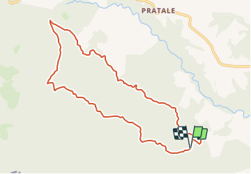
178 km | 249 km-effort
56h 34min
![](https://static1.geolcdn.com/siteimages/upload/files/16400158638029165_repeat_loop_refresh_sync_direction_icon.png)
Ja
![Tocht Te voet Allerona - Anello Villa Cahen - Photo](https://media.geolcdn.com/t/375/260/0b79a6f7-bfa0-4866-952a-519d3559d797.jpeg&format=jpg&maxdim=2)
![Te voet Te voet](https://static1.geolcdn.com/sitytour/trail-icons/100.png)
Anello Villa Cahen
Te voet
Gemakkelijk
Allerona,
Umbrië,
Terni,
Italy
![](/images/other/stat-length.png)
9,7 km | 13,8 km-effort
3h 7min
![](https://static1.geolcdn.com/siteimages/upload/files/16400158638029165_repeat_loop_refresh_sync_direction_icon.png)
Ja