![](/images/other/stat-length.png)
![Tocht Te voet Colere - IT-403 - Photo](https://media.geolcdn.com/t/1900/400/17228836-e5a8-4aa1-96f8-901fa723ac79.jpeg&format=pjpeg&maxdim=2)
IT-403
SityTrail - itinéraires balisés pédestres
Tous les sentiers balisés d’Europe GUIDE+
![Lengte](/images/other/stat-length.png)
![Max. hoogte](https://static1.geolcdn.com/siteimages/upload/files/1508320355ic_sort_altitude_max_24dp.png)
![Positief hoogteverschil](https://static1.geolcdn.com/siteimages/upload/files/1508320355ic_sort_den_pos_24dp.png)
![Km-Effort](/images/other/stat-length.png)
![Min. hoogte](https://static1.geolcdn.com/siteimages/upload/files/1508320355ic_sort_altitude_min_24dp.png)
![Negatief hoogteverschil](https://static1.geolcdn.com/siteimages/upload/files/1508320355ic_sort_den_neg_24dp.png)
![Boucle](https://static1.geolcdn.com/siteimages/upload/files/16400158638029165_repeat_loop_refresh_sync_direction_icon.png)
![Te voet](https://static1.geolcdn.com/sitytour/trail-icons/100.png)
2h47
Moeilijkheid : Gemakkelijk
![Scan deze QR-code om de tocht te openen in de SityTrail-applicatie](https://capi.geolives.com/qq0zvz2zws4bq2lad0pu/sitytour/trails/3120560/qr.png?size=200)
Gratisgps-wandelapplicatie
Over ons
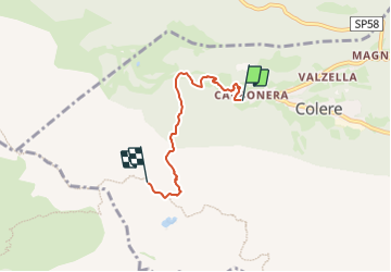
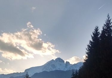
Tocht Te voet van 3,9 km beschikbaar op Lombardije, Bergamo, Colere. Deze tocht wordt voorgesteld door SityTrail - itinéraires balisés pédestres.
Beschrijving
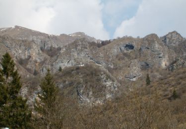
Dalla frazione Carbonera di Colere (1043 m - parcheggio impianti di sci) si sale lungo la strada forestale che porta alla Malga Polzone (vedi anche sentiero 404) per circa 1 km fino a quota 1239 m. Si prende il sentiero sulla sinistra e si prosegue il cammino, attraversando il bosco fino a quota 1680 m dove si incrocia il sentiero 406.
Website: http://geoportale.caibergamo.it/it/sentiero/403
Plaatsbepaling
Opmerkingen
Wandeltochten in de omgeving
![Tocht Te voet Vilminore di Scalve - IT-407 - Photo](https://media.geolcdn.com/t/375/260/3a344b4e-a35f-4190-ad72-4463857492f4.jpeg&format=jpg&maxdim=2)
![Te voet Te voet](https://static1.geolcdn.com/sitytour/trail-icons/100.png)
Te voet
![](/images/other/stat-length.png)
![](https://static1.geolcdn.com/siteimages/upload/files/16400158638029165_repeat_loop_refresh_sync_direction_icon.png)
![Tocht Te voet Colere - IT-401 - Photo](https://media.geolcdn.com/t/375/260/6123d9d7-cca3-4b52-b64f-f80d90363769.jpeg&format=jpg&maxdim=2)
![Te voet Te voet](https://static1.geolcdn.com/sitytour/trail-icons/100.png)
![Tocht Te voet Oltressenda Alta - CAI320: Baite del Möschel - Grotta dei Pagani - Photo](https://media.geolcdn.com/t/375/260/07ed0ca4-c94e-41ba-9d8b-58c3c04ec842.jpeg&format=jpg&maxdim=2)
![Te voet Te voet](https://static1.geolcdn.com/sitytour/trail-icons/100.png)
Te voet
![](/images/other/stat-length.png)
![](https://static1.geolcdn.com/siteimages/upload/files/16400158638029165_repeat_loop_refresh_sync_direction_icon.png)
![Tocht Te voet Colere - Sentiero delle Orobie Orientali - Tappa finale Anello - Photo](https://media.geolcdn.com/t/375/260/08606b6c-30fc-4584-b124-177dd3367da7.jpeg&format=jpg&maxdim=2)
![Te voet Te voet](https://static1.geolcdn.com/sitytour/trail-icons/100.png)
Te voet
![](/images/other/stat-length.png)
![](https://static1.geolcdn.com/siteimages/upload/files/16400158638029165_repeat_loop_refresh_sync_direction_icon.png)
![Tocht Te voet Colere - Sentiero delle Orobie Orientali - Tappa finale Classico - Photo](https://media.geolcdn.com/t/375/260/76765d9a-4898-4654-8692-0eca7d7ca2c7.jpeg&format=jpg&maxdim=2)
![Te voet Te voet](https://static1.geolcdn.com/sitytour/trail-icons/100.png)
Te voet
![](/images/other/stat-length.png)
![](https://static1.geolcdn.com/siteimages/upload/files/16400158638029165_repeat_loop_refresh_sync_direction_icon.png)
![Tocht Te voet Colere - IT-404 - Photo](https://media.geolcdn.com/t/375/260/17228836-e5a8-4aa1-96f8-901fa723ac79.jpeg&format=jpg&maxdim=2)
![Te voet Te voet](https://static1.geolcdn.com/sitytour/trail-icons/100.png)
![Tocht Te voet Azzone - Trekking tra malghe e menhir anello 3: Salven - Costone - San Fermo - Photo](https://media.geolcdn.com/t/375/260/bd6171fc-f596-402b-93aa-c7a5279637c8.jpeg&format=jpg&maxdim=2)
![Te voet Te voet](https://static1.geolcdn.com/sitytour/trail-icons/100.png)
Te voet
![](/images/other/stat-length.png)
![](https://static1.geolcdn.com/siteimages/upload/files/16400158638029165_repeat_loop_refresh_sync_direction_icon.png)
![Tocht Te voet Colere - CAI326: Rifugio Albani - Monte Visolo (ferrata della Porta) - Photo](https://media.geolcdn.com/t/375/260/76765d9a-4898-4654-8692-0eca7d7ca2c7.jpeg&format=jpg&maxdim=2)
![Te voet Te voet](https://static1.geolcdn.com/sitytour/trail-icons/100.png)
Te voet
![](/images/other/stat-length.png)
![](https://static1.geolcdn.com/siteimages/upload/files/16400158638029165_repeat_loop_refresh_sync_direction_icon.png)
![Tocht Te voet Castione della Presolana - Castione - Via del Latte - Photo](https://media.geolcdn.com/t/375/260/05fc9400-47e5-4353-874a-589cb2e1281f.jpeg&format=jpg&maxdim=2)
![Te voet Te voet](https://static1.geolcdn.com/sitytour/trail-icons/100.png)
Te voet
![](/images/other/stat-length.png)
![](https://static1.geolcdn.com/siteimages/upload/files/16400158638029165_repeat_loop_refresh_sync_direction_icon.png)