![](/images/other/stat-length.png)
![Tocht Te voet Monteviale - Sentiero del Perozzo - Photo](https://media.geolcdn.com/t/1900/400/d0a68181-bcc7-4f18-95bf-99f5f8d1d25e.jpeg&format=pjpeg&maxdim=2)
Sentiero del Perozzo
SityTrail - itinéraires balisés pédestres
Tous les sentiers balisés d’Europe GUIDE+
![Lengte](/images/other/stat-length.png)
Lengte
6,2 km
![Max. hoogte](https://static1.geolcdn.com/siteimages/upload/files/1508320355ic_sort_altitude_max_24dp.png)
Max. hoogte
181 m
![Positief hoogteverschil](https://static1.geolcdn.com/siteimages/upload/files/1508320355ic_sort_den_pos_24dp.png)
Positief hoogteverschil
169 m
![Km-Effort](/images/other/stat-length.png)
Km-Effort
8,4 km
![Min. hoogte](https://static1.geolcdn.com/siteimages/upload/files/1508320355ic_sort_altitude_min_24dp.png)
Min. hoogte
36 m
![Negatief hoogteverschil](https://static1.geolcdn.com/siteimages/upload/files/1508320355ic_sort_den_neg_24dp.png)
Negatief hoogteverschil
166 m
![Boucle](https://static1.geolcdn.com/siteimages/upload/files/16400158638029165_repeat_loop_refresh_sync_direction_icon.png)
Boucle
Ja
Markering
Datum van aanmaak :
2022-02-15 14:54:54.675
Laatste wijziging :
2022-03-01 15:22:25.349
![Te voet](https://static1.geolcdn.com/sitytour/trail-icons/100.png)
1h55
Moeilijkheid : Gemakkelijk
![Scan deze QR-code om de tocht te openen in de SityTrail-applicatie](https://capi.geolives.com/qq0zvz2zws4bq2lad0pu/sitytour/trails/3120456/qr.png?size=200)
Gratisgps-wandelapplicatie
Over ons
Tocht Te voet van 6,2 km beschikbaar op Veneto, Vicenza, Monteviale. Deze tocht wordt voorgesteld door SityTrail - itinéraires balisés pédestres.
Beschrijving
Trail created by Comune di Monteviale.
Preferibile farlo in senso orario in mountain-bike
Plaatsbepaling
Land:
Italy
Regio :
Veneto
Departement/Provincie :
Vicenza
Gemeente :
Monteviale
Locatie:
Unknown
Vertrek:(Dec)
Vertrek:(UTM)
693235 ; 5049033 (32T) N.
Opmerkingen
Wandeltochten in de omgeving
![Tocht Te voet Monteviale - Sentiero Zuccheriei - delle Are - Photo](https://media.geolcdn.com/t/375/260/5f6ccbb5-3dc5-4d61-9e9b-c1304fd218c1.jpeg&format=jpg&maxdim=2)
![Te voet Te voet](https://static1.geolcdn.com/sitytour/trail-icons/100.png)
Sentiero Zuccheriei - delle Are
Te voet
Gemakkelijk
Monteviale,
Veneto,
Vicenza,
Italy
![](/images/other/stat-length.png)
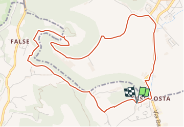
3,3 km | 3,7 km-effort
50min
![](https://static1.geolcdn.com/siteimages/upload/files/16400158638029165_repeat_loop_refresh_sync_direction_icon.png)
Ja
![Tocht Te voet Monteviale - Sentiero Strada False - Photo](https://media.geolcdn.com/t/375/260/5f6ccbb5-3dc5-4d61-9e9b-c1304fd218c1.jpeg&format=jpg&maxdim=2)
![Te voet Te voet](https://static1.geolcdn.com/sitytour/trail-icons/100.png)
Sentiero Strada False
Te voet
Gemakkelijk
Monteviale,
Veneto,
Vicenza,
Italy
![](/images/other/stat-length.png)
3,8 km | 4,7 km-effort
1h 4min
![](https://static1.geolcdn.com/siteimages/upload/files/16400158638029165_repeat_loop_refresh_sync_direction_icon.png)
Neen
![Tocht Te voet Monteviale - Sentiero Vegrolongo - della Sorgente - dell'Ornaro - Photo](https://media.geolcdn.com/t/375/260/5f6ccbb5-3dc5-4d61-9e9b-c1304fd218c1.jpeg&format=jpg&maxdim=2)
![Te voet Te voet](https://static1.geolcdn.com/sitytour/trail-icons/100.png)
Sentiero Vegrolongo - della Sorgente - dell'Ornaro
Te voet
Gemakkelijk
Monteviale,
Veneto,
Vicenza,
Italy
![](/images/other/stat-length.png)
5,5 km | 7,8 km-effort
1h 46min
![](https://static1.geolcdn.com/siteimages/upload/files/16400158638029165_repeat_loop_refresh_sync_direction_icon.png)
Neen
![Tocht Te voet Monteviale - Sentiero Canestrello - Photo](https://media.geolcdn.com/t/375/260/5f6ccbb5-3dc5-4d61-9e9b-c1304fd218c1.jpeg&format=jpg&maxdim=2)
![Te voet Te voet](https://static1.geolcdn.com/sitytour/trail-icons/100.png)
Sentiero Canestrello
Te voet
Gemakkelijk
Monteviale,
Veneto,
Vicenza,
Italy
![](/images/other/stat-length.png)
4,5 km | 6,2 km-effort
1h 24min
![](https://static1.geolcdn.com/siteimages/upload/files/16400158638029165_repeat_loop_refresh_sync_direction_icon.png)
Ja