![](/images/other/stat-length.png)
![Tocht Te voet Biella - Cammino di San Carlo - Photo](https://media.geolcdn.com/t/1900/400/be45e447-ead7-4556-bd40-40613d461944.jpeg&format=pjpeg&maxdim=2)
Cammino di San Carlo
SityTrail - itinéraires balisés pédestres
Tous les sentiers balisés d’Europe GUIDE+
![Lengte](/images/other/stat-length.png)
Lengte
17,9 km
![Max. hoogte](https://static1.geolcdn.com/siteimages/upload/files/1508320355ic_sort_altitude_max_24dp.png)
Max. hoogte
1261 m
![Positief hoogteverschil](https://static1.geolcdn.com/siteimages/upload/files/1508320355ic_sort_den_pos_24dp.png)
Positief hoogteverschil
694 m
![Km-Effort](/images/other/stat-length.png)
Km-Effort
27 km
![Min. hoogte](https://static1.geolcdn.com/siteimages/upload/files/1508320355ic_sort_altitude_min_24dp.png)
Min. hoogte
773 m
![Negatief hoogteverschil](https://static1.geolcdn.com/siteimages/upload/files/1508320355ic_sort_den_neg_24dp.png)
Negatief hoogteverschil
662 m
![Boucle](https://static1.geolcdn.com/siteimages/upload/files/16400158638029165_repeat_loop_refresh_sync_direction_icon.png)
Boucle
Neen
Markering
Datum van aanmaak :
2022-02-15 14:35:14.192
Laatste wijziging :
2022-03-01 14:52:25.298
![Te voet](https://static1.geolcdn.com/sitytour/trail-icons/100.png)
6h09
Moeilijkheid : Medium
![Scan deze QR-code om de tocht te openen in de SityTrail-applicatie](https://capi.geolives.com/qq0zvz2zws4bq2lad0pu/sitytour/trails/3120073/qr.png?size=200)
Gratisgps-wandelapplicatie
Over ons
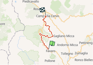
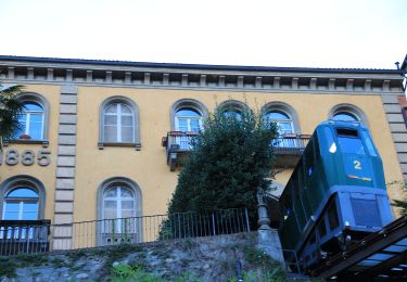
Tocht Te voet van 17,9 km beschikbaar op Piëmont, Biella, Biella. Deze tocht wordt voorgesteld door SityTrail - itinéraires balisés pédestres.
Beschrijving
Trail created by CoEur.
Symbol: yellow crozier in a purple dot
Website: http://www.camminidevozionali.it/it/percorsi-devozionali
Plaatsbepaling
Land:
Italy
Regio :
Piëmont
Departement/Provincie :
Biella
Gemeente :
Biella
Locatie:
Unknown
Vertrek:(Dec)
Vertrek:(UTM)
422252 ; 5050174 (32T) N.
Opmerkingen
Wandeltochten in de omgeving
![Tocht Te voet Biella - (SI E44) Santuario di Oropa - Santuario San Giovanni d'Adorno - Photo](https://media.geolcdn.com/t/375/260/8229be96-d42c-4009-82a8-12dfb01fd565.jpeg&format=jpg&maxdim=2)
![Te voet Te voet](https://static1.geolcdn.com/sitytour/trail-icons/100.png)
(SI E44) Santuario di Oropa - Santuario San Giovanni d'Adorno
Te voet
Gemakkelijk
Biella,
Piëmont,
Biella,
Italy
![](/images/other/stat-length.png)
8 km | 14,1 km-effort
3h 12min
![](https://static1.geolcdn.com/siteimages/upload/files/16400158638029165_repeat_loop_refresh_sync_direction_icon.png)
Neen
![Tocht Te voet Biella - IT-D01 - Photo](https://media.geolcdn.com/t/375/260/08cfdcca-644c-47b5-8fea-057fa1654436.jpeg&format=jpg&maxdim=2)
![Te voet Te voet](https://static1.geolcdn.com/sitytour/trail-icons/100.png)
![Tocht Te voet Biella - D06 - Vecchia tramvia Biella-Oropa - Photo](https://media.geolcdn.com/t/375/260/593dbb64-133b-4e38-9c84-8f37ff29ded3.jpeg&format=jpg&maxdim=2)
![Te voet Te voet](https://static1.geolcdn.com/sitytour/trail-icons/100.png)
D06 - Vecchia tramvia Biella-Oropa
Te voet
Gemakkelijk
Biella,
Piëmont,
Biella,
Italy
![](/images/other/stat-length.png)
3,5 km | 4,4 km-effort
1h 0min
![](https://static1.geolcdn.com/siteimages/upload/files/16400158638029165_repeat_loop_refresh_sync_direction_icon.png)
Neen
![Tocht Te voet Biella - IT-D15 - Photo](https://media.geolcdn.com/t/375/260/2fd6cdc6-c472-4a33-a984-6315858028b3.jpeg&format=jpg&maxdim=2)
![Te voet Te voet](https://static1.geolcdn.com/sitytour/trail-icons/100.png)
![Tocht Te voet Muzzano - IT-S04 - Photo](https://media.geolcdn.com/t/375/260/36d20205-a0c5-4d28-821a-0480ae2a2257.jpeg&format=jpg&maxdim=2)
![Te voet Te voet](https://static1.geolcdn.com/sitytour/trail-icons/100.png)
![Tocht Te voet Sagliano Micca - IT-E87 - Photo](https://media.geolcdn.com/t/375/260/c06e60c4-48d7-46d3-b7e7-20f0eab1a2a4.jpeg&format=jpg&maxdim=2)
![Te voet Te voet](https://static1.geolcdn.com/sitytour/trail-icons/100.png)
IT-E87
Te voet
Gemakkelijk
Sagliano Micca,
Piëmont,
Biella,
Italy
![](/images/other/stat-length.png)
4,3 km | 10,2 km-effort
2h 18min
![](https://static1.geolcdn.com/siteimages/upload/files/16400158638029165_repeat_loop_refresh_sync_direction_icon.png)
Neen
![Tocht Te voet Occhieppo Superiore - IT-D51 - Photo](https://media.geolcdn.com/t/375/260/9b6d3a0f-09c6-4089-b130-69dabe2dd9e1.jpeg&format=jpg&maxdim=2)
![Te voet Te voet](https://static1.geolcdn.com/sitytour/trail-icons/100.png)
IT-D51
Te voet
Gemakkelijk
Occhieppo Superiore,
Piëmont,
Biella,
Italy
![](/images/other/stat-length.png)
9,9 km | 17,3 km-effort
3h 55min
![](https://static1.geolcdn.com/siteimages/upload/files/16400158638029165_repeat_loop_refresh_sync_direction_icon.png)
Neen
![Tocht Te voet Biella - IT-D34 - Photo](https://media.geolcdn.com/t/375/260/593dbb64-133b-4e38-9c84-8f37ff29ded3.jpeg&format=jpg&maxdim=2)
![Te voet Te voet](https://static1.geolcdn.com/sitytour/trail-icons/100.png)
![Tocht Te voet Pollone - IT-C46 - Photo](https://media.geolcdn.com/t/375/260/82af75b5-aa10-4bfc-ab68-0e43b8230ecb.jpeg&format=jpg&maxdim=2)
![Te voet Te voet](https://static1.geolcdn.com/sitytour/trail-icons/100.png)