![](/images/other/stat-length.png)
![Tocht Te voet Piegaro - Montarale - Greppolischieto - Photo](https://media.geolcdn.com/t/1900/400/ext.pjpeg?maxdim=2&url=https%3A%2F%2Fmedia.geolcdn.com%2Ff%2Fae40b1e6-3fe6-4a0a-96ba-6e59c0c8144e.jpeg)
Montarale - Greppolischieto
SityTrail - itinéraires balisés pédestres
Tous les sentiers balisés d’Europe PRO
![Lengte](/images/other/stat-length.png)
Lengte
11,4 km
![Max. hoogte](https://static1.geolcdn.com/siteimages/upload/files/1508320355ic_sort_altitude_max_24dp.png)
Max. hoogte
853 m
![Positief hoogteverschil](https://static1.geolcdn.com/siteimages/upload/files/1508320355ic_sort_den_pos_24dp.png)
Positief hoogteverschil
454 m
![Km-Effort](/images/other/stat-length.png)
Km-Effort
17,5 km
![Min. hoogte](https://static1.geolcdn.com/siteimages/upload/files/1508320355ic_sort_altitude_min_24dp.png)
Min. hoogte
470 m
![Negatief hoogteverschil](https://static1.geolcdn.com/siteimages/upload/files/1508320355ic_sort_den_neg_24dp.png)
Negatief hoogteverschil
457 m
![Boucle](https://static1.geolcdn.com/siteimages/upload/files/16400158638029165_repeat_loop_refresh_sync_direction_icon.png)
Boucle
Ja
Markering
Datum van aanmaak :
2022-02-15 14:31:25.226
Laatste wijziging :
2022-03-01 14:32:11.471
![Te voet](https://static1.geolcdn.com/sitytour/trail-icons/100.png)
3h58
Moeilijkheid : Gemakkelijk
![Scan deze QR-code om de tocht te openen in de SityTrail-applicatie](https://capi.geolives.com/qq0zvz2zws4bq2lad0pu/sitytour/trails/3119984/qr.png?size=200)
Gratisgps-wandelapplicatie
Over ons
Tocht Te voet van 11,4 km beschikbaar op Umbrië, Perugia, Piegaro. Deze tocht wordt voorgesteld door SityTrail - itinéraires balisés pédestres.
Beschrijving
Trail created by CAI Perugia.
number of itinerary being updated Umbria Excursion Network
Symbol: 925 on white red flag
Plaatsbepaling
Land:
Italy
Regio :
Umbrië
Departement/Provincie :
Perugia
Gemeente :
Piegaro
Locatie:
Unknown
Vertrek:(Dec)
Vertrek:(UTM)
264866 ; 4758483 (33T) N.
Opmerkingen
Wandeltochten in de omgeving
![Tocht Te voet Allerona - Anello orvietano - Photo](https://media.geolcdn.com/t/375/260/ext.jpg?maxdim=2&url=https%3A%2F%2Fmedia.geolcdn.com%2Ff%2F1174a806-5c21-4731-a235-0ee9bbf6bc9e.jpeg)
![Te voet Te voet](https://static1.geolcdn.com/sitytour/trail-icons/100.png)
Anello orvietano
Te voet
Zeer moeilijk
Allerona,
Umbrië,
Terni,
Italy
![](/images/other/stat-length.png)
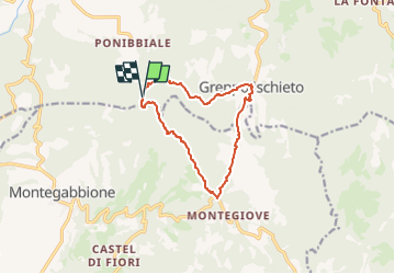
178 km | 249 km-effort
56h 34min
![](https://static1.geolcdn.com/siteimages/upload/files/16400158638029165_repeat_loop_refresh_sync_direction_icon.png)
Ja
![Tocht Te voet Allerona - Anello Villa Cahen - Photo](https://media.geolcdn.com/t/375/260/ext.jpg?maxdim=2&url=https%3A%2F%2Fmedia.geolcdn.com%2Ff%2F0b79a6f7-bfa0-4866-952a-519d3559d797.jpeg)
![Te voet Te voet](https://static1.geolcdn.com/sitytour/trail-icons/100.png)
Anello Villa Cahen
Te voet
Gemakkelijk
Allerona,
Umbrië,
Terni,
Italy
![](/images/other/stat-length.png)
9,7 km | 13,8 km-effort
3h 7min
![](https://static1.geolcdn.com/siteimages/upload/files/16400158638029165_repeat_loop_refresh_sync_direction_icon.png)
Ja
![Tocht Te voet Marsciano - Migliano - Fersinone - Fibbino - Photo](https://media.geolcdn.com/t/375/260/ext.jpg?maxdim=2&url=https%3A%2F%2Fmedia.geolcdn.com%2Ff%2F34e62cdf-ac07-4a05-8b44-95eccc15f38f.jpeg)
![Te voet Te voet](https://static1.geolcdn.com/sitytour/trail-icons/100.png)
Migliano - Fersinone - Fibbino
Te voet
Gemakkelijk
Marsciano,
Umbrië,
Perugia,
Italy
![](/images/other/stat-length.png)
13,4 km | 19,1 km-effort
4h 20min
![](https://static1.geolcdn.com/siteimages/upload/files/16400158638029165_repeat_loop_refresh_sync_direction_icon.png)
Ja
![Tocht Te voet Marsciano - Compignano - Monte Lagello - Mercatello - Photo](https://media.geolcdn.com/t/375/260/ext.jpg?maxdim=2&url=https%3A%2F%2Fmedia.geolcdn.com%2Ff%2Feb9fa763-b59d-4cd9-99c8-ca12c3eb3449.jpeg)
![Te voet Te voet](https://static1.geolcdn.com/sitytour/trail-icons/100.png)
Compignano - Monte Lagello - Mercatello
Te voet
Gemakkelijk
Marsciano,
Umbrië,
Perugia,
Italy
![](/images/other/stat-length.png)
10,8 km | 14,8 km-effort
3h 21min
![](https://static1.geolcdn.com/siteimages/upload/files/16400158638029165_repeat_loop_refresh_sync_direction_icon.png)
Ja
![Tocht Te voet Città della Pieve - Città della Pieve - Fosso Molinella - Photo](https://media.geolcdn.com/t/375/260/ext.jpg?maxdim=2&url=https%3A%2F%2Fmedia.geolcdn.com%2Ff%2F1f8c7f25-61a1-48e7-b201-7bace27086b0.jpeg)
![Te voet Te voet](https://static1.geolcdn.com/sitytour/trail-icons/100.png)
Città della Pieve - Fosso Molinella
Te voet
Gemakkelijk
Città della Pieve,
Umbrië,
Perugia,
Italy
![](/images/other/stat-length.png)
7 km | 10 km-effort
2h 16min
![](https://static1.geolcdn.com/siteimages/upload/files/16400158638029165_repeat_loop_refresh_sync_direction_icon.png)
Ja
![Tocht Te voet Paciano - Paciano - Monte Pausillo - Photo](https://media.geolcdn.com/t/375/260/ext.jpg?maxdim=2&url=https%3A%2F%2Fmedia.geolcdn.com%2Ff%2Fa35c7c88-b11c-4ee4-a692-6c835c624d42.jpeg)
![Te voet Te voet](https://static1.geolcdn.com/sitytour/trail-icons/100.png)
Paciano - Monte Pausillo
Te voet
Gemakkelijk
Paciano,
Umbrië,
Perugia,
Italy
![](/images/other/stat-length.png)
10,3 km | 15,4 km-effort
3h 30min
![](https://static1.geolcdn.com/siteimages/upload/files/16400158638029165_repeat_loop_refresh_sync_direction_icon.png)
Ja
![Tocht Te voet Panicale - Mongiovino - Buca Calcinaro - Photo](https://media.geolcdn.com/t/375/260/ext.jpg?maxdim=2&url=https%3A%2F%2Fmedia.geolcdn.com%2Ff%2Fc7eff8bb-9a32-4819-a6ee-194766842217.jpeg)
![Te voet Te voet](https://static1.geolcdn.com/sitytour/trail-icons/100.png)
Mongiovino - Buca Calcinaro
Te voet
Gemakkelijk
Panicale,
Umbrië,
Perugia,
Italy
![](/images/other/stat-length.png)
10,8 km | 16,3 km-effort
3h 42min
![](https://static1.geolcdn.com/siteimages/upload/files/16400158638029165_repeat_loop_refresh_sync_direction_icon.png)
Ja
![Tocht Te voet Perugia - Fontignano - Montali - M. Solare - Photo](https://media.geolcdn.com/t/375/260/ext.jpg?maxdim=2&url=https%3A%2F%2Fmedia.geolcdn.com%2Ff%2Fe2b8d618-7e3b-4bad-80be-2b8faa81118e.jpeg)
![Te voet Te voet](https://static1.geolcdn.com/sitytour/trail-icons/100.png)
Fontignano - Montali - M. Solare
Te voet
Medium
Perugia,
Umbrië,
Perugia,
Italy
![](/images/other/stat-length.png)
14,3 km | 20 km-effort
4h 36min
![](https://static1.geolcdn.com/siteimages/upload/files/16400158638029165_repeat_loop_refresh_sync_direction_icon.png)
Ja
![Tocht Te voet Magione - Montemelino - Monte Penna - Monte Sperello - Monte Castiglionaccio - Photo](https://media.geolcdn.com/t/375/260/ext.jpg?maxdim=2&url=https%3A%2F%2Fmedia.geolcdn.com%2Ff%2F4a090a14-f11a-4727-b2b9-01d604ab9c29.jpeg)
![Te voet Te voet](https://static1.geolcdn.com/sitytour/trail-icons/100.png)
Montemelino - Monte Penna - Monte Sperello - Monte Castiglionaccio
Te voet
Gemakkelijk
Magione,
Umbrië,
Perugia,
Italy
![](/images/other/stat-length.png)
13,3 km | 19,5 km-effort
4h 25min
![](https://static1.geolcdn.com/siteimages/upload/files/16400158638029165_repeat_loop_refresh_sync_direction_icon.png)
Ja