![](/images/other/stat-length.png)
![Tocht Te voet Canzo - IT-3 - Photo](https://media.geolcdn.com/t/1900/400/4aa45b08-9bf7-4603-a963-73fbcfa8bd59.jpeg&format=pjpeg&maxdim=2)
IT-3
SityTrail - itinéraires balisés pédestres
Tous les sentiers balisés d’Europe GUIDE+
![Lengte](/images/other/stat-length.png)
Lengte
7,2 km
![Max. hoogte](https://static1.geolcdn.com/siteimages/upload/files/1508320355ic_sort_altitude_max_24dp.png)
Max. hoogte
1231 m
![Positief hoogteverschil](https://static1.geolcdn.com/siteimages/upload/files/1508320355ic_sort_den_pos_24dp.png)
Positief hoogteverschil
948 m
![Km-Effort](/images/other/stat-length.png)
Km-Effort
18 km
![Min. hoogte](https://static1.geolcdn.com/siteimages/upload/files/1508320355ic_sort_altitude_min_24dp.png)
Min. hoogte
458 m
![Negatief hoogteverschil](https://static1.geolcdn.com/siteimages/upload/files/1508320355ic_sort_den_neg_24dp.png)
Negatief hoogteverschil
404 m
![Boucle](https://static1.geolcdn.com/siteimages/upload/files/16400158638029165_repeat_loop_refresh_sync_direction_icon.png)
Boucle
Neen
Markering
Datum van aanmaak :
2022-02-15 13:58:47.821
Laatste wijziging :
2022-03-01 13:41:33.895
![Te voet](https://static1.geolcdn.com/sitytour/trail-icons/100.png)
4h05
Moeilijkheid : Gemakkelijk
![Scan deze QR-code om de tocht te openen in de SityTrail-applicatie](https://capi.geolives.com/qq0zvz2zws4bq2lad0pu/sitytour/trails/3119673/qr.png?size=200)
Gratisgps-wandelapplicatie
Over ons
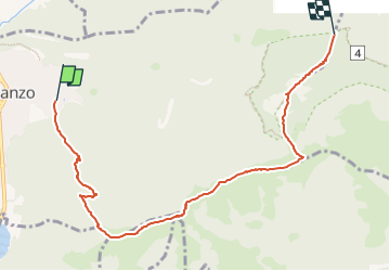
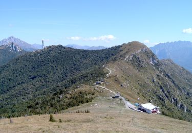
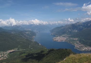
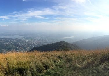
Tocht Te voet van 7,2 km beschikbaar op Lombardije, Como, Canzo. Deze tocht wordt voorgesteld door SityTrail - itinéraires balisés pédestres.
Beschrijving
Website: http://www.comune.canzo.co.it/zf/index.php/servizi-aggiuntivi/index/index/idtesto/123
Plaatsbepaling
Land:
Italy
Regio :
Lombardije
Departement/Provincie :
Como
Gemeente :
Canzo
Locatie:
Unknown
Vertrek:(Dec)
Vertrek:(UTM)
521890 ; 5077399 (32T) N.
Opmerkingen
Wandeltochten in de omgeving
![Tocht Te voet Eupilio - Attraversata - Monte Pesora - Monte Cornizzolo - Rifugio S.E.C. Marisa Consigliere - Photo](https://media.geolcdn.com/t/375/260/07a9f7da-ae46-4402-ab16-985ed82f932c.jpeg&format=jpg&maxdim=2)
![Te voet Te voet](https://static1.geolcdn.com/sitytour/trail-icons/100.png)
Attraversata - Monte Pesora - Monte Cornizzolo - Rifugio S.E.C. Marisa Consig...
Te voet
Gemakkelijk
Eupilio,
Lombardije,
Como,
Italy
![](/images/other/stat-length.png)
4,7 km | 12,9 km-effort
2h 55min
![](https://static1.geolcdn.com/siteimages/upload/files/16400158638029165_repeat_loop_refresh_sync_direction_icon.png)
Neen
![Tocht Te voet Canzo - IT-1 - Photo](https://media.geolcdn.com/t/375/260/69e8dbf3-6b43-4ac0-a43c-db333a9fe874.jpeg&format=jpg&maxdim=2)
![Te voet Te voet](https://static1.geolcdn.com/sitytour/trail-icons/100.png)
![Tocht Te voet Canzo - IT-6 - Photo](https://media.geolcdn.com/t/375/260/83eb51f6-5f3e-4132-b2a5-051c7cb1c2cb.jpeg&format=jpg&maxdim=2)
![Te voet Te voet](https://static1.geolcdn.com/sitytour/trail-icons/100.png)
![Tocht Te voet Canzo - IT-5 - Photo](https://media.geolcdn.com/t/375/260/a97b7d30-9a7e-4a48-9682-660f7ea326f4.jpeg&format=jpg&maxdim=2)
![Te voet Te voet](https://static1.geolcdn.com/sitytour/trail-icons/100.png)
![Tocht Te voet Civate - Anello dei Tre Casott - Photo](https://media.geolcdn.com/t/375/260/ac7c2caa-71ea-46c8-aa52-58d71d9a9af1.jpeg&format=jpg&maxdim=2)
![Te voet Te voet](https://static1.geolcdn.com/sitytour/trail-icons/100.png)
Anello dei Tre Casott
Te voet
Gemakkelijk
Civate,
Lombardije,
Lecco,
Italy
![](/images/other/stat-length.png)
4,4 km | 12,8 km-effort
2h 54min
![](https://static1.geolcdn.com/siteimages/upload/files/16400158638029165_repeat_loop_refresh_sync_direction_icon.png)
Neen
![Tocht Te voet Canzo - Sentiero Naturalistico dello Spaccasassi - Photo](https://media.geolcdn.com/t/375/260/703b9587-3156-4667-89ac-c2fa9bf78ee7.jpeg&format=jpg&maxdim=2)
![Te voet Te voet](https://static1.geolcdn.com/sitytour/trail-icons/100.png)
Sentiero Naturalistico dello Spaccasassi
Te voet
Gemakkelijk
Canzo,
Lombardije,
Como,
Italy
![](/images/other/stat-length.png)
6 km | 11,5 km-effort
2h 36min
![](https://static1.geolcdn.com/siteimages/upload/files/16400158638029165_repeat_loop_refresh_sync_direction_icon.png)
Ja
![Tocht Te voet Canzo - Sentiero Geologico Alto - Photo](https://media.geolcdn.com/t/375/260/07a9f7da-ae46-4402-ab16-985ed82f932c.jpeg&format=jpg&maxdim=2)
![Te voet Te voet](https://static1.geolcdn.com/sitytour/trail-icons/100.png)
Sentiero Geologico Alto
Te voet
Gemakkelijk
Canzo,
Lombardije,
Como,
Italy
![](/images/other/stat-length.png)
4,2 km | 8,8 km-effort
1h 59min
![](https://static1.geolcdn.com/siteimages/upload/files/16400158638029165_repeat_loop_refresh_sync_direction_icon.png)
Neen
![Tocht Te voet Civate - Sentiero 11: Civate - Rifugio Consiglieri - Photo](https://media.geolcdn.com/t/375/260/ext.jpg?maxdim=2&url=https%3A%2F%2Fstatic1.geolcdn.com%2Fsiteimages%2Fupload%2Ffiles%2F1545311037marcheuse_200dpi.jpg)
![Te voet Te voet](https://static1.geolcdn.com/sitytour/trail-icons/100.png)
Sentiero 11: Civate - Rifugio Consiglieri
Te voet
Gemakkelijk
Civate,
Lombardije,
Lecco,
Italy
![](/images/other/stat-length.png)
3,4 km | 10,7 km-effort
2h 25min
![](https://static1.geolcdn.com/siteimages/upload/files/16400158638029165_repeat_loop_refresh_sync_direction_icon.png)
Neen
![Tocht Te voet Civate - Sentiero 10: Civate - Rifugio Consiglieri - Photo](https://media.geolcdn.com/t/375/260/ext.jpg?maxdim=2&url=https%3A%2F%2Fstatic1.geolcdn.com%2Fsiteimages%2Fupload%2Ffiles%2F1545311037marcheuse_200dpi.jpg)
![Te voet Te voet](https://static1.geolcdn.com/sitytour/trail-icons/100.png)
Sentiero 10: Civate - Rifugio Consiglieri
Te voet
Gemakkelijk
Civate,
Lombardije,
Lecco,
Italy
![](/images/other/stat-length.png)
3,2 km | 10,6 km-effort
2h 24min
![](https://static1.geolcdn.com/siteimages/upload/files/16400158638029165_repeat_loop_refresh_sync_direction_icon.png)
Neen