![](/images/other/stat-length.png)
![Tocht Te voet Riomaggiore - Sentiero Verde Azzurro: Riomaggiore - Monterosso - Photo](https://media.geolcdn.com/t/1900/400/21e91162-0b70-4d8b-9c83-39f7fb798cc6.jpeg&format=pjpeg&maxdim=2)
Sentiero Verde Azzurro: Riomaggiore - Monterosso
SityTrail - itinéraires balisés pédestres
Tous les sentiers balisés d’Europe GUIDE+
![Lengte](/images/other/stat-length.png)
Lengte
11,1 km
![Max. hoogte](https://static1.geolcdn.com/siteimages/upload/files/1508320355ic_sort_altitude_max_24dp.png)
Max. hoogte
214 m
![Positief hoogteverschil](https://static1.geolcdn.com/siteimages/upload/files/1508320355ic_sort_den_pos_24dp.png)
Positief hoogteverschil
622 m
![Km-Effort](/images/other/stat-length.png)
Km-Effort
19,5 km
![Min. hoogte](https://static1.geolcdn.com/siteimages/upload/files/1508320355ic_sort_altitude_min_24dp.png)
Min. hoogte
-2 m
![Negatief hoogteverschil](https://static1.geolcdn.com/siteimages/upload/files/1508320355ic_sort_den_neg_24dp.png)
Negatief hoogteverschil
640 m
![Boucle](https://static1.geolcdn.com/siteimages/upload/files/16400158638029165_repeat_loop_refresh_sync_direction_icon.png)
Boucle
Neen
Markering
Datum van aanmaak :
2022-02-15 13:52:26.615
Laatste wijziging :
2022-03-01 13:25:35.166
![Te voet](https://static1.geolcdn.com/sitytour/trail-icons/100.png)
4h25
Moeilijkheid : Gemakkelijk
![Scan deze QR-code om de tocht te openen in de SityTrail-applicatie](https://capi.geolives.com/qq0zvz2zws4bq2lad0pu/sitytour/trails/3119590/qr.png?size=200)
Gratisgps-wandelapplicatie
Over ons
Tocht Te voet van 11,1 km beschikbaar op Ligurië, La Spezia, Riomaggiore. Deze tocht wordt voorgesteld door SityTrail - itinéraires balisés pédestres.
Beschrijving
Google Earth photos (click on → Web site or Sito web) by Danilo (CAI Pallanza)
Plaatsbepaling
Land:
Italy
Regio :
Ligurië
Departement/Provincie :
La Spezia
Gemeente :
Riomaggiore
Locatie:
Unknown
Vertrek:(Dec)
Vertrek:(UTM)
558919 ; 4883334 (32T) N.
Opmerkingen
Wandeltochten in de omgeving
![Tocht Stappen Vernazza - Rando cinq Terre 4ème jour Vernazza-Riomaggiore - Photo](https://media.geolcdn.com/t/375/260/f9331efa-b16c-4633-8239-c8a50683b624.jpg&format=jpg&maxdim=2)
![Stappen Stappen](https://static1.geolcdn.com/sitytour/trail-icons/101.png)
Rando cinq Terre 4ème jour Vernazza-Riomaggiore
Stappen
Zeer moeilijk
(1)
Vernazza,
Ligurië,
La Spezia,
Italy
![](/images/other/stat-length.png)
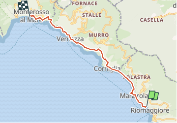
12,4 km | 23 km-effort
4h 26min
![](https://static1.geolcdn.com/siteimages/upload/files/16400158638029165_repeat_loop_refresh_sync_direction_icon.png)
Neen
![Tocht Stappen Vernazza - Fernacchi - manarola - Photo](https://media.geolcdn.com/t/375/260/ext.jpg?maxdim=2&url=https%3A%2F%2Fstatic1.geolcdn.com%2Fsiteimages%2Fupload%2Ffiles%2F1553511878bg_sport_marche.png)
![Stappen Stappen](https://static1.geolcdn.com/sitytour/trail-icons/101.png)
Fernacchi - manarola
Stappen
Gemakkelijk
(1)
Vernazza,
Ligurië,
La Spezia,
Italy
![](/images/other/stat-length.png)
5,8 km | 9,7 km-effort
2h 12min
![](https://static1.geolcdn.com/siteimages/upload/files/16400158638029165_repeat_loop_refresh_sync_direction_icon.png)
Neen
![Tocht Te voet La Spezia - Alta Via del Golfo: La Foce - Portovenere - Photo](https://media.geolcdn.com/t/375/260/ba716d0b-b060-4db4-8fd9-8ae9862dae50.jpeg&format=jpg&maxdim=2)
![Te voet Te voet](https://static1.geolcdn.com/sitytour/trail-icons/100.png)
Alta Via del Golfo: La Foce - Portovenere
Te voet
Medium
La Spezia,
Ligurië,
La Spezia,
Italy
![](/images/other/stat-length.png)
17,2 km | 26 km-effort
5h 54min
![](https://static1.geolcdn.com/siteimages/upload/files/16400158638029165_repeat_loop_refresh_sync_direction_icon.png)
Neen
![Tocht Te voet Riomaggiore - Alta Via delle 5 Terre: Portovenere - Monte Soviore - Foce di Dosso - Photo](https://media.geolcdn.com/t/375/260/456d2105-e49f-49c7-aec6-96ed27aa27d5.jpeg&format=jpg&maxdim=2)
![Te voet Te voet](https://static1.geolcdn.com/sitytour/trail-icons/100.png)
Alta Via delle 5 Terre: Portovenere - Monte Soviore - Foce di Dosso
Te voet
Medium
Riomaggiore,
Ligurië,
La Spezia,
Italy
![](/images/other/stat-length.png)
21 km | 30 km-effort
6h 53min
![](https://static1.geolcdn.com/siteimages/upload/files/16400158638029165_repeat_loop_refresh_sync_direction_icon.png)
Neen
![Tocht Te voet Riccò del Golfo di Spezia - S.Benedetto – Porcale -Codeglia – Carpena – Sella di Carpena - Photo](https://media.geolcdn.com/t/375/260/485ff305-713c-4bb1-8358-a3035ca2ede4.jpeg&format=jpg&maxdim=2)
![Te voet Te voet](https://static1.geolcdn.com/sitytour/trail-icons/100.png)
S.Benedetto – Porcale -Codeglia – Carpena – Sella di Carpena
Te voet
Gemakkelijk
Riccò del Golfo di Spezia,
Ligurië,
La Spezia,
Italy
![](/images/other/stat-length.png)
5,8 km | 9,8 km-effort
2h 13min
![](https://static1.geolcdn.com/siteimages/upload/files/16400158638029165_repeat_loop_refresh_sync_direction_icon.png)
Neen
![Tocht Te voet La Spezia - Fabiano – Mad.na dell'Olmo – Cà Pilloa – Sella Gesuela - Photo](https://media.geolcdn.com/t/375/260/64ba72ec-148f-4d90-a788-50975718b31b.jpeg&format=jpg&maxdim=2)
![Te voet Te voet](https://static1.geolcdn.com/sitytour/trail-icons/100.png)
Fabiano – Mad.na dell'Olmo – Cà Pilloa – Sella Gesuela
Te voet
Gemakkelijk
La Spezia,
Ligurië,
La Spezia,
Italy
![](/images/other/stat-length.png)
3,3 km | 5,1 km-effort
1h 10min
![](https://static1.geolcdn.com/siteimages/upload/files/16400158638029165_repeat_loop_refresh_sync_direction_icon.png)
Neen
![Tocht Te voet Vernazza - S.Bernardino – Murro sup. - Mad.di Reggio - Photo](https://media.geolcdn.com/t/375/260/27de0034-8b19-42a5-b4b2-0f604b22d803.jpeg&format=jpg&maxdim=2)
![Te voet Te voet](https://static1.geolcdn.com/sitytour/trail-icons/100.png)
S.Bernardino – Murro sup. - Mad.di Reggio
Te voet
Gemakkelijk
Vernazza,
Ligurië,
La Spezia,
Italy
![](/images/other/stat-length.png)
4,7 km | 7,4 km-effort
1h 40min
![](https://static1.geolcdn.com/siteimages/upload/files/16400158638029165_repeat_loop_refresh_sync_direction_icon.png)
Neen
![Tocht Te voet La Spezia - Pegazzano – Biassa – S.Antonio – Schiara - Photo](https://media.geolcdn.com/t/375/260/f5823fa0-46d8-488d-83ac-e0137eda51cf.jpeg&format=jpg&maxdim=2)
![Te voet Te voet](https://static1.geolcdn.com/sitytour/trail-icons/100.png)
Pegazzano – Biassa – S.Antonio – Schiara
Te voet
Gemakkelijk
La Spezia,
Ligurië,
La Spezia,
Italy
![](/images/other/stat-length.png)
6 km | 11,2 km-effort
2h 33min
![](https://static1.geolcdn.com/siteimages/upload/files/16400158638029165_repeat_loop_refresh_sync_direction_icon.png)
Neen
![Tocht Te voet Riomaggiore - Campiglia - Fossola - S.P. 370 Litoranea - Photo](https://media.geolcdn.com/t/375/260/e0935cd3-7ec4-41f0-b418-114728662a38.jpeg&format=jpg&maxdim=2)
![Te voet Te voet](https://static1.geolcdn.com/sitytour/trail-icons/100.png)
Campiglia - Fossola - S.P. 370 Litoranea
Te voet
Gemakkelijk
Riomaggiore,
Ligurië,
La Spezia,
Italy
![](/images/other/stat-length.png)
3,7 km | 6,3 km-effort
1h 26min
![](https://static1.geolcdn.com/siteimages/upload/files/16400158638029165_repeat_loop_refresh_sync_direction_icon.png)
Neen