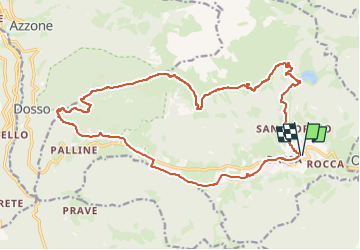
![](/images/other/stat-length.png)
![Tocht Te voet Borno - Sentiero del Paradiso - Photo](https://media.geolcdn.com/t/1900/400/3faf213d-3b46-4728-b8d4-0365a279735a.jpeg&format=pjpeg&maxdim=2)
Sentiero del Paradiso
SityTrail - itinéraires balisés pédestres
Tous les sentiers balisés d’Europe GUIDE+
![Lengte](/images/other/stat-length.png)
![Max. hoogte](https://static1.geolcdn.com/siteimages/upload/files/1508320355ic_sort_altitude_max_24dp.png)
![Positief hoogteverschil](https://static1.geolcdn.com/siteimages/upload/files/1508320355ic_sort_den_pos_24dp.png)
![Km-Effort](/images/other/stat-length.png)
![Min. hoogte](https://static1.geolcdn.com/siteimages/upload/files/1508320355ic_sort_altitude_min_24dp.png)
![Negatief hoogteverschil](https://static1.geolcdn.com/siteimages/upload/files/1508320355ic_sort_den_neg_24dp.png)
![Boucle](https://static1.geolcdn.com/siteimages/upload/files/16400158638029165_repeat_loop_refresh_sync_direction_icon.png)
![Te voet](https://static1.geolcdn.com/sitytour/trail-icons/100.png)
8h03
Moeilijkheid : Moeilijk
![Scan deze QR-code om de tocht te openen in de SityTrail-applicatie](https://capi.geolives.com/qq0zvz2zws4bq2lad0pu/sitytour/trails/3118894/qr.png?size=200)
Gratisgps-wandelapplicatie
Over ons
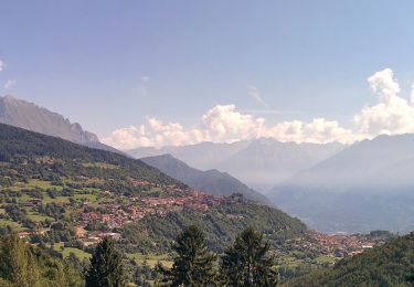
Tocht Te voet van 21 km beschikbaar op Lombardije, Brescia, Borno. Deze tocht wordt voorgesteld door SityTrail - itinéraires balisés pédestres.
Beschrijving
Descrizione del percorso: Dal centro del paese si sale subito per Via S. Fermo. Alle frecce direzionali a destra per Via Navertino. Tutta in leggera salita e asfaltata sino a raggiungere la località Navertino e poco oltre il ristorante omonimo. Due possibilità. A destra per il sentiero alternativo che arriva al Lago di Lova…
Website: https://corriintavola.wordpress.com/sentiero-del-paradiso/
Plaatsbepaling
Opmerkingen
Wandeltochten in de omgeving
![Tocht Te voet Borno - Sentiero delle pietre e degli Dei - Photo](https://media.geolcdn.com/t/375/260/3faf213d-3b46-4728-b8d4-0365a279735a.jpeg&format=jpg&maxdim=2)
![Te voet Te voet](https://static1.geolcdn.com/sitytour/trail-icons/100.png)
Te voet
![](/images/other/stat-length.png)
![](https://static1.geolcdn.com/siteimages/upload/files/16400158638029165_repeat_loop_refresh_sync_direction_icon.png)
![Tocht Te voet Borno - Trekking dell'Altopiano del Sole - Photo](https://media.geolcdn.com/t/375/260/726c06fc-babe-4740-aace-a8f70bd7bade.jpeg&format=jpg&maxdim=2)
![Te voet Te voet](https://static1.geolcdn.com/sitytour/trail-icons/100.png)
Te voet
![](/images/other/stat-length.png)
![](https://static1.geolcdn.com/siteimages/upload/files/16400158638029165_repeat_loop_refresh_sync_direction_icon.png)
![Tocht Te voet Lozio - Trekking tra malghe e menhir anello 7: Dosso della Sella - Malga Rò - Photo](https://media.geolcdn.com/t/375/260/147aa4f6-49a6-42db-91cc-527fd88592c9.jpeg&format=jpg&maxdim=2)
![Te voet Te voet](https://static1.geolcdn.com/sitytour/trail-icons/100.png)
Te voet
![](/images/other/stat-length.png)
![](https://static1.geolcdn.com/siteimages/upload/files/16400158638029165_repeat_loop_refresh_sync_direction_icon.png)
![Tocht Te voet Lozio - Brigata Fiamme Verdi Giacomo Cappellini - Photo](https://media.geolcdn.com/t/375/260/bc709bbb-34b3-4f38-abd5-16d0218cfdbd.jpeg&format=jpg&maxdim=2)
![Te voet Te voet](https://static1.geolcdn.com/sitytour/trail-icons/100.png)
Te voet
![](/images/other/stat-length.png)
![](https://static1.geolcdn.com/siteimages/upload/files/16400158638029165_repeat_loop_refresh_sync_direction_icon.png)
![Tocht Te voet Borno - Trekking tra malghe e menhir anello 8: Trekking menhir e incisioni rupestri - Photo](https://media.geolcdn.com/t/375/260/3faf213d-3b46-4728-b8d4-0365a279735a.jpeg&format=jpg&maxdim=2)
![Te voet Te voet](https://static1.geolcdn.com/sitytour/trail-icons/100.png)
Te voet
![](/images/other/stat-length.png)
![](https://static1.geolcdn.com/siteimages/upload/files/16400158638029165_repeat_loop_refresh_sync_direction_icon.png)
![Tocht Te voet Borno - Sentiero dei ciclamini - Photo](https://media.geolcdn.com/t/375/260/6caa6a28-6de0-4006-91a2-073524dfb97f.jpeg&format=jpg&maxdim=2)
![Te voet Te voet](https://static1.geolcdn.com/sitytour/trail-icons/100.png)
Te voet
![](/images/other/stat-length.png)
![](https://static1.geolcdn.com/siteimages/upload/files/16400158638029165_repeat_loop_refresh_sync_direction_icon.png)
![Tocht Te voet Borno - Sentiero del falco pellegrino - Photo](https://media.geolcdn.com/t/375/260/3faf213d-3b46-4728-b8d4-0365a279735a.jpeg&format=jpg&maxdim=2)
![Te voet Te voet](https://static1.geolcdn.com/sitytour/trail-icons/100.png)
Te voet
![](/images/other/stat-length.png)
![](https://static1.geolcdn.com/siteimages/upload/files/16400158638029165_repeat_loop_refresh_sync_direction_icon.png)
![Tocht Te voet Borno - Sentiero delle streghe - Photo](https://media.geolcdn.com/t/375/260/2f4cdf68-26b7-4b33-9a1d-91910de23095.jpeg&format=jpg&maxdim=2)
![Te voet Te voet](https://static1.geolcdn.com/sitytour/trail-icons/100.png)
Te voet
![](/images/other/stat-length.png)
![](https://static1.geolcdn.com/siteimages/upload/files/16400158638029165_repeat_loop_refresh_sync_direction_icon.png)
![Tocht Te voet Borno - Sentiero dei ruscelli canterini - Photo](https://media.geolcdn.com/t/375/260/826432c1-abe1-42db-a2fa-57f4ba06f92e.jpeg&format=jpg&maxdim=2)
![Te voet Te voet](https://static1.geolcdn.com/sitytour/trail-icons/100.png)
Te voet
![](/images/other/stat-length.png)
![](https://static1.geolcdn.com/siteimages/upload/files/16400158638029165_repeat_loop_refresh_sync_direction_icon.png)