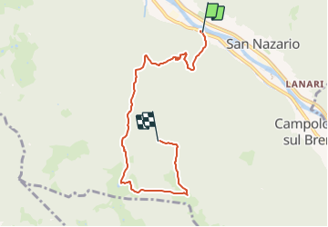
![](/images/other/stat-length.png)
![Tocht Te voet Valbrenta - Tovi - Valle Ranetta - C. Ralova - Monte Campolongo - Photo](https://media.geolcdn.com/t/1900/400/ef293c7f-6588-4629-b16e-9d8bb675a946.jpeg&format=pjpeg&maxdim=2)
Tovi - Valle Ranetta - C. Ralova - Monte Campolongo
SityTrail - itinéraires balisés pédestres
Tous les sentiers balisés d’Europe GUIDE+
![Lengte](/images/other/stat-length.png)
Lengte
6,4 km
![Max. hoogte](https://static1.geolcdn.com/siteimages/upload/files/1508320355ic_sort_altitude_max_24dp.png)
Max. hoogte
1136 m
![Positief hoogteverschil](https://static1.geolcdn.com/siteimages/upload/files/1508320355ic_sort_den_pos_24dp.png)
Positief hoogteverschil
999 m
![Km-Effort](/images/other/stat-length.png)
Km-Effort
16,5 km
![Min. hoogte](https://static1.geolcdn.com/siteimages/upload/files/1508320355ic_sort_altitude_min_24dp.png)
Min. hoogte
142 m
![Negatief hoogteverschil](https://static1.geolcdn.com/siteimages/upload/files/1508320355ic_sort_den_neg_24dp.png)
Negatief hoogteverschil
37 m
![Boucle](https://static1.geolcdn.com/siteimages/upload/files/16400158638029165_repeat_loop_refresh_sync_direction_icon.png)
Boucle
Neen
Markering
Datum van aanmaak :
2022-02-15 09:32:32.173
Laatste wijziging :
2022-03-01 07:04:34.065
![Te voet](https://static1.geolcdn.com/sitytour/trail-icons/100.png)
3h44
Moeilijkheid : Gemakkelijk
![Scan deze QR-code om de tocht te openen in de SityTrail-applicatie](https://capi.geolives.com/qq0zvz2zws4bq2lad0pu/sitytour/trails/3117351/qr.png?size=200)
Gratisgps-wandelapplicatie
Over ons
Tocht Te voet van 6,4 km beschikbaar op Veneto, Vicenza, Valbrenta. Deze tocht wordt voorgesteld door SityTrail - itinéraires balisés pédestres.
Beschrijving
Trail created by Campolongo sul Brenta.
Symbol: 769 on white red flag
Website: http://www.caimarostica.it
Plaatsbepaling
Land:
Italy
Regio :
Veneto
Departement/Provincie :
Vicenza
Gemeente :
Valbrenta
Locatie:
Unknown
Vertrek:(Dec)
Vertrek:(UTM)
708036 ; 5079930 (32T) N.
Opmerkingen
Wandeltochten in de omgeving
![Tocht Te voet Solagna - IT-940 - Photo](https://media.geolcdn.com/t/375/260/0f4ab9ed-0de7-4cf1-8475-a5e1dbf7d1b5.jpeg&format=jpg&maxdim=2)
![Te voet Te voet](https://static1.geolcdn.com/sitytour/trail-icons/100.png)
![Tocht Te voet Valbrenta - Oliero di Sotto - Le Pozzette - Col d'Astiago - Photo](https://media.geolcdn.com/t/375/260/ef293c7f-6588-4629-b16e-9d8bb675a946.jpeg&format=jpg&maxdim=2)
![Te voet Te voet](https://static1.geolcdn.com/sitytour/trail-icons/100.png)
Oliero di Sotto - Le Pozzette - Col d'Astiago
Te voet
Gemakkelijk
Valbrenta,
Veneto,
Vicenza,
Italy
![](/images/other/stat-length.png)
5 km | 15,8 km-effort
3h 35min
![](https://static1.geolcdn.com/siteimages/upload/files/16400158638029165_repeat_loop_refresh_sync_direction_icon.png)
Neen
![Tocht Te voet Valbrenta - Oliero di Sopra - Le Pozzette - Col d'Astiago - Photo](https://media.geolcdn.com/t/375/260/ef293c7f-6588-4629-b16e-9d8bb675a946.jpeg&format=jpg&maxdim=2)
![Te voet Te voet](https://static1.geolcdn.com/sitytour/trail-icons/100.png)
Oliero di Sopra - Le Pozzette - Col d'Astiago
Te voet
Gemakkelijk
Valbrenta,
Veneto,
Vicenza,
Italy
![](/images/other/stat-length.png)
4,5 km | 15,2 km-effort
3h 27min
![](https://static1.geolcdn.com/siteimages/upload/files/16400158638029165_repeat_loop_refresh_sync_direction_icon.png)
Neen
![Tocht Te voet Valbrenta - Sannazara - Photo](https://media.geolcdn.com/t/375/260/5f929a44-1c04-46c4-b850-8fabf6402c15.jpeg&format=jpg&maxdim=2)
![Te voet Te voet](https://static1.geolcdn.com/sitytour/trail-icons/100.png)
Sannazara
Te voet
Gemakkelijk
Valbrenta,
Veneto,
Vicenza,
Italy
![](/images/other/stat-length.png)
4,3 km | 15,8 km-effort
3h 35min
![](https://static1.geolcdn.com/siteimages/upload/files/16400158638029165_repeat_loop_refresh_sync_direction_icon.png)
Neen
![Tocht Te voet Valbrenta - Moschina - Photo](https://media.geolcdn.com/t/375/260/0f4ab9ed-0de7-4cf1-8475-a5e1dbf7d1b5.jpeg&format=jpg&maxdim=2)
![Te voet Te voet](https://static1.geolcdn.com/sitytour/trail-icons/100.png)
Moschina
Te voet
Gemakkelijk
Valbrenta,
Veneto,
Vicenza,
Italy
![](/images/other/stat-length.png)
4,8 km | 15,9 km-effort
3h 37min
![](https://static1.geolcdn.com/siteimages/upload/files/16400158638029165_repeat_loop_refresh_sync_direction_icon.png)
Neen
![Tocht Te voet Valbrenta - Mori (Valstagna) - Monte Cornone - Sasso Rosso - Photo](https://media.geolcdn.com/t/375/260/406bf2da-423c-495a-b148-f53a1b9f8946.jpeg&format=jpg&maxdim=2)
![Te voet Te voet](https://static1.geolcdn.com/sitytour/trail-icons/100.png)
Mori (Valstagna) - Monte Cornone - Sasso Rosso
Te voet
Gemakkelijk
Valbrenta,
Veneto,
Vicenza,
Italy
![](/images/other/stat-length.png)
3,5 km | 13,7 km-effort
3h 6min
![](https://static1.geolcdn.com/siteimages/upload/files/16400158638029165_repeat_loop_refresh_sync_direction_icon.png)
Neen
![Tocht Te voet Valbrenta - Campolongo sul Brenta - Casare di Campolongo - Monte Campolongo - Photo](https://media.geolcdn.com/t/375/260/019c7c09-5872-4fe3-b255-5652a802112b.jpeg&format=jpg&maxdim=2)
![Te voet Te voet](https://static1.geolcdn.com/sitytour/trail-icons/100.png)
Campolongo sul Brenta - Casare di Campolongo - Monte Campolongo
Te voet
Gemakkelijk
Valbrenta,
Veneto,
Vicenza,
Italy
![](/images/other/stat-length.png)
5,7 km | 15,8 km-effort
3h 35min
![](https://static1.geolcdn.com/siteimages/upload/files/16400158638029165_repeat_loop_refresh_sync_direction_icon.png)
Neen
![Tocht Te voet Bassano del Grappa - Campese - Bocchetta Campesana - Monte Caina - Photo](https://media.geolcdn.com/t/375/260/b5114b3f-7e87-431e-a5a2-28207aeb60f1.jpeg&format=jpg&maxdim=2)
![Te voet Te voet](https://static1.geolcdn.com/sitytour/trail-icons/100.png)
Campese - Bocchetta Campesana - Monte Caina
Te voet
Gemakkelijk
Bassano del Grappa,
Veneto,
Vicenza,
Italy
![](/images/other/stat-length.png)
4,4 km | 13,4 km-effort
3h 2min
![](https://static1.geolcdn.com/siteimages/upload/files/16400158638029165_repeat_loop_refresh_sync_direction_icon.png)
Neen
![Tocht Te voet Lusiana Conco - Anello dei Tre Confini - Photo](https://media.geolcdn.com/t/375/260/ext.jpg?maxdim=2&url=https%3A%2F%2Fstatic1.geolcdn.com%2Fsiteimages%2Fupload%2Ffiles%2F1545311037marcheuse_200dpi.jpg)
![Te voet Te voet](https://static1.geolcdn.com/sitytour/trail-icons/100.png)
Anello dei Tre Confini
Te voet
Medium
Lusiana Conco,
Veneto,
Vicenza,
Italy
![](/images/other/stat-length.png)
13,7 km | 21 km-effort
4h 48min
![](https://static1.geolcdn.com/siteimages/upload/files/16400158638029165_repeat_loop_refresh_sync_direction_icon.png)
Neen