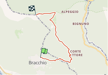
![](/images/other/stat-length.png)
![Tocht Te voet Mergozzo - A54 - Bracchio - Cappella di Erfo - Monte Faiè - Photo](https://media.geolcdn.com/t/1900/400/3eff084a-3b3f-4519-be3c-e424ea270e12.jpeg&format=pjpeg&maxdim=2)
A54 - Bracchio - Cappella di Erfo - Monte Faiè
SityTrail - itinéraires balisés pédestres
Tous les sentiers balisés d’Europe GUIDE+
![Lengte](/images/other/stat-length.png)
![Max. hoogte](https://static1.geolcdn.com/siteimages/upload/files/1508320355ic_sort_altitude_max_24dp.png)
![Positief hoogteverschil](https://static1.geolcdn.com/siteimages/upload/files/1508320355ic_sort_den_pos_24dp.png)
![Km-Effort](/images/other/stat-length.png)
![Min. hoogte](https://static1.geolcdn.com/siteimages/upload/files/1508320355ic_sort_altitude_min_24dp.png)
![Negatief hoogteverschil](https://static1.geolcdn.com/siteimages/upload/files/1508320355ic_sort_den_neg_24dp.png)
![Boucle](https://static1.geolcdn.com/siteimages/upload/files/16400158638029165_repeat_loop_refresh_sync_direction_icon.png)
![Te voet](https://static1.geolcdn.com/sitytour/trail-icons/100.png)
3h32
Moeilijkheid : Gemakkelijk
![Scan deze QR-code om de tocht te openen in de SityTrail-applicatie](https://capi.geolives.com/qq0zvz2zws4bq2lad0pu/sitytour/trails/3116483/qr.png?size=200)
Gratisgps-wandelapplicatie
Over ons
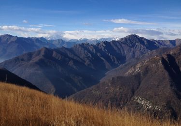
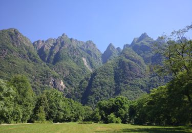
Tocht Te voet van 5,5 km beschikbaar op Piëmont, Verbano-Cusio-Ossola, Mergozzo. Deze tocht wordt voorgesteld door SityTrail - itinéraires balisés pédestres.
Beschrijving
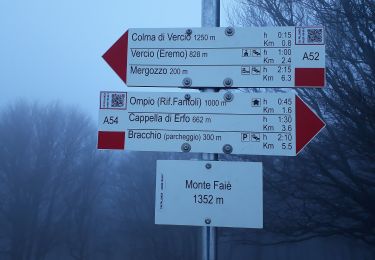
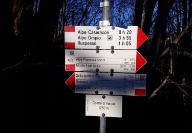
Trail created by CAI Pallanza.
Relation with photos (click on → Web site) mantained by Danilo (CAI Pallanza)
Symbol: A54 on white red flag
Website: http://www.cai-pallanza.it/sentieristica
Plaatsbepaling
Opmerkingen
Wandeltochten in de omgeving
![Tocht Te voet Mergozzo - A58 - Mergozzo - Linea Cadorna - Mont'Orfano vetta - Photo](https://media.geolcdn.com/t/375/260/e16f555f-fd2b-4364-81d2-f671e285fe6d.jpeg&format=jpg&maxdim=2)
![Te voet Te voet](https://static1.geolcdn.com/sitytour/trail-icons/100.png)
Te voet
![](/images/other/stat-length.png)
![](https://static1.geolcdn.com/siteimages/upload/files/16400158638029165_repeat_loop_refresh_sync_direction_icon.png)
![Tocht Te voet Mergozzo - A56 - Mergozzo - Sentiero Azzurro - Mont'Orfano vetta - Photo](https://media.geolcdn.com/t/375/260/c8f9c358-74cd-4027-9c39-0d06a257957f.jpeg&format=jpg&maxdim=2)
![Te voet Te voet](https://static1.geolcdn.com/sitytour/trail-icons/100.png)
Te voet
![](/images/other/stat-length.png)
![](https://static1.geolcdn.com/siteimages/upload/files/16400158638029165_repeat_loop_refresh_sync_direction_icon.png)
![Tocht Te voet Cossogno - P11 - Cicogna - Cima Sasso - Photo](https://media.geolcdn.com/t/375/260/8c309f6c-514c-46f8-8058-b7941f6c0cf2.jpeg&format=jpg&maxdim=2)
![Te voet Te voet](https://static1.geolcdn.com/sitytour/trail-icons/100.png)
Te voet
![](/images/other/stat-length.png)
![](https://static1.geolcdn.com/siteimages/upload/files/16400158638029165_repeat_loop_refresh_sync_direction_icon.png)
![Tocht Te voet Cossogno - P06 - Cicogna - Varola - Curgei - Pizzo Pernice - Photo](https://media.geolcdn.com/t/375/260/7d513a9c-ccc2-4557-8e64-77b34efc7a26.jpeg&format=jpg&maxdim=2)
![Te voet Te voet](https://static1.geolcdn.com/sitytour/trail-icons/100.png)
Te voet
![](/images/other/stat-length.png)
![](https://static1.geolcdn.com/siteimages/upload/files/16400158638029165_repeat_loop_refresh_sync_direction_icon.png)
![Tocht Te voet Cossogno - BOVE - Sentiero BOVE - Photo](https://media.geolcdn.com/t/375/260/5989daae-06f9-48e2-a227-1f933d7bb9b9.jpeg&format=jpg&maxdim=2)
![Te voet Te voet](https://static1.geolcdn.com/sitytour/trail-icons/100.png)
Te voet
![](/images/other/stat-length.png)
![](https://static1.geolcdn.com/siteimages/upload/files/16400158638029165_repeat_loop_refresh_sync_direction_icon.png)
![Tocht Te voet Cossogno - P08 - Cicogna -Tregugno - la Soliva - Pian Cavallone - Photo](https://media.geolcdn.com/t/375/260/4faaaeae-ca6f-4975-9b8e-9c5af490cfb8.jpeg&format=jpg&maxdim=2)
![Te voet Te voet](https://static1.geolcdn.com/sitytour/trail-icons/100.png)
Te voet
![](/images/other/stat-length.png)
![](https://static1.geolcdn.com/siteimages/upload/files/16400158638029165_repeat_loop_refresh_sync_direction_icon.png)
![Tocht Te voet San Bernardino Verbano - X06 - Orfalecchio - Alpe Rodugno - Bocchetta di Saltir - Alpe Corte - Photo](https://media.geolcdn.com/t/375/260/8ba17b89-f42f-40ae-8812-d1c913b3b64a.jpeg&format=jpg&maxdim=2)
![Te voet Te voet](https://static1.geolcdn.com/sitytour/trail-icons/100.png)
Te voet
![](/images/other/stat-length.png)
![](https://static1.geolcdn.com/siteimages/upload/files/16400158638029165_repeat_loop_refresh_sync_direction_icon.png)
![Tocht Te voet San Bernardino Verbano - P07b - bivio A54 in località La Croce (Ompio) - Corte Buè - Photo](https://media.geolcdn.com/t/375/260/5cf88269-4b68-49d7-8b88-8a773a49ff83.jpeg&format=jpg&maxdim=2)
![Te voet Te voet](https://static1.geolcdn.com/sitytour/trail-icons/100.png)
Te voet
![](/images/other/stat-length.png)
![](https://static1.geolcdn.com/siteimages/upload/files/16400158638029165_repeat_loop_refresh_sync_direction_icon.png)
![Tocht Te voet San Bernardino Verbano - X02 - Corte Buè - Orfalecchio per la Val Foiera - Photo](https://media.geolcdn.com/t/375/260/40ae59af-b59c-4322-a08d-69c6339edc5b.jpeg&format=jpg&maxdim=2)
![Te voet Te voet](https://static1.geolcdn.com/sitytour/trail-icons/100.png)
Te voet
![](/images/other/stat-length.png)
![](https://static1.geolcdn.com/siteimages/upload/files/16400158638029165_repeat_loop_refresh_sync_direction_icon.png)