![](/images/other/stat-length.png)
![Tocht Te voet Sainte-Opportune-la-Mare - Chemin pédestre de l'Allée des Granges - Photo](https://media.geolcdn.com/t/1900/400/7933c4e8-7afb-4170-943c-36ad14b0db16.jpeg&format=pjpeg&maxdim=2)
Chemin pédestre de l'Allée des Granges
SityTrail - itinéraires balisés pédestres
Tous les sentiers balisés d’Europe GUIDE+
![Lengte](/images/other/stat-length.png)
Lengte
6,4 km
![Max. hoogte](https://static1.geolcdn.com/siteimages/upload/files/1508320355ic_sort_altitude_max_24dp.png)
Max. hoogte
125 m
![Positief hoogteverschil](https://static1.geolcdn.com/siteimages/upload/files/1508320355ic_sort_den_pos_24dp.png)
Positief hoogteverschil
124 m
![Km-Effort](/images/other/stat-length.png)
Km-Effort
8,1 km
![Min. hoogte](https://static1.geolcdn.com/siteimages/upload/files/1508320355ic_sort_altitude_min_24dp.png)
Min. hoogte
7 m
![Negatief hoogteverschil](https://static1.geolcdn.com/siteimages/upload/files/1508320355ic_sort_den_neg_24dp.png)
Negatief hoogteverschil
124 m
![Boucle](https://static1.geolcdn.com/siteimages/upload/files/16400158638029165_repeat_loop_refresh_sync_direction_icon.png)
Boucle
Ja
Markering
Datum van aanmaak :
2022-02-15 06:12:46.453
Laatste wijziging :
2022-03-02 14:50:43.762
![Te voet](https://static1.geolcdn.com/sitytour/trail-icons/100.png)
1h49
Moeilijkheid : Gemakkelijk
![Scan deze QR-code om de tocht te openen in de SityTrail-applicatie](https://capi.geolives.com/qq0zvz2zws4bq2lad0pu/sitytour/trails/3116398/qr.png?size=200)
Gratisgps-wandelapplicatie
Over ons
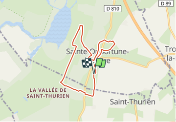
Tocht Te voet van 6,4 km beschikbaar op Normandië, Eure, Sainte-Opportune-la-Mare. Deze tocht wordt voorgesteld door SityTrail - itinéraires balisés pédestres.
Beschrijving
Symbol: blue_bar
Plaatsbepaling
Land:
France
Regio :
Normandië
Departement/Provincie :
Eure
Gemeente :
Sainte-Opportune-la-Mare
Locatie:
Unknown
Vertrek:(Dec)
Vertrek:(UTM)
321739 ; 5476354 (31U) N.
Opmerkingen
Wandeltochten in de omgeving
![Tocht Stappen Trouville-la-Haule - Randonnée à Trouville la Haule - Photo](https://media.geolcdn.com/t/375/260/ext.jpg?maxdim=2&url=https%3A%2F%2Fservices.sitytrail.com%2FGeolivesWS%2FDownloadMedia.ashx%3FTrailID%3D107363%26Media%3D12260_1.jpg)
![Stappen Stappen](https://static1.geolcdn.com/sitytour/trail-icons/101.png)
Randonnée à Trouville la Haule
Stappen
Medium
(1)
Trouville-la-Haule,
Normandië,
Eure,
France
![](/images/other/stat-length.png)
14,6 km | 18,6 km-effort
3h 19min
![](https://static1.geolcdn.com/siteimages/upload/files/16400158638029165_repeat_loop_refresh_sync_direction_icon.png)
Ja
![Tocht Stappen Bouquelon - Boucle de Bouquelon V2 variante - Photo](https://media.geolcdn.com/t/375/260/ext.jpg?maxdim=2&url=https%3A%2F%2Fstatic1.geolcdn.com%2Fsiteimages%2Fupload%2Ffiles%2F1553511878bg_sport_marche.png)
![Stappen Stappen](https://static1.geolcdn.com/sitytour/trail-icons/101.png)
Boucle de Bouquelon V2 variante
Stappen
Medium
(1)
Bouquelon,
Normandië,
Eure,
France
![](/images/other/stat-length.png)
9,1 km | 11,1 km-effort
2h 31min
![](https://static1.geolcdn.com/siteimages/upload/files/16400158638029165_repeat_loop_refresh_sync_direction_icon.png)
Ja
![Tocht Stappen Bouquelon - Boucle de Bouquelon V1 - Photo](https://media.geolcdn.com/t/375/260/ext.jpg?maxdim=2&url=https%3A%2F%2Fstatic1.geolcdn.com%2Fsiteimages%2Fupload%2Ffiles%2F1553511878bg_sport_marche.png)
![Stappen Stappen](https://static1.geolcdn.com/sitytour/trail-icons/101.png)
Boucle de Bouquelon V1
Stappen
Moeilijk
(1)
Bouquelon,
Normandië,
Eure,
France
![](/images/other/stat-length.png)
13,3 km | 16,6 km-effort
3h 46min
![](https://static1.geolcdn.com/siteimages/upload/files/16400158638029165_repeat_loop_refresh_sync_direction_icon.png)
Ja
![Tocht Stappen Bouquelon - Boucle de Bouquelon V2 - Photo](https://media.geolcdn.com/t/375/260/ext.jpg?maxdim=2&url=https%3A%2F%2Fstatic1.geolcdn.com%2Fsiteimages%2Fupload%2Ffiles%2F1553511878bg_sport_marche.png)
![Stappen Stappen](https://static1.geolcdn.com/sitytour/trail-icons/101.png)
Boucle de Bouquelon V2
Stappen
Medium
(1)
Bouquelon,
Normandië,
Eure,
France
![](/images/other/stat-length.png)
9,4 km | 11,4 km-effort
2h 35min
![](https://static1.geolcdn.com/siteimages/upload/files/16400158638029165_repeat_loop_refresh_sync_direction_icon.png)
Ja
![Tocht Stappen Trouville-la-Haule - Trouville la Haule . Chemin du Courval - Photo](https://media.geolcdn.com/t/375/260/b18ccded-32f9-499d-b58c-a18fcc72914b.jpg&format=jpg&maxdim=2)
![Stappen Stappen](https://static1.geolcdn.com/sitytour/trail-icons/101.png)
Trouville la Haule . Chemin du Courval
Stappen
Moeilijk
(1)
Trouville-la-Haule,
Normandië,
Eure,
France
![](/images/other/stat-length.png)
11,8 km | 14,5 km-effort
3h 3min
![](https://static1.geolcdn.com/siteimages/upload/files/16400158638029165_repeat_loop_refresh_sync_direction_icon.png)
Ja
![Tocht Stappen Le Perrey - chemin des Têtards - Photo](https://media.geolcdn.com/t/375/260/ext.jpg?maxdim=2&url=https%3A%2F%2Fservices.sitytrail.com%2FGeolivesWS%2FDownloadMedia.ashx%3FTrailID%3D487376%26Media%3Dfix__20151030163357.jpg)
![Stappen Stappen](https://static1.geolcdn.com/sitytour/trail-icons/101.png)
chemin des Têtards
Stappen
Medium
Le Perrey,
Normandië,
Eure,
France
![](/images/other/stat-length.png)
7,8 km | 9,2 km-effort
2h 21min
![](https://static1.geolcdn.com/siteimages/upload/files/16400158638029165_repeat_loop_refresh_sync_direction_icon.png)
Ja
![Tocht Stappen Bouquelon - La Route des chaumières - Photo](https://media.geolcdn.com/t/375/260/a66cd54d-1b43-4979-8d4d-f7a216d7d650.jpg&format=jpg&maxdim=2)
![Stappen Stappen](https://static1.geolcdn.com/sitytour/trail-icons/101.png)
La Route des chaumières
Stappen
Medium
Bouquelon,
Normandië,
Eure,
France
![](/images/other/stat-length.png)
9,3 km | 11,4 km-effort
2h 58min
![](https://static1.geolcdn.com/siteimages/upload/files/16400158638029165_repeat_loop_refresh_sync_direction_icon.png)
Ja
![Tocht Stappen Bouquelon - Bouquelon - Photo](https://media.geolcdn.com/t/375/260/ext.jpg?maxdim=2&url=https%3A%2F%2Fservices.sitytrail.com%2FGeolivesWS%2FDownloadMedia.ashx%3FTrailID%3D1030710%26Media%3Dfix__20180829152015.jpg)
![Stappen Stappen](https://static1.geolcdn.com/sitytour/trail-icons/101.png)
Bouquelon
Stappen
Heel gemakkelijk
Bouquelon,
Normandië,
Eure,
France
![](/images/other/stat-length.png)
13,2 km | 16,4 km-effort
3h 25min
![](https://static1.geolcdn.com/siteimages/upload/files/16400158638029165_repeat_loop_refresh_sync_direction_icon.png)
Ja
![Tocht Stappen Bouquelon - Le phare de la Roque - Bouquelon - Photo](https://media.geolcdn.com/t/375/260/ext.jpg?maxdim=2&url=https%3A%2F%2Fservices.sitytrail.com%2FGeolivesWS%2FDownloadMedia.ashx%3FTrailID%3D118767%26Media%3D12964_1.jpg)
![Stappen Stappen](https://static1.geolcdn.com/sitytour/trail-icons/101.png)
Le phare de la Roque - Bouquelon
Stappen
Medium
Bouquelon,
Normandië,
Eure,
France
![](/images/other/stat-length.png)
19,4 km | 24 km-effort
4h 0min
![](https://static1.geolcdn.com/siteimages/upload/files/16400158638029165_repeat_loop_refresh_sync_direction_icon.png)
Ja