Tocht Te voet Schnals - Senales - Seerundweg - Photo

Tous les sentiers balisés d’Europe PRO

© OpenStreetMap contributors
Lengte
Lengte
3,1 km
Max. hoogte
Max. hoogte
1752 m
Positief hoogteverschil
93 m
Km-Effort
Km-Effort  
4,6 km
Min. hoogte
Min. hoogte
1668 m
Negatief hoogteverschil
152 m
Boucle
Boucle
Neen
Markering
Markering
Datum van aanmaak :
2022-02-15 05:41:28.461
Laatste wijziging :
2022-03-01 03:58:58.7

(0 Bericht)

Te voet
Te voet
1h02
Moeilijkheid : Gemakkelijk

Scan deze QR-code om de tocht te openen in de SityTrail-applicatie

Gratisgps-wandelapplicatie

Logo SityTrail SityTrail

IGN / Geografische instituten

SityTrail uit de App Store downloaden SityTrail uit Google Play downloaden

Logo SityTrail SityTrail World

De wereld gaat voor u open

SityTrail uit de App Store downloaden SityTrail uit Google Play downloaden SityTrail op Huawei AppGallery downloaden

Over ons

Tocht Te voet van 3,1 km beschikbaar op Trento-Zuid-Tirol, Bolzano - Bozen, Schnals - Senales. Deze tocht wordt voorgesteld door SityTrail - itinéraires balisés pédestres.

Beschrijving

Symbol: blauer Fleck im geschwungenen schwarzem S in schwarzem Rahmen, darüber und darunter ein roter Streifen

Foto's

Plaatsbepaling

Land:
Italy
Regio :
Trento-Zuid-Tirol
Departement/Provincie :
Bolzano - Bozen
Gemeente :
Schnals - Senales
Locatie:
Unknown
Vertrek:(UTM)
638750 ; 5176862 (32T) N.

Wandeltochten in de omgeving

Tocht Te voet Schnals - Senales - IT-7 - Photo
Te voet
PRO

Te voet

Gemakkelijk
Schnals - Senales, Trento-Zuid-Tirol, Bolzano - Bozen, Italy
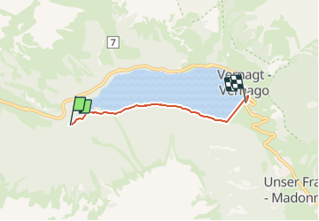
4,9 km | 7,1 km-effort
1h 37min
Neen
Tocht Te voet Schnals - Senales - 13 - Photo
Te voet
PRO

Te voet

Gemakkelijk
Schnals - Senales, Trento-Zuid-Tirol, Bolzano - Bozen, Italy
7 km | 13,9 km-effort
3h 9min
Neen
Tocht Te voet Schnals - Senales - 5 - Photo
Te voet
PRO

Te voet

Gemakkelijk
Schnals - Senales, Trento-Zuid-Tirol, Bolzano - Bozen, Italy
5,2 km | 8,7 km-effort
1h 58min
Neen


Sluiten
Mijn abonnementen