![](/images/other/stat-length.png)
![Tocht Te voet Sežana - Pot Sonje Mašera - Photo](https://media.geolcdn.com/t/1900/400/ext.pjpeg?maxdim=2&url=https%3A%2F%2Fstatic1.geolcdn.com%2Fsiteimages%2Fupload%2Ffiles%2F1545311037marcheuse_200dpi.jpg)
Pot Sonje Mašera
SityTrail - itinéraires balisés pédestres
Tous les sentiers balisés d’Europe GUIDE+
![Lengte](/images/other/stat-length.png)
Lengte
14,4 km
![Max. hoogte](https://static1.geolcdn.com/siteimages/upload/files/1508320355ic_sort_altitude_max_24dp.png)
Max. hoogte
420 m
![Positief hoogteverschil](https://static1.geolcdn.com/siteimages/upload/files/1508320355ic_sort_den_pos_24dp.png)
Positief hoogteverschil
211 m
![Km-Effort](/images/other/stat-length.png)
Km-Effort
18,5 km
![Min. hoogte](https://static1.geolcdn.com/siteimages/upload/files/1508320355ic_sort_altitude_min_24dp.png)
Min. hoogte
1 m
![Negatief hoogteverschil](https://static1.geolcdn.com/siteimages/upload/files/1508320355ic_sort_den_neg_24dp.png)
Negatief hoogteverschil
588 m
![Boucle](https://static1.geolcdn.com/siteimages/upload/files/16400158638029165_repeat_loop_refresh_sync_direction_icon.png)
Boucle
Neen
Markering
Datum van aanmaak :
2022-02-15 01:35:20.083
Laatste wijziging :
2022-02-15 01:35:20.083
![Te voet](https://static1.geolcdn.com/sitytour/trail-icons/100.png)
4h12
Moeilijkheid : Gemakkelijk
![Scan deze QR-code om de tocht te openen in de SityTrail-applicatie](https://capi.geolives.com/qq0zvz2zws4bq2lad0pu/sitytour/trails/3113460/qr.png?size=200)
Gratisgps-wandelapplicatie
Over ons
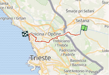
Tocht Te voet van 14,4 km beschikbaar op Onbekend, Onbekend, Sežana. Deze tocht wordt voorgesteld door SityTrail - itinéraires balisés pédestres.
Beschrijving
Trail created by Slovensko planinsko društvo Trst (SPDT).
Website: http://www.spdt.org/
Plaatsbepaling
Land:
Slovenia
Regio :
Onbekend
Departement/Provincie :
Onbekend
Gemeente :
Sežana
Locatie:
Unknown
Vertrek:(Dec)
Vertrek:(UTM)
411812 ; 5059842 (33T) N.
Opmerkingen
Wandeltochten in de omgeving
![Tocht Te voet Sežana - Kosovelova pot - Photo](https://media.geolcdn.com/t/375/260/cecaba7e-a1ce-40f1-8682-1487b47183a0.jpeg&format=jpg&maxdim=2)
![Te voet Te voet](https://static1.geolcdn.com/sitytour/trail-icons/100.png)
Kosovelova pot
Te voet
Gemakkelijk
Sežana,
Onbekend,
Onbekend,
Slovenia
![](/images/other/stat-length.png)
8,8 km | 11,3 km-effort
2h 34min
![](https://static1.geolcdn.com/siteimages/upload/files/16400158638029165_repeat_loop_refresh_sync_direction_icon.png)
Neen
![Tocht Te voet Triëst - (SI A26) Basovizza - Centro visite Val Rosandra - Photo](https://media.geolcdn.com/t/375/260/e4db50b9-515f-4542-9739-f4df59c3b8b4.jpeg&format=jpg&maxdim=2)
![Te voet Te voet](https://static1.geolcdn.com/sitytour/trail-icons/100.png)
(SI A26) Basovizza - Centro visite Val Rosandra
Te voet
Gemakkelijk
Triëst,
Friuli-Venezia Giulia,
Onbekend,
Italy
![](/images/other/stat-length.png)
10,3 km | 13,2 km-effort
3h 0min
![](https://static1.geolcdn.com/siteimages/upload/files/16400158638029165_repeat_loop_refresh_sync_direction_icon.png)
Neen
![Tocht Te voet Triëst - IT-17 - Photo](https://media.geolcdn.com/t/375/260/8b149020-f42f-4138-a3fc-743a3ad8d7af.jpeg&format=jpg&maxdim=2)
![Te voet Te voet](https://static1.geolcdn.com/sitytour/trail-icons/100.png)
IT-17
Te voet
Gemakkelijk
Triëst,
Friuli-Venezia Giulia,
Onbekend,
Italy
![](/images/other/stat-length.png)
7,1 km | 9,3 km-effort
2h 6min
![](https://static1.geolcdn.com/siteimages/upload/files/16400158638029165_repeat_loop_refresh_sync_direction_icon.png)
Neen
![Tocht Te voet Triëst - Pohod po pečinah - Photo](https://media.geolcdn.com/t/375/260/c3572ffa-4500-4060-933d-6cc467b1b700.jpeg&format=jpg&maxdim=2)
![Te voet Te voet](https://static1.geolcdn.com/sitytour/trail-icons/100.png)
Pohod po pečinah
Te voet
Gemakkelijk
Triëst,
Friuli-Venezia Giulia,
Onbekend,
Italy
![](/images/other/stat-length.png)
14,3 km | 17,3 km-effort
3h 55min
![](https://static1.geolcdn.com/siteimages/upload/files/16400158638029165_repeat_loop_refresh_sync_direction_icon.png)
Neen
![Tocht Andere activiteiten Sežana - Povir - Photo](https://media.geolcdn.com/t/375/260/ext.jpg?maxdim=2&url=https%3A%2F%2Fstatic1.geolcdn.com%2Fsiteimages%2Fupload%2Ffiles%2F1545311037marcheuse_200dpi.jpg)
![Andere activiteiten Andere activiteiten](https://static1.geolcdn.com/sitytour/trail-icons/900.png)
Povir
Andere activiteiten
Moeilijk
Sežana,
Onbekend,
Onbekend,
Slovenia
![](/images/other/stat-length.png)
8,9 km | 12,6 km-effort
2h 49min
![](https://static1.geolcdn.com/siteimages/upload/files/16400158638029165_repeat_loop_refresh_sync_direction_icon.png)
Ja