![](/images/other/stat-length.png)
![Tocht Te voet Triëst - IT-2 - Photo](https://media.geolcdn.com/t/1900/400/798dfb9f-7a91-4fb1-b95a-f5e0edcbcebb.jpeg&format=pjpeg&maxdim=2)
IT-2
SityTrail - itinéraires balisés pédestres
Tous les sentiers balisés d’Europe GUIDE+
![Lengte](/images/other/stat-length.png)
![Max. hoogte](https://static1.geolcdn.com/siteimages/upload/files/1508320355ic_sort_altitude_max_24dp.png)
![Positief hoogteverschil](https://static1.geolcdn.com/siteimages/upload/files/1508320355ic_sort_den_pos_24dp.png)
![Km-Effort](/images/other/stat-length.png)
![Min. hoogte](https://static1.geolcdn.com/siteimages/upload/files/1508320355ic_sort_altitude_min_24dp.png)
![Negatief hoogteverschil](https://static1.geolcdn.com/siteimages/upload/files/1508320355ic_sort_den_neg_24dp.png)
![Boucle](https://static1.geolcdn.com/siteimages/upload/files/16400158638029165_repeat_loop_refresh_sync_direction_icon.png)
![Te voet](https://static1.geolcdn.com/sitytour/trail-icons/100.png)
2h54
Moeilijkheid : Gemakkelijk
![Scan deze QR-code om de tocht te openen in de SityTrail-applicatie](https://capi.geolives.com/qq0zvz2zws4bq2lad0pu/sitytour/trails/3113094/qr.png?size=200)
Gratisgps-wandelapplicatie
Over ons
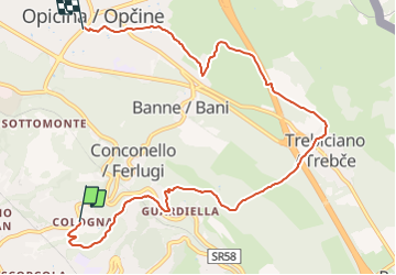
Tocht Te voet van 9,1 km beschikbaar op Friuli-Venezia Giulia, Onbekend, Triëst. Deze tocht wordt voorgesteld door SityTrail - itinéraires balisés pédestres.
Beschrijving
Trail created by Commissione Giulio Carnica Sentieri, Rifugi e Opere Alpine.
Opicina - Trebiciano - Sella Marchesetti - Parco Villa Giulia - Cologna
Symbol: 2 on white red flag
Website: http://www.cai-fvg.it/sentieri-cai-fvg/sentieri-cai-fvg-settore-0-carso/
Plaatsbepaling
Opmerkingen
Wandeltochten in de omgeving
![Tocht Te voet Triëst - IT-26 - Photo](https://media.geolcdn.com/t/375/260/f5edd303-9734-4978-b920-7283e0cdb8f4.jpeg&format=jpg&maxdim=2)
![Te voet Te voet](https://static1.geolcdn.com/sitytour/trail-icons/100.png)
Te voet
![](/images/other/stat-length.png)
![](https://static1.geolcdn.com/siteimages/upload/files/16400158638029165_repeat_loop_refresh_sync_direction_icon.png)
![Tocht Te voet Triëst - IT-43 - Photo](https://media.geolcdn.com/t/375/260/48d0de8f-089a-42fc-89c5-05dbbe87122f.jpeg&format=jpg&maxdim=2)
![Te voet Te voet](https://static1.geolcdn.com/sitytour/trail-icons/100.png)
Te voet
![](/images/other/stat-length.png)
![](https://static1.geolcdn.com/siteimages/upload/files/16400158638029165_repeat_loop_refresh_sync_direction_icon.png)
![Tocht Te voet Triëst - Sentiero Ressel - Photo](https://media.geolcdn.com/t/375/260/cf51c019-cb5e-4dc6-838c-931a536a5014.jpeg&format=jpg&maxdim=2)
![Te voet Te voet](https://static1.geolcdn.com/sitytour/trail-icons/100.png)
Te voet
![](/images/other/stat-length.png)
![](https://static1.geolcdn.com/siteimages/upload/files/16400158638029165_repeat_loop_refresh_sync_direction_icon.png)
![Tocht Te voet Triëst - Sentiero Nicolò Cobolli - Photo](https://media.geolcdn.com/t/375/260/798dfb9f-7a91-4fb1-b95a-f5e0edcbcebb.jpeg&format=jpg&maxdim=2)
![Te voet Te voet](https://static1.geolcdn.com/sitytour/trail-icons/100.png)
Te voet
![](/images/other/stat-length.png)
![](https://static1.geolcdn.com/siteimages/upload/files/16400158638029165_repeat_loop_refresh_sync_direction_icon.png)
![Tocht Te voet Triëst - IT-11 - Photo](https://media.geolcdn.com/t/375/260/6c573766-6c20-473e-98dc-5c47bb3a3824.jpeg&format=jpg&maxdim=2)
![Te voet Te voet](https://static1.geolcdn.com/sitytour/trail-icons/100.png)
Te voet
![](/images/other/stat-length.png)
![](https://static1.geolcdn.com/siteimages/upload/files/16400158638029165_repeat_loop_refresh_sync_direction_icon.png)
![Tocht Te voet Triëst - Strada Basovizzana - Photo](https://media.geolcdn.com/t/375/260/d21558da-0d2a-442b-b36f-848e0ff1e137.jpeg&format=jpg&maxdim=2)
![Te voet Te voet](https://static1.geolcdn.com/sitytour/trail-icons/100.png)
Te voet
![](/images/other/stat-length.png)
![](https://static1.geolcdn.com/siteimages/upload/files/16400158638029165_repeat_loop_refresh_sync_direction_icon.png)
![Tocht Fiets Triëst - Opicina (I) - Nova Gorica (SLO) - Photo](https://media.geolcdn.com/t/375/260/ext.jpg?maxdim=2&url=https%3A%2F%2Fservices.sitytrail.com%2FGeolivesWS%2FDownloadMedia.ashx%3FTrailID%3D999169%26Media%3Dfix__20180705144052.jpg)
![Fiets Fiets](https://static1.geolcdn.com/sitytour/trail-icons/200.png)
Fiets
![](/images/other/stat-length.png)
![](https://static1.geolcdn.com/siteimages/upload/files/16400158638029165_repeat_loop_refresh_sync_direction_icon.png)
![Tocht Stappen Triëst - Trieste - Photo](https://media.geolcdn.com/t/375/260/be472917-5929-405a-9eeb-25c3e8f72bb4.jpg&format=jpg&maxdim=2)
![Stappen Stappen](https://static1.geolcdn.com/sitytour/trail-icons/101.png)
Stappen
![](/images/other/stat-length.png)
![](https://static1.geolcdn.com/siteimages/upload/files/16400158638029165_repeat_loop_refresh_sync_direction_icon.png)