![](/images/other/stat-length.png)
![Tocht Te voet Moltrasio - IT-26 - Photo](https://media.geolcdn.com/t/1900/400/00bfd9e6-6d82-4b71-bfd6-00c35bb0d044.jpeg&format=pjpeg&maxdim=2)
IT-26
SityTrail - itinéraires balisés pédestres
Tous les sentiers balisés d’Europe GUIDE+
![Lengte](/images/other/stat-length.png)
![Max. hoogte](https://static1.geolcdn.com/siteimages/upload/files/1508320355ic_sort_altitude_max_24dp.png)
![Positief hoogteverschil](https://static1.geolcdn.com/siteimages/upload/files/1508320355ic_sort_den_pos_24dp.png)
![Km-Effort](/images/other/stat-length.png)
![Min. hoogte](https://static1.geolcdn.com/siteimages/upload/files/1508320355ic_sort_altitude_min_24dp.png)
![Negatief hoogteverschil](https://static1.geolcdn.com/siteimages/upload/files/1508320355ic_sort_den_neg_24dp.png)
![Boucle](https://static1.geolcdn.com/siteimages/upload/files/16400158638029165_repeat_loop_refresh_sync_direction_icon.png)
![Te voet](https://static1.geolcdn.com/sitytour/trail-icons/100.png)
2h42
Moeilijkheid : Gemakkelijk
![Scan deze QR-code om de tocht te openen in de SityTrail-applicatie](https://capi.geolives.com/qq0zvz2zws4bq2lad0pu/sitytour/trails/3112527/qr.png?size=200)
Gratisgps-wandelapplicatie
Over ons
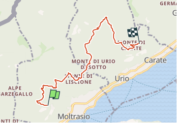
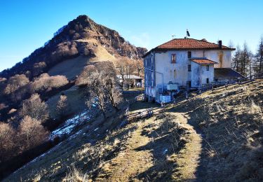
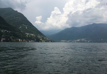
Tocht Te voet van 6,7 km beschikbaar op Lombardije, Como, Moltrasio. Deze tocht wordt voorgesteld door SityTrail - itinéraires balisés pédestres.
Beschrijving
Trail created by Comunità montana "Lario Intelvese".
a Monti di Madrona c'è un guidepost del sentiero 26 in direzione Scarone, Rovanna. Forse il sentiero 26 parte prima di Monti di Lenno? Sul sito della comunità montana Lario intelvese il sentiero 26 non è citato.
Plaatsbepaling
Opmerkingen
Wandeltochten in de omgeving
![Tocht Stappen Brunate - Boucle Brunate - Monte Piatto - Brunate - Photo](https://media.geolcdn.com/t/375/260/93a0945a-7986-4560-ba4c-8b9a27a09a51.jpg&format=jpg&maxdim=2)
![Stappen Stappen](https://static1.geolcdn.com/sitytour/trail-icons/101.png)
Stappen
![](/images/other/stat-length.png)
![](https://static1.geolcdn.com/siteimages/upload/files/16400158638029165_repeat_loop_refresh_sync_direction_icon.png)
![Tocht Te voet Como - (SI D10S) Como Monte Olimpino) - Piano del Tivano Rifugio Del Dosso - Photo](https://media.geolcdn.com/t/375/260/375b7a97-7915-45fb-b2a4-c0b06e6d2da7.jpeg&format=jpg&maxdim=2)
![Te voet Te voet](https://static1.geolcdn.com/sitytour/trail-icons/100.png)
Te voet
![](/images/other/stat-length.png)
![](https://static1.geolcdn.com/siteimages/upload/files/16400158638029165_repeat_loop_refresh_sync_direction_icon.png)
![Tocht Te voet Como - (SI D10N) Como (Monte Olimpino) - Rifugio Prabello - Photo](https://media.geolcdn.com/t/375/260/9fd7e13f-242d-48c1-a371-3d7e031e62ab.jpeg&format=jpg&maxdim=2)
![Te voet Te voet](https://static1.geolcdn.com/sitytour/trail-icons/100.png)
Te voet
![](/images/other/stat-length.png)
![](https://static1.geolcdn.com/siteimages/upload/files/16400158638029165_repeat_loop_refresh_sync_direction_icon.png)
![Tocht Te voet Carate Urio - Carate Urio - Rifugio Murelli - Photo](https://media.geolcdn.com/t/375/260/017c8256-cea1-432a-b38c-cca722956f17.jpeg&format=jpg&maxdim=2)
![Te voet Te voet](https://static1.geolcdn.com/sitytour/trail-icons/100.png)
Te voet
![](/images/other/stat-length.png)
![](https://static1.geolcdn.com/siteimages/upload/files/16400158638029165_repeat_loop_refresh_sync_direction_icon.png)
![Tocht Te voet Brunate - Lake Como Poetry Way - Photo](https://media.geolcdn.com/t/375/260/6178cb2f-ee45-4759-8b0a-ba0b934ee382.jpeg&format=jpg&maxdim=2)
![Te voet Te voet](https://static1.geolcdn.com/sitytour/trail-icons/100.png)
Te voet
![](/images/other/stat-length.png)
![](https://static1.geolcdn.com/siteimages/upload/files/16400158638029165_repeat_loop_refresh_sync_direction_icon.png)
![Tocht Te voet Cernobbio - Cernobbio-Monte Bisbino - Photo](https://media.geolcdn.com/t/375/260/0357d0b0-9faf-42dd-82d3-2178cbb6e129.jpeg&format=jpg&maxdim=2)
![Te voet Te voet](https://static1.geolcdn.com/sitytour/trail-icons/100.png)
Te voet
![](/images/other/stat-length.png)
![](https://static1.geolcdn.com/siteimages/upload/files/16400158638029165_repeat_loop_refresh_sync_direction_icon.png)
![Tocht Te voet Moltrasio - Moltrasio - Rifugio Bugone - Photo](https://media.geolcdn.com/t/375/260/ecbf7d97-3d82-4517-8f17-1157963299f2.jpeg&format=jpg&maxdim=2)
![Te voet Te voet](https://static1.geolcdn.com/sitytour/trail-icons/100.png)
Te voet
![](/images/other/stat-length.png)
![](https://static1.geolcdn.com/siteimages/upload/files/16400158638029165_repeat_loop_refresh_sync_direction_icon.png)
![Tocht Te voet Breggia - San Martino - Monte Bibino (I)? - fixme - Photo](https://media.geolcdn.com/t/375/260/0501b2fb-00d0-4920-b954-e954b1edbb93.jpeg&format=jpg&maxdim=2)
![Te voet Te voet](https://static1.geolcdn.com/sitytour/trail-icons/100.png)
Te voet
![](/images/other/stat-length.png)
![](https://static1.geolcdn.com/siteimages/upload/files/16400158638029165_repeat_loop_refresh_sync_direction_icon.png)
![Tocht Te voet Cernobbio - Monte Bisbino-Monte Generoso - Photo](https://media.geolcdn.com/t/375/260/b04c44a9-11d4-4fb4-aa9d-c031395551a7.jpeg&format=jpg&maxdim=2)
![Te voet Te voet](https://static1.geolcdn.com/sitytour/trail-icons/100.png)
Te voet
![](/images/other/stat-length.png)
![](https://static1.geolcdn.com/siteimages/upload/files/16400158638029165_repeat_loop_refresh_sync_direction_icon.png)