![](/images/other/stat-length.png)
![Tocht Te voet Caneva - Sentiero naturalistico O - Photo](https://media.geolcdn.com/t/1900/400/ext.pjpeg?maxdim=2&url=https%3A%2F%2Fstatic1.geolcdn.com%2Fsiteimages%2Fupload%2Ffiles%2F1545311037marcheuse_200dpi.jpg)
Sentiero naturalistico O
SityTrail - itinéraires balisés pédestres
Tous les sentiers balisés d’Europe GUIDE+
![Lengte](/images/other/stat-length.png)
Lengte
4,4 km
![Max. hoogte](https://static1.geolcdn.com/siteimages/upload/files/1508320355ic_sort_altitude_max_24dp.png)
Max. hoogte
1207 m
![Positief hoogteverschil](https://static1.geolcdn.com/siteimages/upload/files/1508320355ic_sort_den_pos_24dp.png)
Positief hoogteverschil
206 m
![Km-Effort](/images/other/stat-length.png)
Km-Effort
7,2 km
![Min. hoogte](https://static1.geolcdn.com/siteimages/upload/files/1508320355ic_sort_altitude_min_24dp.png)
Min. hoogte
999 m
![Negatief hoogteverschil](https://static1.geolcdn.com/siteimages/upload/files/1508320355ic_sort_den_neg_24dp.png)
Negatief hoogteverschil
203 m
![Boucle](https://static1.geolcdn.com/siteimages/upload/files/16400158638029165_repeat_loop_refresh_sync_direction_icon.png)
Boucle
Neen
Markering
Datum van aanmaak :
2022-02-14 22:48:44.571
Laatste wijziging :
2022-02-28 16:24:02.216
![Te voet](https://static1.geolcdn.com/sitytour/trail-icons/100.png)
1h37
Moeilijkheid : Gemakkelijk
![Scan deze QR-code om de tocht te openen in de SityTrail-applicatie](https://capi.geolives.com/qq0zvz2zws4bq2lad0pu/sitytour/trails/3112161/qr.png?size=200)
Gratisgps-wandelapplicatie
Over ons
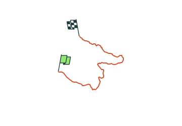
Tocht Te voet van 4,4 km beschikbaar op Friuli-Venezia Giulia, Onbekend, Caneva. Deze tocht wordt voorgesteld door SityTrail - itinéraires balisés pédestres.
Beschrijving
Change way color from red to orange if osmc:symbol will support it
Symbol: Black "O" on orange background
Plaatsbepaling
Land:
Italy
Regio :
Friuli-Venezia Giulia
Departement/Provincie :
Onbekend
Gemeente :
Caneva
Locatie:
Unknown
Vertrek:(Dec)
Vertrek:(UTM)
299571 ; 5102993 (33T) N.
Opmerkingen
Wandeltochten in de omgeving
![Tocht Te voet Caneva - IT-982 - Photo](https://media.geolcdn.com/t/375/260/1b4aa99f-7f34-46aa-883a-d5fb0c5bc225.jpeg&format=jpg&maxdim=2)
![Te voet Te voet](https://static1.geolcdn.com/sitytour/trail-icons/100.png)
IT-982
Te voet
Gemakkelijk
Caneva,
Friuli-Venezia Giulia,
Onbekend,
Italy
![](/images/other/stat-length.png)
4,1 km | 6,5 km-effort
1h 28min
![](https://static1.geolcdn.com/siteimages/upload/files/16400158638029165_repeat_loop_refresh_sync_direction_icon.png)
Neen
![Tocht Te voet Alpago - Sentiero naturalistico A - Photo](https://media.geolcdn.com/t/375/260/b1f7cbf9-58e8-4132-a051-ec1a8ce45262.jpeg&format=jpg&maxdim=2)
![Te voet Te voet](https://static1.geolcdn.com/sitytour/trail-icons/100.png)
Sentiero naturalistico A
Te voet
Gemakkelijk
Alpago,
Veneto,
Belluno,
Italy
![](/images/other/stat-length.png)
10,7 km | 14,9 km-effort
3h 23min
![](https://static1.geolcdn.com/siteimages/upload/files/16400158638029165_repeat_loop_refresh_sync_direction_icon.png)
Ja
![Tocht Te voet Fregona - Sentiero Naturalistico H3 - Photo](https://media.geolcdn.com/t/375/260/6c1010d2-7bd1-4e6e-9068-8040a3998555.jpeg&format=jpg&maxdim=2)
![Te voet Te voet](https://static1.geolcdn.com/sitytour/trail-icons/100.png)
Sentiero Naturalistico H3
Te voet
Gemakkelijk
Fregona,
Veneto,
Treviso,
Italy
![](/images/other/stat-length.png)
10,4 km | 14,4 km-effort
3h 16min
![](https://static1.geolcdn.com/siteimages/upload/files/16400158638029165_repeat_loop_refresh_sync_direction_icon.png)
Neen
![Tocht Te voet Fregona - Sentiero Naturalistico H - Photo](https://media.geolcdn.com/t/375/260/1b4aa99f-7f34-46aa-883a-d5fb0c5bc225.jpeg&format=jpg&maxdim=2)
![Te voet Te voet](https://static1.geolcdn.com/sitytour/trail-icons/100.png)
Sentiero Naturalistico H
Te voet
Gemakkelijk
Fregona,
Veneto,
Treviso,
Italy
![](/images/other/stat-length.png)
6,4 km | 7,9 km-effort
1h 48min
![](https://static1.geolcdn.com/siteimages/upload/files/16400158638029165_repeat_loop_refresh_sync_direction_icon.png)
Neen
![Tocht Te voet Tambre - Sentiero naturalistico B - Photo](https://media.geolcdn.com/t/375/260/b1f7cbf9-58e8-4132-a051-ec1a8ce45262.jpeg&format=jpg&maxdim=2)
![Te voet Te voet](https://static1.geolcdn.com/sitytour/trail-icons/100.png)
Sentiero naturalistico B
Te voet
Medium
Tambre,
Veneto,
Belluno,
Italy
![](/images/other/stat-length.png)
17 km | 23 km-effort
5h 16min
![](https://static1.geolcdn.com/siteimages/upload/files/16400158638029165_repeat_loop_refresh_sync_direction_icon.png)
Ja
![Tocht Te voet Alpago - Sentiero delle Piaie Longhe Milifret - Photo](https://media.geolcdn.com/t/375/260/80d49e0b-ef80-4deb-94cf-4e4177b25262.jpeg&format=jpg&maxdim=2)
![Te voet Te voet](https://static1.geolcdn.com/sitytour/trail-icons/100.png)
Sentiero delle Piaie Longhe Milifret
Te voet
Gemakkelijk
Alpago,
Veneto,
Belluno,
Italy
![](/images/other/stat-length.png)
5,3 km | 7,9 km-effort
1h 47min
![](https://static1.geolcdn.com/siteimages/upload/files/16400158638029165_repeat_loop_refresh_sync_direction_icon.png)
Neen
![Tocht Te voet Fregona - Sentiero Nino Lot - Photo](https://media.geolcdn.com/t/375/260/ext.jpg?maxdim=2&url=https%3A%2F%2Fstatic1.geolcdn.com%2Fsiteimages%2Fupload%2Ffiles%2F1545311037marcheuse_200dpi.jpg)
![Te voet Te voet](https://static1.geolcdn.com/sitytour/trail-icons/100.png)
Sentiero Nino Lot
Te voet
Gemakkelijk
Fregona,
Veneto,
Treviso,
Italy
![](/images/other/stat-length.png)
7,5 km | 17,1 km-effort
3h 53min
![](https://static1.geolcdn.com/siteimages/upload/files/16400158638029165_repeat_loop_refresh_sync_direction_icon.png)
Ja
![Tocht Te voet Fregona - IT-981A - Photo](https://media.geolcdn.com/t/375/260/ext.jpg?maxdim=2&url=https%3A%2F%2Fstatic1.geolcdn.com%2Fsiteimages%2Fupload%2Ffiles%2F1545311037marcheuse_200dpi.jpg)
![Te voet Te voet](https://static1.geolcdn.com/sitytour/trail-icons/100.png)
![Tocht Te voet Fregona - Sentiero del Bracconiere - Photo](https://media.geolcdn.com/t/375/260/ext.jpg?maxdim=2&url=https%3A%2F%2Fstatic1.geolcdn.com%2Fsiteimages%2Fupload%2Ffiles%2F1545311037marcheuse_200dpi.jpg)
![Te voet Te voet](https://static1.geolcdn.com/sitytour/trail-icons/100.png)
Sentiero del Bracconiere
Te voet
Gemakkelijk
Fregona,
Veneto,
Treviso,
Italy
![](/images/other/stat-length.png)
3,7 km | 7,2 km-effort
1h 37min
![](https://static1.geolcdn.com/siteimages/upload/files/16400158638029165_repeat_loop_refresh_sync_direction_icon.png)
Neen