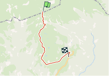
![](/images/other/stat-length.png)
![Tocht Te voet Vedeseta - Quindicina - Rifugio Gherardi - Bocchetta Regadur - Photo](https://media.geolcdn.com/t/1900/400/c7c6d5f4-39a1-45cf-b184-ba5452088c1a.jpeg&format=pjpeg&maxdim=2)
Quindicina - Rifugio Gherardi - Bocchetta Regadur
SityTrail - itinéraires balisés pédestres
Tous les sentiers balisés d’Europe GUIDE+
![Lengte](/images/other/stat-length.png)
![Max. hoogte](https://static1.geolcdn.com/siteimages/upload/files/1508320355ic_sort_altitude_max_24dp.png)
![Positief hoogteverschil](https://static1.geolcdn.com/siteimages/upload/files/1508320355ic_sort_den_pos_24dp.png)
![Km-Effort](/images/other/stat-length.png)
![Min. hoogte](https://static1.geolcdn.com/siteimages/upload/files/1508320355ic_sort_altitude_min_24dp.png)
![Negatief hoogteverschil](https://static1.geolcdn.com/siteimages/upload/files/1508320355ic_sort_den_neg_24dp.png)
![Boucle](https://static1.geolcdn.com/siteimages/upload/files/16400158638029165_repeat_loop_refresh_sync_direction_icon.png)
![Te voet](https://static1.geolcdn.com/sitytour/trail-icons/100.png)
1h26
Moeilijkheid : Gemakkelijk
![Scan deze QR-code om de tocht te openen in de SityTrail-applicatie](https://capi.geolives.com/qq0zvz2zws4bq2lad0pu/sitytour/trails/3112082/qr.png?size=200)
Gratisgps-wandelapplicatie
Over ons
Tocht Te voet van 4,4 km beschikbaar op Lombardije, Bergamo, Vedeseta. Deze tocht wordt voorgesteld door SityTrail - itinéraires balisés pédestres.
Beschrijving
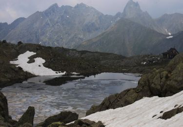
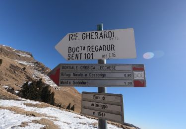
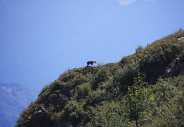
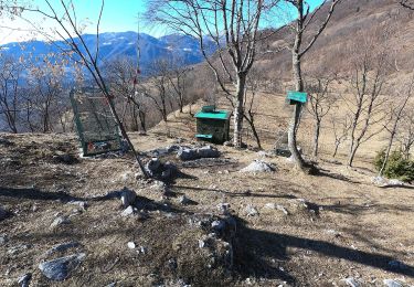
Poco prima della località Quindicina (Pizzino) dalla strada carrale si imbocca il sentiero che sale sulla sinistra (cartello - quota 1282 m). Dopo un breve tratto nel bosco si piega a destra, raggiungendo un alpeggio con bella vista sul Resegone e poi, con percorso facile, si guadagna l'altipiano dove è posto il rifugio Gherardi (1651 m - h 1.10). Proseguendo in direzione nord
Website: http://geoportale.caibergamo.it/sentiero/120
Plaatsbepaling
Opmerkingen
Wandeltochten in de omgeving
![Tocht Te voet Moggio - Traversata Artavaggio - Bobbio - Photo](https://media.geolcdn.com/t/375/260/09d510e2-f6ad-4996-b599-3605221ca888.jpeg&format=jpg&maxdim=2)
![Te voet Te voet](https://static1.geolcdn.com/sitytour/trail-icons/100.png)
Te voet
![](/images/other/stat-length.png)
![](https://static1.geolcdn.com/siteimages/upload/files/16400158638029165_repeat_loop_refresh_sync_direction_icon.png)
![Tocht Te voet Barzio - Sentiero delle Orobie Occidentali - Tappa 2 - Photo](https://media.geolcdn.com/t/375/260/62425f4a-83c8-4010-b4fe-ebd01c1857b6.jpeg&format=jpg&maxdim=2)
![Te voet Te voet](https://static1.geolcdn.com/sitytour/trail-icons/100.png)
Te voet
![](/images/other/stat-length.png)
![](https://static1.geolcdn.com/siteimages/upload/files/16400158638029165_repeat_loop_refresh_sync_direction_icon.png)
![Tocht Te voet Barzio - Sentiero degli stradini - Photo](https://media.geolcdn.com/t/375/260/5a6a4880-c1df-4055-a06f-5e2791a54330.jpeg&format=jpg&maxdim=2)
![Te voet Te voet](https://static1.geolcdn.com/sitytour/trail-icons/100.png)
Te voet
![](/images/other/stat-length.png)
![](https://static1.geolcdn.com/siteimages/upload/files/16400158638029165_repeat_loop_refresh_sync_direction_icon.png)
![Tocht Te voet Moggio - Sentiero Antichi Cippi Confinari - Photo](https://media.geolcdn.com/t/375/260/26d4af1d-bf34-4b3e-ba88-069511a4c80e.jpeg&format=jpg&maxdim=2)
![Te voet Te voet](https://static1.geolcdn.com/sitytour/trail-icons/100.png)
Te voet
![](/images/other/stat-length.png)
![](https://static1.geolcdn.com/siteimages/upload/files/16400158638029165_repeat_loop_refresh_sync_direction_icon.png)
![Tocht Te voet Valtorta - Piani di Valtorta – incrocio sentiero 101 (Rif. Cazzaniga) - Photo](https://media.geolcdn.com/t/375/260/80c66bfd-747f-47a1-9d7e-e3e28c8b9faf.jpeg&format=jpg&maxdim=2)
![Te voet Te voet](https://static1.geolcdn.com/sitytour/trail-icons/100.png)
Te voet
![](/images/other/stat-length.png)
![](https://static1.geolcdn.com/siteimages/upload/files/16400158638029165_repeat_loop_refresh_sync_direction_icon.png)
![Tocht Te voet Valtorta - Valtorta (Piani Bassi) - Rifugio Cazzaniga-Merlini - Photo](https://media.geolcdn.com/t/375/260/d173a5fe-87eb-403f-9d91-cc95861c0a64.jpeg&format=jpg&maxdim=2)
![Te voet Te voet](https://static1.geolcdn.com/sitytour/trail-icons/100.png)
Te voet
![](/images/other/stat-length.png)
![](https://static1.geolcdn.com/siteimages/upload/files/16400158638029165_repeat_loop_refresh_sync_direction_icon.png)
![Tocht Te voet Barzio - Rifugio Lecco - Rifugio Grassi - Photo](https://media.geolcdn.com/t/375/260/46c52b94-a4f6-46da-a2cc-e9178b760723.jpeg&format=jpg&maxdim=2)
![Te voet Te voet](https://static1.geolcdn.com/sitytour/trail-icons/100.png)
Te voet
![](/images/other/stat-length.png)
![](https://static1.geolcdn.com/siteimages/upload/files/16400158638029165_repeat_loop_refresh_sync_direction_icon.png)
![Tocht Te voet Taleggio - Capo Foppa - Passo Baciamorti - Photo](https://media.geolcdn.com/t/375/260/a53077d3-9b83-4c0a-ac9c-543d674abcc9.jpeg&format=jpg&maxdim=2)
![Te voet Te voet](https://static1.geolcdn.com/sitytour/trail-icons/100.png)
Te voet
![](/images/other/stat-length.png)
![](https://static1.geolcdn.com/siteimages/upload/files/16400158638029165_repeat_loop_refresh_sync_direction_icon.png)
![Tocht Te voet Valtorta - Sentiero 104: Valtorta (Costa) - Rifugio Grassi - Photo](https://media.geolcdn.com/t/375/260/46c52b94-a4f6-46da-a2cc-e9178b760723.jpeg&format=jpg&maxdim=2)
![Te voet Te voet](https://static1.geolcdn.com/sitytour/trail-icons/100.png)
Te voet
![](/images/other/stat-length.png)
![](https://static1.geolcdn.com/siteimages/upload/files/16400158638029165_repeat_loop_refresh_sync_direction_icon.png)