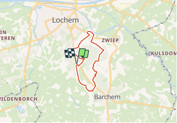
![](/images/other/stat-length.png)
![Tocht Te voet Lochem - Lochemse Berg Route - Photo](https://media.geolcdn.com/t/1900/400/0b3bf5ef-5885-40ac-820f-254b98fec905.jpeg&format=pjpeg&maxdim=2)
Lochemse Berg Route
SityTrail - itinéraires balisés pédestres
Tous les sentiers balisés d’Europe GUIDE+
![Lengte](/images/other/stat-length.png)
![Max. hoogte](https://static1.geolcdn.com/siteimages/upload/files/1508320355ic_sort_altitude_max_24dp.png)
![Positief hoogteverschil](https://static1.geolcdn.com/siteimages/upload/files/1508320355ic_sort_den_pos_24dp.png)
![Km-Effort](/images/other/stat-length.png)
![Min. hoogte](https://static1.geolcdn.com/siteimages/upload/files/1508320355ic_sort_altitude_min_24dp.png)
![Negatief hoogteverschil](https://static1.geolcdn.com/siteimages/upload/files/1508320355ic_sort_den_neg_24dp.png)
![Boucle](https://static1.geolcdn.com/siteimages/upload/files/16400158638029165_repeat_loop_refresh_sync_direction_icon.png)
![Te voet](https://static1.geolcdn.com/sitytour/trail-icons/100.png)
2h18
Moeilijkheid : Gemakkelijk
![Scan deze QR-code om de tocht te openen in de SityTrail-applicatie](https://capi.geolives.com/qq0zvz2zws4bq2lad0pu/sitytour/trails/3110875/qr.png?size=200)
Gratisgps-wandelapplicatie
Over ons
Tocht Te voet van 8,5 km beschikbaar op Gelderland, Onbekend, Lochem. Deze tocht wordt voorgesteld door SityTrail - itinéraires balisés pédestres.
Beschrijving
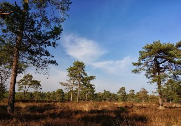
Tijdens deze wandelroute wandel je over de Lochemse Berg. Een gevarieerd landschap met prachtige bomen en vergezichten. Bekijk hier de route!
Website: https://achterhoek.nl/Lochemse-Bergroute
Plaatsbepaling
Opmerkingen
Wandeltochten in de omgeving
![Tocht Te voet Lochem - Rondje Barchem - Photo](https://media.geolcdn.com/t/375/260/7fc336cf-e104-491e-940c-7899e0be83de.jpeg&format=jpg&maxdim=2)
![Te voet Te voet](https://static1.geolcdn.com/sitytour/trail-icons/100.png)
Te voet
![](/images/other/stat-length.png)
![](https://static1.geolcdn.com/siteimages/upload/files/16400158638029165_repeat_loop_refresh_sync_direction_icon.png)
![Tocht Te voet Lochem - Barchems Wandel Ommetje - Photo](https://media.geolcdn.com/t/375/260/7fc336cf-e104-491e-940c-7899e0be83de.jpeg&format=jpg&maxdim=2)
![Te voet Te voet](https://static1.geolcdn.com/sitytour/trail-icons/100.png)
Te voet
![](/images/other/stat-length.png)
![](https://static1.geolcdn.com/siteimages/upload/files/16400158638029165_repeat_loop_refresh_sync_direction_icon.png)
![Tocht Te voet Lochem - De Boschheurne Route - Photo](https://media.geolcdn.com/t/375/260/7fc336cf-e104-491e-940c-7899e0be83de.jpeg&format=jpg&maxdim=2)
![Te voet Te voet](https://static1.geolcdn.com/sitytour/trail-icons/100.png)
Te voet
![](/images/other/stat-length.png)
![](https://static1.geolcdn.com/siteimages/upload/files/16400158638029165_repeat_loop_refresh_sync_direction_icon.png)
![Tocht Te voet Bronckhorst - De Wildenborch Route - Photo](https://media.geolcdn.com/t/375/260/03237455-549e-486d-9ec0-9a1319ae6ede.jpeg&format=jpg&maxdim=2)
![Te voet Te voet](https://static1.geolcdn.com/sitytour/trail-icons/100.png)
Te voet
![](/images/other/stat-length.png)
![](https://static1.geolcdn.com/siteimages/upload/files/16400158638029165_repeat_loop_refresh_sync_direction_icon.png)
![Tocht Te voet Lochem - Poort van Lochem - Photo](https://media.geolcdn.com/t/375/260/845ff6b2-8648-434a-929d-70c911bb0eaf.jpeg&format=jpg&maxdim=2)
![Te voet Te voet](https://static1.geolcdn.com/sitytour/trail-icons/100.png)
Te voet
![](/images/other/stat-length.png)
![](https://static1.geolcdn.com/siteimages/upload/files/16400158638029165_repeat_loop_refresh_sync_direction_icon.png)
![Tocht Te voet Lochem - Hof van Gelre route - Photo](https://media.geolcdn.com/t/375/260/76046cee-7211-4169-ab7f-ed32bbd399f8.jpeg&format=jpg&maxdim=2)
![Te voet Te voet](https://static1.geolcdn.com/sitytour/trail-icons/100.png)
Te voet
![](/images/other/stat-length.png)
![](https://static1.geolcdn.com/siteimages/upload/files/16400158638029165_repeat_loop_refresh_sync_direction_icon.png)
![Tocht Te voet Lochem - Grote Veldroute - Photo](https://media.geolcdn.com/t/375/260/c3f659ef-52a0-470b-ae39-f1723f5a44e6.jpeg&format=jpg&maxdim=2)
![Te voet Te voet](https://static1.geolcdn.com/sitytour/trail-icons/100.png)
Te voet
![](/images/other/stat-length.png)
![](https://static1.geolcdn.com/siteimages/upload/files/16400158638029165_repeat_loop_refresh_sync_direction_icon.png)
![Tocht Te voet Bronckhorst - Cuypers op de Kranenburg route - Photo](https://media.geolcdn.com/t/375/260/ecd8b40b-1fcb-405a-a889-8327ccafdca2.jpeg&format=jpg&maxdim=2)
![Te voet Te voet](https://static1.geolcdn.com/sitytour/trail-icons/100.png)
Te voet
![](/images/other/stat-length.png)
![](https://static1.geolcdn.com/siteimages/upload/files/16400158638029165_repeat_loop_refresh_sync_direction_icon.png)
![Tocht Te voet Lochem - Kale Berg Route - Photo](https://media.geolcdn.com/t/375/260/7fc336cf-e104-491e-940c-7899e0be83de.jpeg&format=jpg&maxdim=2)
![Te voet Te voet](https://static1.geolcdn.com/sitytour/trail-icons/100.png)
Te voet
![](/images/other/stat-length.png)
![](https://static1.geolcdn.com/siteimages/upload/files/16400158638029165_repeat_loop_refresh_sync_direction_icon.png)