![](/images/other/stat-length.png)
![Tocht Te voet Llardecans - Llardecans-Les Costes - Photo](https://media.geolcdn.com/t/1900/400/09794eb4-81c1-4c28-b2bf-fcc360b449df.jpeg&format=pjpeg&maxdim=2)
Llardecans-Les Costes
SityTrail - itinéraires balisés pédestres
Tous les sentiers balisés d’Europe GUIDE+
![Lengte](/images/other/stat-length.png)
Lengte
24 km
![Max. hoogte](https://static1.geolcdn.com/siteimages/upload/files/1508320355ic_sort_altitude_max_24dp.png)
Max. hoogte
452 m
![Positief hoogteverschil](https://static1.geolcdn.com/siteimages/upload/files/1508320355ic_sort_den_pos_24dp.png)
Positief hoogteverschil
524 m
![Km-Effort](/images/other/stat-length.png)
Km-Effort
31 km
![Min. hoogte](https://static1.geolcdn.com/siteimages/upload/files/1508320355ic_sort_altitude_min_24dp.png)
Min. hoogte
221 m
![Negatief hoogteverschil](https://static1.geolcdn.com/siteimages/upload/files/1508320355ic_sort_den_neg_24dp.png)
Negatief hoogteverschil
524 m
![Boucle](https://static1.geolcdn.com/siteimages/upload/files/16400158638029165_repeat_loop_refresh_sync_direction_icon.png)
Boucle
Ja
Markering
Datum van aanmaak :
2022-02-14 15:46:53.962
Laatste wijziging :
2022-02-14 15:46:53.962
![Te voet](https://static1.geolcdn.com/sitytour/trail-icons/100.png)
7h03
Moeilijkheid : Moeilijk
![Scan deze QR-code om de tocht te openen in de SityTrail-applicatie](https://capi.geolives.com/qq0zvz2zws4bq2lad0pu/sitytour/trails/3110631/qr.png?size=200)
Gratisgps-wandelapplicatie
Over ons
Tocht Te voet van 24 km beschikbaar op Catalonië, Lerida, Llardecans. Deze tocht wordt voorgesteld door SityTrail - itinéraires balisés pédestres.
Beschrijving
Website: http://segriasec.org/turisme/ruta-senderisme-btt-al-segria-sec/
Plaatsbepaling
Land:
Spain
Regio :
Catalonië
Departement/Provincie :
Lerida
Gemeente :
Llardecans
Locatie:
Unknown
Vertrek:(Dec)
Vertrek:(UTM)
295146 ; 4583165 (31T) N.
Opmerkingen
Wandeltochten in de omgeving
![Tocht Te voet la Bisbal de Falset - La Bisbal de Falset - Photo](https://media.geolcdn.com/t/375/260/a5c3a0bc-5422-4ea8-88d7-b655ceab7587.jpeg&format=jpg&maxdim=2)
![Te voet Te voet](https://static1.geolcdn.com/sitytour/trail-icons/100.png)
La Bisbal de Falset
Te voet
Gemakkelijk
la Bisbal de Falset,
Catalonië,
Tarragona,
Spain
![](/images/other/stat-length.png)
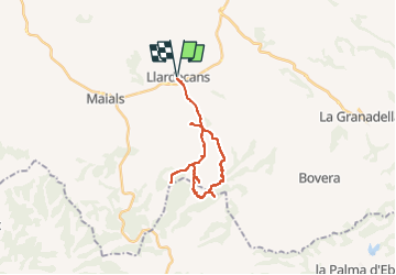
10,3 km | 15,5 km-effort
3h 30min
![](https://static1.geolcdn.com/siteimages/upload/files/16400158638029165_repeat_loop_refresh_sync_direction_icon.png)
Ja
![Tocht Te voet la Vilella Baixa - La Vilella Baixa - Photo](https://media.geolcdn.com/t/375/260/6b4bec61-8192-42c8-abac-f82c1856efa1.jpeg&format=jpg&maxdim=2)
![Te voet Te voet](https://static1.geolcdn.com/sitytour/trail-icons/100.png)
La Vilella Baixa
Te voet
Gemakkelijk
la Vilella Baixa,
Catalonië,
Tarragona,
Spain
![](/images/other/stat-length.png)
8 km | 13,3 km-effort
3h 0min
![](https://static1.geolcdn.com/siteimages/upload/files/16400158638029165_repeat_loop_refresh_sync_direction_icon.png)
Ja
![Tocht Te voet la Bisbal de Falset - Oliveres damunt la roca - Photo](https://media.geolcdn.com/t/375/260/a5c3a0bc-5422-4ea8-88d7-b655ceab7587.jpeg&format=jpg&maxdim=2)
![Te voet Te voet](https://static1.geolcdn.com/sitytour/trail-icons/100.png)
Oliveres damunt la roca
Te voet
Gemakkelijk
la Bisbal de Falset,
Catalonië,
Tarragona,
Spain
![](/images/other/stat-length.png)
3,1 km | 4,8 km-effort
1h 4min
![](https://static1.geolcdn.com/siteimages/upload/files/16400158638029165_repeat_loop_refresh_sync_direction_icon.png)
Ja
![Tocht Te voet la Vilella Baixa - Vilella Baixa-La Figuera-Cabacés. El vi i l'oli del Bisbe - Photo](https://media.geolcdn.com/t/375/260/d45b0219-776c-49ed-8698-df390ba7aba2.jpeg&format=jpg&maxdim=2)
![Te voet Te voet](https://static1.geolcdn.com/sitytour/trail-icons/100.png)
Vilella Baixa-La Figuera-Cabacés. El vi i l'oli del Bisbe
Te voet
Medium
la Vilella Baixa,
Catalonië,
Tarragona,
Spain
![](/images/other/stat-length.png)
15,6 km | 26 km-effort
5h 49min
![](https://static1.geolcdn.com/siteimages/upload/files/16400158638029165_repeat_loop_refresh_sync_direction_icon.png)
Ja
![Tocht Te voet la Vilella Baixa - De la Vilella Baixa a la Figuera - Photo](https://media.geolcdn.com/t/375/260/6b4bec61-8192-42c8-abac-f82c1856efa1.jpeg&format=jpg&maxdim=2)
![Te voet Te voet](https://static1.geolcdn.com/sitytour/trail-icons/100.png)
De la Vilella Baixa a la Figuera
Te voet
Gemakkelijk
la Vilella Baixa,
Catalonië,
Tarragona,
Spain
![](/images/other/stat-length.png)
3,2 km | 6,8 km-effort
1h 32min
![](https://static1.geolcdn.com/siteimages/upload/files/16400158638029165_repeat_loop_refresh_sync_direction_icon.png)
Neen
![Tocht Te voet la Granja d'Escarp - De l'Aiguabarreig a Montmaneu - Photo](https://media.geolcdn.com/t/375/260/77c465ae-d514-4707-8ef5-c4b07e73de21.jpeg&format=jpg&maxdim=2)
![Te voet Te voet](https://static1.geolcdn.com/sitytour/trail-icons/100.png)
De l'Aiguabarreig a Montmaneu
Te voet
Medium
la Granja d'Escarp,
Catalonië,
Lerida,
Spain
![](/images/other/stat-length.png)
23 km | 30 km-effort
6h 46min
![](https://static1.geolcdn.com/siteimages/upload/files/16400158638029165_repeat_loop_refresh_sync_direction_icon.png)
Ja
![Tocht Te voet la Figuera - La Figuera - Photo](https://media.geolcdn.com/t/375/260/45075f1c-30a7-43d9-b0f9-10f1a60b0fb8.jpeg&format=jpg&maxdim=2)
![Te voet Te voet](https://static1.geolcdn.com/sitytour/trail-icons/100.png)
La Figuera
Te voet
Gemakkelijk
la Figuera,
Catalonië,
Tarragona,
Spain
![](/images/other/stat-length.png)
4,3 km | 6,8 km-effort
1h 32min
![](https://static1.geolcdn.com/siteimages/upload/files/16400158638029165_repeat_loop_refresh_sync_direction_icon.png)
Ja
![Tocht Te voet Cabacés - Cabacés. Ruta de les aigües - Photo](https://media.geolcdn.com/t/375/260/438a0b94-ae52-4d72-8cad-b180ef1a1b98.jpeg&format=jpg&maxdim=2)
![Te voet Te voet](https://static1.geolcdn.com/sitytour/trail-icons/100.png)
Cabacés. Ruta de les aigües
Te voet
Gemakkelijk
Cabacés,
Catalonië,
Tarragona,
Spain
![](/images/other/stat-length.png)
4,8 km | 8,2 km-effort
1h 52min
![](https://static1.geolcdn.com/siteimages/upload/files/16400158638029165_repeat_loop_refresh_sync_direction_icon.png)
Ja
![Tocht Te voet Torres de Segre - Camí Natural del Riu Segre i Embassament d'Utxesa - Photo](https://media.geolcdn.com/t/375/260/2be6a65c-7113-443a-b2b2-7e8ad921d1aa.jpeg&format=jpg&maxdim=2)
![Te voet Te voet](https://static1.geolcdn.com/sitytour/trail-icons/100.png)
Camí Natural del Riu Segre i Embassament d'Utxesa
Te voet
Gemakkelijk
Torres de Segre,
Catalonië,
Lerida,
Spain
![](/images/other/stat-length.png)
16,1 km | 17,9 km-effort
4h 4min
![](https://static1.geolcdn.com/siteimages/upload/files/16400158638029165_repeat_loop_refresh_sync_direction_icon.png)
Neen