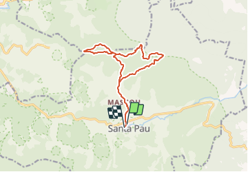
![](/images/other/stat-length.png)
![Tocht Te voet Santa Pau - Antics camins de monjos - Photo](https://media.geolcdn.com/t/1900/400/3bb77803-26a3-4043-9ee0-04b33520a521.jpeg&format=pjpeg&maxdim=2)
Antics camins de monjos
SityTrail - itinéraires balisés pédestres
Tous les sentiers balisés d’Europe GUIDE+
![Lengte](/images/other/stat-length.png)
![Max. hoogte](https://static1.geolcdn.com/siteimages/upload/files/1508320355ic_sort_altitude_max_24dp.png)
![Positief hoogteverschil](https://static1.geolcdn.com/siteimages/upload/files/1508320355ic_sort_den_pos_24dp.png)
![Km-Effort](/images/other/stat-length.png)
![Min. hoogte](https://static1.geolcdn.com/siteimages/upload/files/1508320355ic_sort_altitude_min_24dp.png)
![Negatief hoogteverschil](https://static1.geolcdn.com/siteimages/upload/files/1508320355ic_sort_den_neg_24dp.png)
![Boucle](https://static1.geolcdn.com/siteimages/upload/files/16400158638029165_repeat_loop_refresh_sync_direction_icon.png)
![Te voet](https://static1.geolcdn.com/sitytour/trail-icons/100.png)
5h10
Moeilijkheid : Medium
![Scan deze QR-code om de tocht te openen in de SityTrail-applicatie](https://capi.geolives.com/qq0zvz2zws4bq2lad0pu/sitytour/trails/3110512/qr.png?size=200)
Gratisgps-wandelapplicatie
Over ons
Tocht Te voet van 14,4 km beschikbaar op Catalonië, Gerona, Santa Pau. Deze tocht wordt voorgesteld door SityTrail - itinéraires balisés pédestres.
Beschrijving
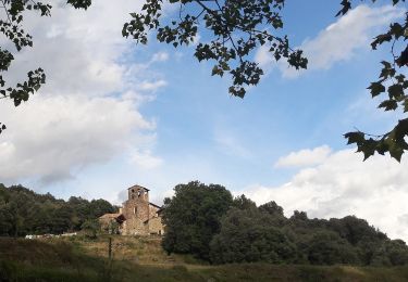
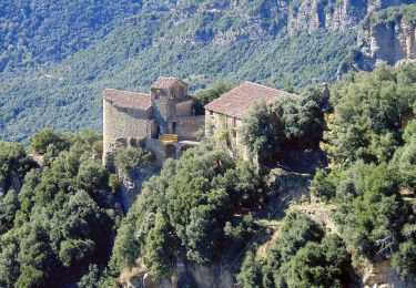
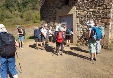
Al pujar a Sant Julià del Mont la vall de santa Pau s’obre als nostres peus i podem comprovar com les laves dels volcans Santa Margarida i Roca Negra van omplir tota la vall, formant una plana ample i fèrtil.
Website: https://www.itinerannia.net/ca/itineraris/per-antics-camins-de-monjos-ruta-2-santa-pau/
Plaatsbepaling
Opmerkingen
Wandeltochten in de omgeving
![Tocht Te voet Santa Pau - ES-4 - Photo](https://media.geolcdn.com/t/375/260/105b404d-8690-4297-9a59-5aca6e389be6.jpeg&format=jpg&maxdim=2)
![Te voet Te voet](https://static1.geolcdn.com/sitytour/trail-icons/100.png)
![Tocht Te voet Santa Pau - Santa Pau, ruta dels gorgs - Photo](https://media.geolcdn.com/t/375/260/cbbca8b8-4dab-41ad-b762-bcdb981c9904.jpeg&format=jpg&maxdim=2)
![Te voet Te voet](https://static1.geolcdn.com/sitytour/trail-icons/100.png)
Te voet
![](/images/other/stat-length.png)
![](https://static1.geolcdn.com/siteimages/upload/files/16400158638029165_repeat_loop_refresh_sync_direction_icon.png)
![Tocht Te voet Santa Pau - Els dos castells - Photo](https://media.geolcdn.com/t/375/260/2af90b94-9152-4cec-9ae1-106ec96aeddf.jpeg&format=jpg&maxdim=2)
![Te voet Te voet](https://static1.geolcdn.com/sitytour/trail-icons/100.png)
Te voet
![](/images/other/stat-length.png)
![](https://static1.geolcdn.com/siteimages/upload/files/16400158638029165_repeat_loop_refresh_sync_direction_icon.png)
![Tocht Te voet Santa Pau - Ruta per les Terres dels Barons de Santa Pau - Photo](https://media.geolcdn.com/t/375/260/8fdf282d-7b3c-468d-97b6-9e63fcc63455.jpeg&format=jpg&maxdim=2)
![Te voet Te voet](https://static1.geolcdn.com/sitytour/trail-icons/100.png)
Te voet
![](/images/other/stat-length.png)
![](https://static1.geolcdn.com/siteimages/upload/files/16400158638029165_repeat_loop_refresh_sync_direction_icon.png)
![Tocht Stappen Santa Pau - la Garrotxa : volcan Santa Margarida et volcan de Croscat - Photo](https://media.geolcdn.com/t/375/260/441fa517-aa41-4f1d-a8d0-4700a9d6df64.jpg&format=jpg&maxdim=2)
![Stappen Stappen](https://static1.geolcdn.com/sitytour/trail-icons/101.png)
Stappen
![](/images/other/stat-length.png)
![](https://static1.geolcdn.com/siteimages/upload/files/16400158638029165_repeat_loop_refresh_sync_direction_icon.png)
![Tocht Stappen Santa Pau - La Garrotxa: Volcans de Santa Margarida et de Croscat - Photo](https://media.geolcdn.com/t/375/260/6258e670-7bf5-4f8c-ba43-9f623ad06454.jpeg&format=jpg&maxdim=2)
![Stappen Stappen](https://static1.geolcdn.com/sitytour/trail-icons/101.png)
Stappen
![](/images/other/stat-length.png)
![](https://static1.geolcdn.com/siteimages/upload/files/16400158638029165_repeat_loop_refresh_sync_direction_icon.png)
![Tocht Stappen Olot - Les volcans de la GARROTXES (Espagne) (30/05/2019) - Photo](https://media.geolcdn.com/t/375/260/f008fea3-bb90-4f55-a39a-f318fdcd5fa2.jpg&format=jpg&maxdim=2)
![Stappen Stappen](https://static1.geolcdn.com/sitytour/trail-icons/101.png)
Stappen
![](/images/other/stat-length.png)
![](https://static1.geolcdn.com/siteimages/upload/files/16400158638029165_repeat_loop_refresh_sync_direction_icon.png)
![Tocht Stappen Santa Pau - Garrotxa J2fait - Photo](https://media.geolcdn.com/t/375/260/921844d9-3c73-4184-86a1-d49a6e3bd4ad.jpg&format=jpg&maxdim=2)
![Stappen Stappen](https://static1.geolcdn.com/sitytour/trail-icons/101.png)
Stappen
![](/images/other/stat-length.png)
![](https://static1.geolcdn.com/siteimages/upload/files/16400158638029165_repeat_loop_refresh_sync_direction_icon.png)
![Tocht Stappen Santa Pau - Essai Sant Pau Garrotxa - Photo](https://media.geolcdn.com/t/375/260/e957c9f7-cdcd-415c-b335-f80781aa1994.jpg&format=jpg&maxdim=2)
![Stappen Stappen](https://static1.geolcdn.com/sitytour/trail-icons/101.png)
Stappen
![](/images/other/stat-length.png)
![](https://static1.geolcdn.com/siteimages/upload/files/16400158638029165_repeat_loop_refresh_sync_direction_icon.png)