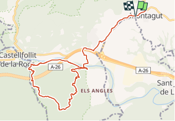
![](/images/other/stat-length.png)
![Tocht Te voet Montagut i Oix - Montagut-Ermita de la Devesa-Baumes de la Caxurma - Photo](https://media.geolcdn.com/t/1900/400/1fea31c6-a1f7-4cd5-9fb2-91cc07d26e9e.jpeg&format=pjpeg&maxdim=2)
Montagut-Ermita de la Devesa-Baumes de la Caxurma
SityTrail - itinéraires balisés pédestres
Tous les sentiers balisés d’Europe GUIDE+
![Lengte](/images/other/stat-length.png)
![Max. hoogte](https://static1.geolcdn.com/siteimages/upload/files/1508320355ic_sort_altitude_max_24dp.png)
![Positief hoogteverschil](https://static1.geolcdn.com/siteimages/upload/files/1508320355ic_sort_den_pos_24dp.png)
![Km-Effort](/images/other/stat-length.png)
![Min. hoogte](https://static1.geolcdn.com/siteimages/upload/files/1508320355ic_sort_altitude_min_24dp.png)
![Negatief hoogteverschil](https://static1.geolcdn.com/siteimages/upload/files/1508320355ic_sort_den_neg_24dp.png)
![Boucle](https://static1.geolcdn.com/siteimages/upload/files/16400158638029165_repeat_loop_refresh_sync_direction_icon.png)
![Te voet](https://static1.geolcdn.com/sitytour/trail-icons/100.png)
4h22
Moeilijkheid : Gemakkelijk
![Scan deze QR-code om de tocht te openen in de SityTrail-applicatie](https://capi.geolives.com/qq0zvz2zws4bq2lad0pu/sitytour/trails/3110434/qr.png?size=200)
Gratisgps-wandelapplicatie
Over ons
Tocht Te voet van 13,1 km beschikbaar op Catalonië, Gerona, Montagut i Oix. Deze tocht wordt voorgesteld door SityTrail - itinéraires balisés pédestres.
Beschrijving
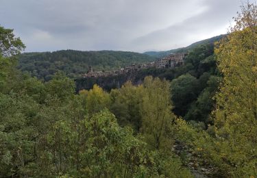
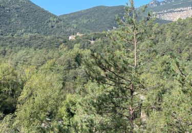
Les Baumes de Caxurma són un conjunt de cavitats ubicades en els materials sedimentaris del sud de la cinglera basàltica de Castellfollit de la Roca, la cavitat més important té uns 400 metres de recorregut
Website: https://www.itinerannia.net/ca/itineraris/ruta-la-devesa-i-les-baumes-de-caxurma-ruta-1-montagut-i-oix/
Plaatsbepaling
Opmerkingen
Wandeltochten in de omgeving
![Tocht Te voet Tortellà - Els Comuns. Tortellà - Photo](https://media.geolcdn.com/t/375/260/77e3f571-f015-4fa3-9216-7388ce4a3e2a.jpeg&format=jpg&maxdim=2)
![Te voet Te voet](https://static1.geolcdn.com/sitytour/trail-icons/100.png)
Te voet
![](/images/other/stat-length.png)
![](https://static1.geolcdn.com/siteimages/upload/files/16400158638029165_repeat_loop_refresh_sync_direction_icon.png)
![Tocht Te voet Sales de Llierca - L'Alta Garrotxa de Vayreda - Photo](https://media.geolcdn.com/t/375/260/f52cff0d-f5c0-40bd-a266-b7fc01d75938.jpeg&format=jpg&maxdim=2)
![Te voet Te voet](https://static1.geolcdn.com/sitytour/trail-icons/100.png)
Te voet
![](/images/other/stat-length.png)
![](https://static1.geolcdn.com/siteimages/upload/files/16400158638029165_repeat_loop_refresh_sync_direction_icon.png)
![Tocht Stappen Montagut i Oix - CASTELLFOLLIT DE LA ROCA - Photo](https://media.geolcdn.com/t/375/260/ea60c58d-17d7-42f2-85ca-a29d0fa72faa.jpg&format=jpg&maxdim=2)
![Stappen Stappen](https://static1.geolcdn.com/sitytour/trail-icons/101.png)
Stappen
![](/images/other/stat-length.png)
![](https://static1.geolcdn.com/siteimages/upload/files/16400158638029165_repeat_loop_refresh_sync_direction_icon.png)
![Tocht Stappen Sales de Llierca - Sadernes Sant Aniol - Photo](https://media.geolcdn.com/t/375/260/db335b61-6ee0-4b21-a956-4377b2f8d2ee.jpg&format=jpg&maxdim=2)
![Stappen Stappen](https://static1.geolcdn.com/sitytour/trail-icons/101.png)
Stappen
![](/images/other/stat-length.png)
![](https://static1.geolcdn.com/siteimages/upload/files/16400158638029165_repeat_loop_refresh_sync_direction_icon.png)
![Tocht Stappen Tortellà - Llercat Saderne - Photo](https://media.geolcdn.com/t/375/260/6cdc333b-3a4b-4d4a-a55a-45043c793942.jpg&format=jpg&maxdim=2)
![Stappen Stappen](https://static1.geolcdn.com/sitytour/trail-icons/101.png)
Stappen
![](/images/other/stat-length.png)
![](https://static1.geolcdn.com/siteimages/upload/files/16400158638029165_repeat_loop_refresh_sync_direction_icon.png)
![Tocht Stappen Sales de Llierca - Gorges de St Aniol Sadernes - Photo](https://media.geolcdn.com/t/375/260/ext.jpg?maxdim=2&url=https%3A%2F%2Fservices.sitytrail.com%2FGeolivesWS%2FDownloadMedia.ashx%3FTrailID%3D419570%26Media%3Dfix__20150510175851.jpg)
![Stappen Stappen](https://static1.geolcdn.com/sitytour/trail-icons/101.png)
Stappen
![](/images/other/stat-length.png)
![](https://static1.geolcdn.com/siteimages/upload/files/16400158638029165_repeat_loop_refresh_sync_direction_icon.png)
![Tocht Stappen Castellfollit de la Roca - j3 - Photo](https://media.geolcdn.com/t/375/260/ext.jpg?maxdim=2&url=https%3A%2F%2Fstatic1.geolcdn.com%2Fsiteimages%2Fupload%2Ffiles%2F1553511878bg_sport_marche.png)
![Stappen Stappen](https://static1.geolcdn.com/sitytour/trail-icons/101.png)
Stappen
![](/images/other/stat-length.png)
![](https://static1.geolcdn.com/siteimages/upload/files/16400158638029165_repeat_loop_refresh_sync_direction_icon.png)
![Tocht Stappen Sales de Llierca - Pont de Llerca Saderne variante à compléter - Photo](https://media.geolcdn.com/t/375/260/fb165c9a-bd67-49ad-93ac-789b57a6b3b3.jpg&format=jpg&maxdim=2)
![Stappen Stappen](https://static1.geolcdn.com/sitytour/trail-icons/101.png)
Stappen
![](/images/other/stat-length.png)
![](https://static1.geolcdn.com/siteimages/upload/files/16400158638029165_repeat_loop_refresh_sync_direction_icon.png)
![Tocht Stappen Castellfollit de la Roca - Castellfolit de la Roca vers San Juan de Fonts - Photo](https://media.geolcdn.com/t/375/260/ext.jpg?maxdim=2&url=https%3A%2F%2Fstatic1.geolcdn.com%2Fsiteimages%2Fupload%2Ffiles%2F1553511878bg_sport_marche.png)
![Stappen Stappen](https://static1.geolcdn.com/sitytour/trail-icons/101.png)
Stappen
![](/images/other/stat-length.png)
![](https://static1.geolcdn.com/siteimages/upload/files/16400158638029165_repeat_loop_refresh_sync_direction_icon.png)