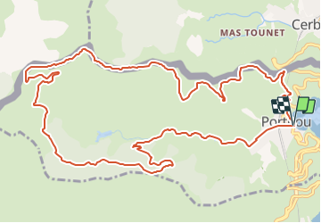
![](/images/other/stat-length.png)
![Tocht Te voet Portbou - Portbou-Querroig - Photo](https://media.geolcdn.com/t/1900/400/5e9eee19-3ccd-4d07-87b9-976ee82f4b87.jpeg&format=pjpeg&maxdim=2)
Portbou-Querroig
SityTrail - itinéraires balisés pédestres
Tous les sentiers balisés d’Europe GUIDE+
![Lengte](/images/other/stat-length.png)
![Max. hoogte](https://static1.geolcdn.com/siteimages/upload/files/1508320355ic_sort_altitude_max_24dp.png)
![Positief hoogteverschil](https://static1.geolcdn.com/siteimages/upload/files/1508320355ic_sort_den_pos_24dp.png)
![Km-Effort](/images/other/stat-length.png)
![Min. hoogte](https://static1.geolcdn.com/siteimages/upload/files/1508320355ic_sort_altitude_min_24dp.png)
![Negatief hoogteverschil](https://static1.geolcdn.com/siteimages/upload/files/1508320355ic_sort_den_neg_24dp.png)
![Boucle](https://static1.geolcdn.com/siteimages/upload/files/16400158638029165_repeat_loop_refresh_sync_direction_icon.png)
![Te voet](https://static1.geolcdn.com/sitytour/trail-icons/100.png)
5h48
Moeilijkheid : Medium
![Scan deze QR-code om de tocht te openen in de SityTrail-applicatie](https://capi.geolives.com/qq0zvz2zws4bq2lad0pu/sitytour/trails/3110423/qr.png?size=200)
Gratisgps-wandelapplicatie
Over ons
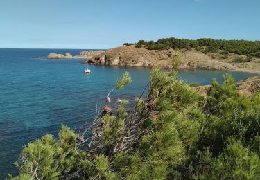
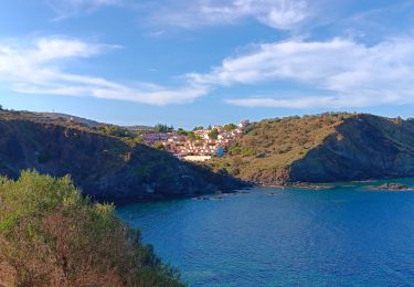
Tocht Te voet van 16 km beschikbaar op Catalonië, Gerona, Portbou. Deze tocht wordt voorgesteld door SityTrail - itinéraires balisés pédestres.
Beschrijving
Excursions i rutes itineraris marcats: GR,via verda, parcs naturals, saludables...sortides amb nens
Website: https://www.itinerannia.net/ca/itineraris/itinerari-de-portbou-a-querroig-ruta-5-alt-emporda/
Plaatsbepaling
Opmerkingen
Wandeltochten in de omgeving
![Tocht Stappen Portbou - Sentier du Littoral : Cerbère à Port-Vendres - Photo](https://media.geolcdn.com/t/375/260/a5cd91fe-c1c7-440b-b389-381c70fd5be6.jpg&format=jpg&maxdim=2)
![Stappen Stappen](https://static1.geolcdn.com/sitytour/trail-icons/101.png)
Stappen
![](/images/other/stat-length.png)
![](https://static1.geolcdn.com/siteimages/upload/files/16400158638029165_repeat_loop_refresh_sync_direction_icon.png)
![Tocht Stappen Cerbère - Cerbère - Cap Cerbère - Plage de Peyrefite - 12.9km 510m 4h10 (40mn) - 2018 09 06 - Photo](https://media.geolcdn.com/t/375/260/ext.jpg?maxdim=2&url=https%3A%2F%2Fservices.sitytrail.com%2FGeolivesWS%2FDownloadMedia.ashx%3FTrailID%3D1042062%26Media%3Dfix__20180906120805.jpg)
![Stappen Stappen](https://static1.geolcdn.com/sitytour/trail-icons/101.png)
Stappen
![](/images/other/stat-length.png)
![](https://static1.geolcdn.com/siteimages/upload/files/16400158638029165_repeat_loop_refresh_sync_direction_icon.png)
![Tocht Stappen Cerbère - Cerbère Llança Litoral2 - Photo](https://media.geolcdn.com/t/375/260/44d797c9-8959-413d-94ff-8b549c04462b.jpg&format=jpg&maxdim=2)
![Stappen Stappen](https://static1.geolcdn.com/sitytour/trail-icons/101.png)
Stappen
![](/images/other/stat-length.png)
![](https://static1.geolcdn.com/siteimages/upload/files/16400158638029165_repeat_loop_refresh_sync_direction_icon.png)
![Tocht Stappen Cerbère - Cerbère Pyrénées Orientales - Photo](https://media.geolcdn.com/t/375/260/3e21330b-2367-4dbb-ae88-70bda81c2798.jpg&format=jpg&maxdim=2)
![Stappen Stappen](https://static1.geolcdn.com/sitytour/trail-icons/101.png)
Stappen
![](/images/other/stat-length.png)
![](https://static1.geolcdn.com/siteimages/upload/files/16400158638029165_repeat_loop_refresh_sync_direction_icon.png)
![Tocht Stappen Cerbère - vilk1g3 des aloès - car Cerbère / retour - Photo](https://media.geolcdn.com/t/375/260/77f470b9-c817-4e2d-ac3c-9f15bd147309.jpg&format=jpg&maxdim=2)
![Stappen Stappen](https://static1.geolcdn.com/sitytour/trail-icons/101.png)
Stappen
![](/images/other/stat-length.png)
![](https://static1.geolcdn.com/siteimages/upload/files/16400158638029165_repeat_loop_refresh_sync_direction_icon.png)
![Tocht Stappen Cerbère - village des aloès - cap cerbère/ aller-retour - Photo](https://media.geolcdn.com/t/375/260/99b988ef-e741-49da-8c8b-15628b90e96c.jpg&format=jpg&maxdim=2)
![Stappen Stappen](https://static1.geolcdn.com/sitytour/trail-icons/101.png)
Stappen
![](/images/other/stat-length.png)
![](https://static1.geolcdn.com/siteimages/upload/files/16400158638029165_repeat_loop_refresh_sync_direction_icon.png)
![Tocht Stappen Cerbère - Cerbère cerbère - Photo](https://media.geolcdn.com/t/375/260/75d5f2f7-d7c5-48ac-95e9-ee7419da947f.jpg&format=jpg&maxdim=2)
![Stappen Stappen](https://static1.geolcdn.com/sitytour/trail-icons/101.png)
Stappen
![](/images/other/stat-length.png)
![](https://static1.geolcdn.com/siteimages/upload/files/16400158638029165_repeat_loop_refresh_sync_direction_icon.png)
![Tocht Stappen Cerbère - cerbère. cap cerbère. coll dels belitras . puig dels frères. cerbère - Photo](https://media.geolcdn.com/t/375/260/67db68e1-9235-4b9f-99aa-37dc1cba8aff.jpg&format=jpg&maxdim=2)
![Stappen Stappen](https://static1.geolcdn.com/sitytour/trail-icons/101.png)
Stappen
![](/images/other/stat-length.png)
![](https://static1.geolcdn.com/siteimages/upload/files/16400158638029165_repeat_loop_refresh_sync_direction_icon.png)
![Tocht Stappen Cerbère - Cerbère chemin de la frigio lette - Photo](https://media.geolcdn.com/t/375/260/25e72dc4-34c5-4c60-8a3c-ac2a5c2303db.jpg&format=jpg&maxdim=2)
![Stappen Stappen](https://static1.geolcdn.com/sitytour/trail-icons/101.png)
Stappen
![](/images/other/stat-length.png)
![](https://static1.geolcdn.com/siteimages/upload/files/16400158638029165_repeat_loop_refresh_sync_direction_icon.png)