Tocht Te voet Olivella - Castell Vell d'Olivella - Photo

Castell Vell d'Olivella

Tous les sentiers balisés d’Europe GUIDE+

© OpenStreetMap contributors
Lengte
Lengte
5,7 km
Max. hoogte
Max. hoogte
294 m
Positief hoogteverschil
207 m
Km-Effort
Km-Effort  
8,4 km
Min. hoogte
Min. hoogte
144 m
Negatief hoogteverschil
210 m
Boucle
Boucle
Ja
Markering
Markering
Datum van aanmaak :
2022-02-14 15:37:20.872
Laatste wijziging :
2022-02-14 15:37:20.872

(0 Bericht)

Te voet
Te voet
1h54
Moeilijkheid : Gemakkelijk

Scan deze QR-code om de tocht te openen in de SityTrail-applicatie

Gratisgps-wandelapplicatie

Logo SityTrail SityTrail

IGN / Geografische instituten

SityTrail uit de App Store downloaden SityTrail uit Google Play downloaden

Logo SityTrail SityTrail World

De wereld gaat voor u open

SityTrail uit de App Store downloaden SityTrail uit Google Play downloaden SityTrail op Huawei AppGallery downloaden

Over ons

Tocht Te voet van 5,7 km beschikbaar op Catalonië, Barcelona, Olivella. Deze tocht wordt voorgesteld door SityTrail - itinéraires balisés pédestres.

Beschrijving

Trail created by Diputació de Barcelona.


Website: https://itineraris-senyalitzats.diba.cat/dibaparcs/routes/view/sl-c-100-castell-vell-d-olivella

Hoogteprofiel

Foto's

Plaatsbepaling

Land:
Spain
Regio :
Catalonië
Departement/Provincie :
Barcelona
Gemeente :
Olivella
Locatie:
Unknown
Vertrek:(UTM)
400581 ; 4573884 (31T) N.

Wandeltochten in de omgeving

Tocht Quad Olivella - Geert 01 - Photo
Quad
DecockR

Quad

Gemakkelijk
Olivella, Catalonië, Barcelona, Spain
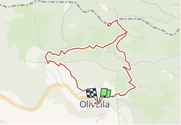
53 km | 66 km-effort
2h 33min
Neen


Sluiten
Mijn abonnementen