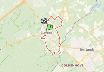
![](/images/other/stat-length.png)
![Tocht Te voet Apeldoorn - Loenense Enkenpad - Photo](https://media.geolcdn.com/t/1900/400/3c5b25f2-3fcc-4c0f-8b21-7f158c919cab.jpeg&format=pjpeg&maxdim=2)
Loenense Enkenpad
SityTrail - itinéraires balisés pédestres
Tous les sentiers balisés d’Europe GUIDE+
![Lengte](/images/other/stat-length.png)
![Max. hoogte](https://static1.geolcdn.com/siteimages/upload/files/1508320355ic_sort_altitude_max_24dp.png)
![Positief hoogteverschil](https://static1.geolcdn.com/siteimages/upload/files/1508320355ic_sort_den_pos_24dp.png)
![Km-Effort](/images/other/stat-length.png)
![Min. hoogte](https://static1.geolcdn.com/siteimages/upload/files/1508320355ic_sort_altitude_min_24dp.png)
![Negatief hoogteverschil](https://static1.geolcdn.com/siteimages/upload/files/1508320355ic_sort_den_neg_24dp.png)
![Boucle](https://static1.geolcdn.com/siteimages/upload/files/16400158638029165_repeat_loop_refresh_sync_direction_icon.png)
![Te voet](https://static1.geolcdn.com/sitytour/trail-icons/100.png)
2h24
Moeilijkheid : Gemakkelijk
![Scan deze QR-code om de tocht te openen in de SityTrail-applicatie](https://capi.geolives.com/qq0zvz2zws4bq2lad0pu/sitytour/trails/3110399/qr.png?size=200)
Gratisgps-wandelapplicatie
Over ons
Tocht Te voet van 9,3 km beschikbaar op Gelderland, Onbekend, Apeldoorn. Deze tocht wordt voorgesteld door SityTrail - itinéraires balisés pédestres.
Beschrijving
Trail created by klompenpaden.nl.
Het wandelpad loopt gedeeltelijk over particulier terrein, waar soms vee loopt. Om de dieren niet te verstoren en verspreiding van dierziekten te voorkomen zijn honden verboden.
Symbol: Bruine klompen / Brown wooden shoes
Website: https://klompenpaden.nl/klompenpad/loenense-enkenpad/
Plaatsbepaling
Opmerkingen
Wandeltochten in de omgeving
![Tocht Te voet Apeldoorn - Albapad - Photo](https://media.geolcdn.com/t/375/260/8c7e50c9-acb6-438d-a3e2-df78b5be7afe.jpeg&format=jpg&maxdim=2)
![Te voet Te voet](https://static1.geolcdn.com/sitytour/trail-icons/100.png)
Te voet
![](/images/other/stat-length.png)
![](https://static1.geolcdn.com/siteimages/upload/files/16400158638029165_repeat_loop_refresh_sync_direction_icon.png)
![Tocht Te voet Apeldoorn - Deelerwoud - Blauw - Photo](https://media.geolcdn.com/t/375/260/8d358043-249e-47c4-b472-94e6d95606b2.jpeg&format=jpg&maxdim=2)
![Te voet Te voet](https://static1.geolcdn.com/sitytour/trail-icons/100.png)
Te voet
![](/images/other/stat-length.png)
![](https://static1.geolcdn.com/siteimages/upload/files/16400158638029165_repeat_loop_refresh_sync_direction_icon.png)
![Tocht Te voet Apeldoorn - Welkom op de Loenermark! Zwarte route - Photo](https://media.geolcdn.com/t/375/260/10811004-b4fa-4eda-a748-884a8844bfad.jpeg&format=jpg&maxdim=2)
![Te voet Te voet](https://static1.geolcdn.com/sitytour/trail-icons/100.png)
Te voet
![](/images/other/stat-length.png)
![](https://static1.geolcdn.com/siteimages/upload/files/16400158638029165_repeat_loop_refresh_sync_direction_icon.png)
![Tocht Te voet Apeldoorn - Welkom op de Loenermark! Blauwe route - Photo](https://media.geolcdn.com/t/375/260/10811004-b4fa-4eda-a748-884a8844bfad.jpeg&format=jpg&maxdim=2)
![Te voet Te voet](https://static1.geolcdn.com/sitytour/trail-icons/100.png)
Te voet
![](/images/other/stat-length.png)
![](https://static1.geolcdn.com/siteimages/upload/files/16400158638029165_repeat_loop_refresh_sync_direction_icon.png)
![Tocht Te voet Brummen - Dwars door Gelderland (17) - Photo](https://media.geolcdn.com/t/375/260/5073ca41-17a8-411f-ab5c-9a92f3d474d4.jpeg&format=jpg&maxdim=2)
![Te voet Te voet](https://static1.geolcdn.com/sitytour/trail-icons/100.png)
Te voet
![](/images/other/stat-length.png)
![](https://static1.geolcdn.com/siteimages/upload/files/16400158638029165_repeat_loop_refresh_sync_direction_icon.png)
![Tocht Te voet Rheden - Dwars door Gelderland (16) - Photo](https://media.geolcdn.com/t/375/260/9668913b-94cf-4fa2-82c3-acaa17e5951a.jpeg&format=jpg&maxdim=2)
![Te voet Te voet](https://static1.geolcdn.com/sitytour/trail-icons/100.png)
Te voet
![](/images/other/stat-length.png)
![](https://static1.geolcdn.com/siteimages/upload/files/16400158638029165_repeat_loop_refresh_sync_direction_icon.png)
![Tocht Stappen Apeldoorn - Reeëndal in Loenen (gld) - Photo](https://media.geolcdn.com/t/375/260/a36c921c-a500-4542-8d1f-aa8f8e392d17.jpg&format=jpg&maxdim=2)
![Stappen Stappen](https://static1.geolcdn.com/sitytour/trail-icons/101.png)
Stappen
![](/images/other/stat-length.png)
![](https://static1.geolcdn.com/siteimages/upload/files/16400158638029165_repeat_loop_refresh_sync_direction_icon.png)
![Tocht Fiets Brummen - Gelderland - Veluwezoomtocht - Photo](https://media.geolcdn.com/t/375/260/ext.jpg?maxdim=2&url=https%3A%2F%2Fstatic1.geolcdn.com%2Fsiteimages%2Fupload%2Ffiles%2F1524743154velo.jpg)
![Fiets Fiets](https://static1.geolcdn.com/sitytour/trail-icons/200.png)
Fiets
![](/images/other/stat-length.png)
![](https://static1.geolcdn.com/siteimages/upload/files/16400158638029165_repeat_loop_refresh_sync_direction_icon.png)
![Tocht Fiets Apeldoorn - f-gelderland-loenen-posbank - Photo](https://media.geolcdn.com/t/375/260/ext.jpg?maxdim=2&url=https%3A%2F%2Fstatic1.geolcdn.com%2Fsiteimages%2Fupload%2Ffiles%2F1524743154velo.jpg)
![Fiets Fiets](https://static1.geolcdn.com/sitytour/trail-icons/200.png)
Fiets
![](/images/other/stat-length.png)
![](https://static1.geolcdn.com/siteimages/upload/files/16400158638029165_repeat_loop_refresh_sync_direction_icon.png)