![](/images/other/stat-length.png)
![Tocht Te voet Valdemanco - Ruta del Granito - Photo](https://media.geolcdn.com/t/1900/400/7150f553-a39c-4e6b-8ad0-a3ef552d9d1b.jpeg&format=pjpeg&maxdim=2)
Ruta del Granito
SityTrail - itinéraires balisés pédestres
Tous les sentiers balisés d’Europe GUIDE+
![Lengte](/images/other/stat-length.png)
Lengte
9 km
![Max. hoogte](https://static1.geolcdn.com/siteimages/upload/files/1508320355ic_sort_altitude_max_24dp.png)
Max. hoogte
1197 m
![Positief hoogteverschil](https://static1.geolcdn.com/siteimages/upload/files/1508320355ic_sort_den_pos_24dp.png)
Positief hoogteverschil
221 m
![Km-Effort](/images/other/stat-length.png)
Km-Effort
12 km
![Min. hoogte](https://static1.geolcdn.com/siteimages/upload/files/1508320355ic_sort_altitude_min_24dp.png)
Min. hoogte
1002 m
![Negatief hoogteverschil](https://static1.geolcdn.com/siteimages/upload/files/1508320355ic_sort_den_neg_24dp.png)
Negatief hoogteverschil
212 m
![Boucle](https://static1.geolcdn.com/siteimages/upload/files/16400158638029165_repeat_loop_refresh_sync_direction_icon.png)
Boucle
Ja
Markering
Datum van aanmaak :
2022-02-14 15:29:55.549
Laatste wijziging :
2022-02-14 15:29:55.549
![Te voet](https://static1.geolcdn.com/sitytour/trail-icons/100.png)
2h43
Moeilijkheid : Gemakkelijk
![Scan deze QR-code om de tocht te openen in de SityTrail-applicatie](https://capi.geolives.com/qq0zvz2zws4bq2lad0pu/sitytour/trails/3110241/qr.png?size=200)
Gratisgps-wandelapplicatie
Over ons
Tocht Te voet van 9 km beschikbaar op Comunidad de Madrid, Onbekend, Valdemanco. Deze tocht wordt voorgesteld door SityTrail - itinéraires balisés pédestres.
Beschrijving
Website: http://www.valdemanco.org/site/wp-content/uploads/2019/03/Ruta_Granito.pdf
Plaatsbepaling
Land:
Spain
Regio :
Comunidad de Madrid
Departement/Provincie :
Onbekend
Gemeente :
Valdemanco
Locatie:
Unknown
Vertrek:(Dec)
Vertrek:(UTM)
444436 ; 4524695 (30T) N.
Opmerkingen
Wandeltochten in de omgeving
![Tocht Te voet Patones - Ruta 2: Vuelta al Cabezo - Photo](https://media.geolcdn.com/t/375/260/80303621-1a36-4c2e-851d-dc6422f4229b.jpeg&format=jpg&maxdim=2)
![Te voet Te voet](https://static1.geolcdn.com/sitytour/trail-icons/100.png)
Ruta 2: Vuelta al Cabezo
Te voet
Gemakkelijk
Patones,
Comunidad de Madrid,
Onbekend,
Spain
![](/images/other/stat-length.png)
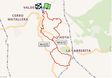
6,6 km | 10,5 km-effort
2h 22min
![](https://static1.geolcdn.com/siteimages/upload/files/16400158638029165_repeat_loop_refresh_sync_direction_icon.png)
Ja
![Tocht Te voet Patones - Ruta 1: Subida al Cancho de la Cabeza por el Arroyo de Patones - Photo](https://media.geolcdn.com/t/375/260/a1a0f8f0-8b91-49bc-a1de-bdb9005ea52d.jpeg&format=jpg&maxdim=2)
![Te voet Te voet](https://static1.geolcdn.com/sitytour/trail-icons/100.png)
Ruta 1: Subida al Cancho de la Cabeza por el Arroyo de Patones
Te voet
Gemakkelijk
Patones,
Comunidad de Madrid,
Onbekend,
Spain
![](/images/other/stat-length.png)
12,4 km | 19,6 km-effort
4h 27min
![](https://static1.geolcdn.com/siteimages/upload/files/16400158638029165_repeat_loop_refresh_sync_direction_icon.png)
Ja
![Tocht Te voet Canencia - Senda del Arroyo del Sestil del Maíllo y de la Ladera de Mojonavalle - Photo](https://media.geolcdn.com/t/375/260/f22f805a-f104-4f57-ac21-062d0d0b219f.jpeg&format=jpg&maxdim=2)
![Te voet Te voet](https://static1.geolcdn.com/sitytour/trail-icons/100.png)
Senda del Arroyo del Sestil del Maíllo y de la Ladera de Mojonavalle
Te voet
Gemakkelijk
Canencia,
Comunidad de Madrid,
Onbekend,
Spain
![](/images/other/stat-length.png)
7,5 km | 10,9 km-effort
2h 28min
![](https://static1.geolcdn.com/siteimages/upload/files/16400158638029165_repeat_loop_refresh_sync_direction_icon.png)
Ja
![Tocht Te voet Uceda - Senda 2: Remontando el Lozoya hasta la Presa de la Parra - Photo](https://media.geolcdn.com/t/375/260/b095a704-2cbf-4150-8fdf-8fc340d034fa.jpeg&format=jpg&maxdim=2)
![Te voet Te voet](https://static1.geolcdn.com/sitytour/trail-icons/100.png)
Senda 2: Remontando el Lozoya hasta la Presa de la Parra
Te voet
Gemakkelijk
Uceda,
Castilië-La Mancha,
Guadalajara,
Spain
![](/images/other/stat-length.png)
7,7 km | 9,3 km-effort
2h 6min
![](https://static1.geolcdn.com/siteimages/upload/files/16400158638029165_repeat_loop_refresh_sync_direction_icon.png)
Neen
![Tocht Te voet Manzanares el Real - [RV 22] Garganta de la Camorza - Photo](https://media.geolcdn.com/t/375/260/90bbe6fd-f585-4379-a530-b8909ea4cd65.jpeg&format=jpg&maxdim=2)
![Te voet Te voet](https://static1.geolcdn.com/sitytour/trail-icons/100.png)
[RV 22] Garganta de la Camorza
Te voet
Gemakkelijk
Manzanares el Real,
Comunidad de Madrid,
Onbekend,
Spain
![](/images/other/stat-length.png)
5,5 km | 7 km-effort
1h 35min
![](https://static1.geolcdn.com/siteimages/upload/files/16400158638029165_repeat_loop_refresh_sync_direction_icon.png)
Neen
![Tocht Te voet Manzanares el Real - [RV 20] Collado de la Dehesilla - Photo](https://media.geolcdn.com/t/375/260/14f6a6c8-b3ec-4ba1-b1d6-fe22cff41c84.jpeg&format=jpg&maxdim=2)
![Te voet Te voet](https://static1.geolcdn.com/sitytour/trail-icons/100.png)
[RV 20] Collado de la Dehesilla
Te voet
Gemakkelijk
Manzanares el Real,
Comunidad de Madrid,
Onbekend,
Spain
![](/images/other/stat-length.png)
3,9 km | 8 km-effort
1h 48min
![](https://static1.geolcdn.com/siteimages/upload/files/16400158638029165_repeat_loop_refresh_sync_direction_icon.png)
Neen
![Tocht Te voet Manzanares el Real - [RV 21] Circular Collado Cabrón - Photo](https://media.geolcdn.com/t/375/260/08dd2715-3a1e-44a0-9842-91629ab6f415.jpeg&format=jpg&maxdim=2)
![Te voet Te voet](https://static1.geolcdn.com/sitytour/trail-icons/100.png)
[RV 21] Circular Collado Cabrón
Te voet
Gemakkelijk
Manzanares el Real,
Comunidad de Madrid,
Onbekend,
Spain
![](/images/other/stat-length.png)
5,4 km | 8,9 km-effort
2h 1min
![](https://static1.geolcdn.com/siteimages/upload/files/16400158638029165_repeat_loop_refresh_sync_direction_icon.png)
Ja
![Tocht Te voet Garganta de los Montes - ES-PR-29 - Photo](https://media.geolcdn.com/t/375/260/d05d637c-a197-48c4-9a9c-3f28707573a8.jpeg&format=jpg&maxdim=2)
![Te voet Te voet](https://static1.geolcdn.com/sitytour/trail-icons/100.png)
ES-PR-29
Te voet
Medium
Garganta de los Montes,
Comunidad de Madrid,
Onbekend,
Spain
![](/images/other/stat-length.png)
21 km | 27 km-effort
6h 12min
![](https://static1.geolcdn.com/siteimages/upload/files/16400158638029165_repeat_loop_refresh_sync_direction_icon.png)
Ja
![Tocht Te voet Manzanares el Real - [RV 23] Collado Quebrantahuesos - Photo](https://media.geolcdn.com/t/375/260/52736da5-4c36-4bd1-8ff5-641fc5706541.jpeg&format=jpg&maxdim=2)
![Te voet Te voet](https://static1.geolcdn.com/sitytour/trail-icons/100.png)
[RV 23] Collado Quebrantahuesos
Te voet
Gemakkelijk
Manzanares el Real,
Comunidad de Madrid,
Onbekend,
Spain
![](/images/other/stat-length.png)
3,9 km | 6,1 km-effort
1h 22min
![](https://static1.geolcdn.com/siteimages/upload/files/16400158638029165_repeat_loop_refresh_sync_direction_icon.png)
Neen