![](/images/other/stat-length.png)
![Tocht Te voet Montaria - Trilho da Montanha Sagrada - Photo](https://media.geolcdn.com/t/1900/400/ext.pjpeg?maxdim=2&url=https%3A%2F%2Fmedia.geolcdn.com%2Ff%2F186df273-c578-422b-97f2-340b57714639.jpeg)
Trilho da Montanha Sagrada
SityTrail - itinéraires balisés pédestres
Tous les sentiers balisés d’Europe PRO
![Lengte](/images/other/stat-length.png)
Lengte
19,1 km
![Max. hoogte](https://static1.geolcdn.com/siteimages/upload/files/1508320355ic_sort_altitude_max_24dp.png)
Max. hoogte
792 m
![Positief hoogteverschil](https://static1.geolcdn.com/siteimages/upload/files/1508320355ic_sort_den_pos_24dp.png)
Positief hoogteverschil
637 m
![Km-Effort](/images/other/stat-length.png)
Km-Effort
28 km
![Min. hoogte](https://static1.geolcdn.com/siteimages/upload/files/1508320355ic_sort_altitude_min_24dp.png)
Min. hoogte
281 m
![Negatief hoogteverschil](https://static1.geolcdn.com/siteimages/upload/files/1508320355ic_sort_den_neg_24dp.png)
Negatief hoogteverschil
636 m
![Boucle](https://static1.geolcdn.com/siteimages/upload/files/16400158638029165_repeat_loop_refresh_sync_direction_icon.png)
Boucle
Ja
Markering
Datum van aanmaak :
2022-02-14 14:53:03.294
Laatste wijziging :
2022-02-14 14:53:03.294
![Te voet](https://static1.geolcdn.com/sitytour/trail-icons/100.png)
6h15
Moeilijkheid : Medium
![Scan deze QR-code om de tocht te openen in de SityTrail-applicatie](https://capi.geolives.com/qq0zvz2zws4bq2lad0pu/sitytour/trails/3109365/qr.png?size=200)
Gratisgps-wandelapplicatie
Over ons
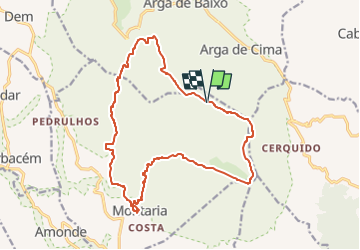
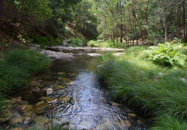
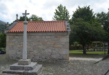
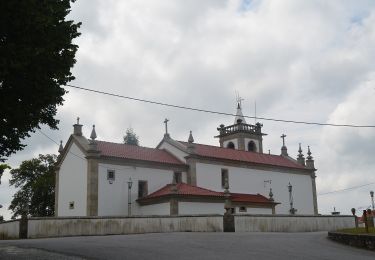
Tocht Te voet van 19,1 km beschikbaar op Norte, Viana do Castelo, Montaria. Deze tocht wordt voorgesteld door SityTrail - itinéraires balisés pédestres.
Beschrijving
Website: http://www.cm-viana-castelo.pt/pt/percursos-pedestres-ciclovia
Plaatsbepaling
Land:
Portugal
Regio :
Norte
Departement/Provincie :
Viana do Castelo
Gemeente :
Montaria
Locatie:
Unknown
Vertrek:(Dec)
Vertrek:(UTM)
524493 ; 4629685 (29T) N.
Opmerkingen
Wandeltochten in de omgeving
![Tocht Te voet - Trilho do Lobo Atlântico - Photo](https://media.geolcdn.com/t/375/260/ext.jpg?maxdim=2&url=https%3A%2F%2Fmedia.geolcdn.com%2Ff%2F5ba811a4-fc38-43d0-b473-94c34ec2d7c8.jpeg)
![Te voet Te voet](https://static1.geolcdn.com/sitytour/trail-icons/100.png)
Trilho do Lobo Atlântico
Te voet
Gemakkelijk
,
Norte,
Viana do Castelo,
Portugal
![](/images/other/stat-length.png)
5 km | 9,2 km-effort
2h 5min
![](https://static1.geolcdn.com/siteimages/upload/files/16400158638029165_repeat_loop_refresh_sync_direction_icon.png)
Neen
![Tocht Te voet Estorãos - Percurso do Cerquido - Photo](https://media.geolcdn.com/t/375/260/ext.jpg?maxdim=2&url=https%3A%2F%2Fmedia.geolcdn.com%2Ff%2Fb5326e96-b9f3-40e7-b2ce-f3792d9a22c0.jpeg)
![Te voet Te voet](https://static1.geolcdn.com/sitytour/trail-icons/100.png)
Percurso do Cerquido
Te voet
Gemakkelijk
Estorãos,
Norte,
Viana do Castelo,
Portugal
![](/images/other/stat-length.png)
9,6 km | 14,8 km-effort
3h 21min
![](https://static1.geolcdn.com/siteimages/upload/files/16400158638029165_repeat_loop_refresh_sync_direction_icon.png)
Neen
![Tocht Te voet Estorãos - Percurso da Água - Photo](https://media.geolcdn.com/t/375/260/ext.jpg?maxdim=2&url=https%3A%2F%2Fmedia.geolcdn.com%2Ff%2Fffe2547d-0da3-40ae-99ba-c29258f17f28.jpeg)
![Te voet Te voet](https://static1.geolcdn.com/sitytour/trail-icons/100.png)
Percurso da Água
Te voet
Gemakkelijk
Estorãos,
Norte,
Viana do Castelo,
Portugal
![](/images/other/stat-length.png)
12,1 km | 13,7 km-effort
3h 7min
![](https://static1.geolcdn.com/siteimages/upload/files/16400158638029165_repeat_loop_refresh_sync_direction_icon.png)
Neen
![Tocht Te voet Estorãos - Rota da Azenha - Photo](https://media.geolcdn.com/t/375/260/ext.jpg?maxdim=2&url=https%3A%2F%2Fmedia.geolcdn.com%2Ff%2Fc0beb203-4962-49e6-ae66-0755f3c71f4e.jpeg)
![Te voet Te voet](https://static1.geolcdn.com/sitytour/trail-icons/100.png)
Rota da Azenha
Te voet
Gemakkelijk
Estorãos,
Norte,
Viana do Castelo,
Portugal
![](/images/other/stat-length.png)
4 km | 4,5 km-effort
1h 1min
![](https://static1.geolcdn.com/siteimages/upload/files/16400158638029165_repeat_loop_refresh_sync_direction_icon.png)
Neen
![Tocht Te voet Arga (Baixo, Cima e São João) - Trilho da Pedra Alçada - Photo](https://media.geolcdn.com/t/375/260/ext.jpg?maxdim=2&url=https%3A%2F%2Fmedia.geolcdn.com%2Ff%2F35f4f575-4307-41e9-b4f2-ce1f41db9ace.jpeg)
![Te voet Te voet](https://static1.geolcdn.com/sitytour/trail-icons/100.png)
Trilho da Pedra Alçada
Te voet
Gemakkelijk
Arga (Baixo, Cima e São João),
Norte,
Viana do Castelo,
Portugal
![](/images/other/stat-length.png)
9,8 km | 14,7 km-effort
3h 20min
![](https://static1.geolcdn.com/siteimages/upload/files/16400158638029165_repeat_loop_refresh_sync_direction_icon.png)
Ja
![Tocht Te voet Arga (Baixo, Cima e São João) - Trilho do Cabeço do Meio Dia - Photo](https://media.geolcdn.com/t/375/260/ext.jpg?maxdim=2&url=https%3A%2F%2Fmedia.geolcdn.com%2Ff%2Ff0b40405-8f08-4ee9-92db-a1f47da7cdbb.jpeg)
![Te voet Te voet](https://static1.geolcdn.com/sitytour/trail-icons/100.png)
Trilho do Cabeço do Meio Dia
Te voet
Gemakkelijk
Arga (Baixo, Cima e São João),
Norte,
Viana do Castelo,
Portugal
![](/images/other/stat-length.png)
4,9 km | 6,4 km-effort
1h 27min
![](https://static1.geolcdn.com/siteimages/upload/files/16400158638029165_repeat_loop_refresh_sync_direction_icon.png)
Neen
![Tocht Te voet Montaria - Trilho do Pôr-do-Sol - Photo](https://media.geolcdn.com/t/375/260/ext.jpg?maxdim=2&url=https%3A%2F%2Fmedia.geolcdn.com%2Ff%2F4df6f8e3-0b1a-453b-a51c-bbce950e9ff0.jpeg)
![Te voet Te voet](https://static1.geolcdn.com/sitytour/trail-icons/100.png)
Trilho do Pôr-do-Sol
Te voet
Gemakkelijk
Montaria,
Norte,
Viana do Castelo,
Portugal
![](/images/other/stat-length.png)
10,1 km | 14,8 km-effort
3h 21min
![](https://static1.geolcdn.com/siteimages/upload/files/16400158638029165_repeat_loop_refresh_sync_direction_icon.png)
Ja
![Tocht Te voet Amonde - Trilho do Pincho - Photo](https://media.geolcdn.com/t/375/260/ext.jpg?maxdim=2&url=https%3A%2F%2Fmedia.geolcdn.com%2Ff%2F586db393-058d-4aa2-898c-bca182cc7692.jpeg)
![Te voet Te voet](https://static1.geolcdn.com/sitytour/trail-icons/100.png)
Trilho do Pincho
Te voet
Gemakkelijk
Amonde,
Norte,
Viana do Castelo,
Portugal
![](/images/other/stat-length.png)
4,1 km | 5,7 km-effort
1h 18min
![](https://static1.geolcdn.com/siteimages/upload/files/16400158638029165_repeat_loop_refresh_sync_direction_icon.png)
Neen
![Tocht Te voet Montaria - Trilho dos Pastores - Photo](https://media.geolcdn.com/t/375/260/ext.jpg?maxdim=2&url=https%3A%2F%2Fmedia.geolcdn.com%2Ff%2Fa9568a3f-fdc6-42b9-a9a7-a88f1642f77c.jpeg)
![Te voet Te voet](https://static1.geolcdn.com/sitytour/trail-icons/100.png)
Trilho dos Pastores
Te voet
Medium
Montaria,
Norte,
Viana do Castelo,
Portugal
![](/images/other/stat-length.png)
14,7 km | 23 km-effort
5h 13min
![](https://static1.geolcdn.com/siteimages/upload/files/16400158638029165_repeat_loop_refresh_sync_direction_icon.png)
Ja