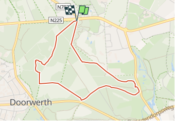
![](/images/other/stat-length.png)
![Tocht Te voet Renkum - Hoog Oorsprong-Zilverberg-route - Photo](https://media.geolcdn.com/t/1900/400/4702f4c7-6a19-4ca0-b9b0-1f08d41c7ac1.jpeg&format=pjpeg&maxdim=2)
Hoog Oorsprong-Zilverberg-route
SityTrail - itinéraires balisés pédestres
Tous les sentiers balisés d’Europe GUIDE+
![Lengte](/images/other/stat-length.png)
![Max. hoogte](https://static1.geolcdn.com/siteimages/upload/files/1508320355ic_sort_altitude_max_24dp.png)
![Positief hoogteverschil](https://static1.geolcdn.com/siteimages/upload/files/1508320355ic_sort_den_pos_24dp.png)
![Km-Effort](/images/other/stat-length.png)
![Min. hoogte](https://static1.geolcdn.com/siteimages/upload/files/1508320355ic_sort_altitude_min_24dp.png)
![Negatief hoogteverschil](https://static1.geolcdn.com/siteimages/upload/files/1508320355ic_sort_den_neg_24dp.png)
![Boucle](https://static1.geolcdn.com/siteimages/upload/files/16400158638029165_repeat_loop_refresh_sync_direction_icon.png)
![Te voet](https://static1.geolcdn.com/sitytour/trail-icons/100.png)
1h04
Moeilijkheid : Gemakkelijk
![Scan deze QR-code om de tocht te openen in de SityTrail-applicatie](https://capi.geolives.com/qq0zvz2zws4bq2lad0pu/sitytour/trails/3108764/qr.png?size=200)
Gratisgps-wandelapplicatie
Over ons
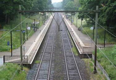
Tocht Te voet van 3,9 km beschikbaar op Gelderland, Onbekend, Renkum. Deze tocht wordt voorgesteld door SityTrail - itinéraires balisés pédestres.
Beschrijving
Meer dan 100 prachtige natuurgebieden, kastelen en landgoederen in Gelderland zijn aan de zorg toevertrouwd van Geldersch Landschap & Kasteelen.
Website: https://www.glk.nl/82/locatie/?locatie=9
Plaatsbepaling
Opmerkingen
Wandeltochten in de omgeving
![Tocht Te voet Ede - Buunderkamp - Rode pijl - Photo](https://media.geolcdn.com/t/375/260/968a0081-d191-41d7-a424-5be7a0106691.jpeg&format=jpg&maxdim=2)
![Te voet Te voet](https://static1.geolcdn.com/sitytour/trail-icons/100.png)
Te voet
![](/images/other/stat-length.png)
![](https://static1.geolcdn.com/siteimages/upload/files/16400158638029165_repeat_loop_refresh_sync_direction_icon.png)
![Tocht Te voet Renkum - Molenbeeksepad - Photo](https://media.geolcdn.com/t/375/260/be8ca94d-f66a-461e-9184-fada35dc0854.jpeg&format=jpg&maxdim=2)
![Te voet Te voet](https://static1.geolcdn.com/sitytour/trail-icons/100.png)
Te voet
![](/images/other/stat-length.png)
![](https://static1.geolcdn.com/siteimages/upload/files/16400158638029165_repeat_loop_refresh_sync_direction_icon.png)
![Tocht Te voet Renkum - Nederrijnsepad - Photo](https://media.geolcdn.com/t/375/260/a4953e17-1ca9-4629-bde4-56e0bcb9361f.jpeg&format=jpg&maxdim=2)
![Te voet Te voet](https://static1.geolcdn.com/sitytour/trail-icons/100.png)
Te voet
![](/images/other/stat-length.png)
![](https://static1.geolcdn.com/siteimages/upload/files/16400158638029165_repeat_loop_refresh_sync_direction_icon.png)
![Tocht Te voet Renkum - Dorenweertsepad - Photo](https://media.geolcdn.com/t/375/260/b7c380c3-a109-4b9c-9971-85e75dba5716.jpeg&format=jpg&maxdim=2)
![Te voet Te voet](https://static1.geolcdn.com/sitytour/trail-icons/100.png)
Te voet
![](/images/other/stat-length.png)
![](https://static1.geolcdn.com/siteimages/upload/files/16400158638029165_repeat_loop_refresh_sync_direction_icon.png)
![Tocht Te voet Renkum - NS-wandeling Hemelse Berg - Photo](https://media.geolcdn.com/t/375/260/93ca447f-42ea-4496-8d0a-71e3f7e5f83d.jpeg&format=jpg&maxdim=2)
![Te voet Te voet](https://static1.geolcdn.com/sitytour/trail-icons/100.png)
Te voet
![](/images/other/stat-length.png)
![](https://static1.geolcdn.com/siteimages/upload/files/16400158638029165_repeat_loop_refresh_sync_direction_icon.png)
![Tocht Te voet Arnhem - Groene Wissel: Arnhem - Photo](https://media.geolcdn.com/t/375/260/ac0c51f6-2192-4fb5-94e9-c2127ec0716b.jpeg&format=jpg&maxdim=2)
![Te voet Te voet](https://static1.geolcdn.com/sitytour/trail-icons/100.png)
Te voet
![](/images/other/stat-length.png)
![](https://static1.geolcdn.com/siteimages/upload/files/16400158638029165_repeat_loop_refresh_sync_direction_icon.png)
![Tocht Te voet Renkum - Groene Wissel: Oosterbeek 066 - Photo](https://media.geolcdn.com/t/375/260/81498446-d79c-472a-b0ce-1a39418acc87.jpeg&format=jpg&maxdim=2)
![Te voet Te voet](https://static1.geolcdn.com/sitytour/trail-icons/100.png)
Te voet
![](/images/other/stat-length.png)
![](https://static1.geolcdn.com/siteimages/upload/files/16400158638029165_repeat_loop_refresh_sync_direction_icon.png)
![Tocht Te voet Arnhem - Westereinde - Photo](https://media.geolcdn.com/t/375/260/45f9c7f4-aa5d-4ddc-8b51-0461d176d59b.jpeg&format=jpg&maxdim=2)
![Te voet Te voet](https://static1.geolcdn.com/sitytour/trail-icons/100.png)
Te voet
![](/images/other/stat-length.png)
![](https://static1.geolcdn.com/siteimages/upload/files/16400158638029165_repeat_loop_refresh_sync_direction_icon.png)
![Tocht Te voet Arnhem - Warnsborn - Photo](https://media.geolcdn.com/t/375/260/b5ce95be-17b5-43a6-a5c0-b58c49c7b2a3.jpeg&format=jpg&maxdim=2)
![Te voet Te voet](https://static1.geolcdn.com/sitytour/trail-icons/100.png)
Te voet
![](/images/other/stat-length.png)
![](https://static1.geolcdn.com/siteimages/upload/files/16400158638029165_repeat_loop_refresh_sync_direction_icon.png)