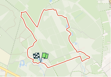
![](/images/other/stat-length.png)
![Tocht Te voet Arnhem - Warnsborn - Photo](https://media.geolcdn.com/t/1900/400/b5ce95be-17b5-43a6-a5c0-b58c49c7b2a3.jpeg&format=pjpeg&maxdim=2)
Warnsborn
SityTrail - itinéraires balisés pédestres
Tous les sentiers balisés d’Europe GUIDE+
![Lengte](/images/other/stat-length.png)
![Max. hoogte](https://static1.geolcdn.com/siteimages/upload/files/1508320355ic_sort_altitude_max_24dp.png)
![Positief hoogteverschil](https://static1.geolcdn.com/siteimages/upload/files/1508320355ic_sort_den_pos_24dp.png)
![Km-Effort](/images/other/stat-length.png)
![Min. hoogte](https://static1.geolcdn.com/siteimages/upload/files/1508320355ic_sort_altitude_min_24dp.png)
![Negatief hoogteverschil](https://static1.geolcdn.com/siteimages/upload/files/1508320355ic_sort_den_neg_24dp.png)
![Boucle](https://static1.geolcdn.com/siteimages/upload/files/16400158638029165_repeat_loop_refresh_sync_direction_icon.png)
![Te voet](https://static1.geolcdn.com/sitytour/trail-icons/100.png)
1h18
Moeilijkheid : Gemakkelijk
![Scan deze QR-code om de tocht te openen in de SityTrail-applicatie](https://capi.geolives.com/qq0zvz2zws4bq2lad0pu/sitytour/trails/3108758/qr.png?size=200)
Gratisgps-wandelapplicatie
Over ons
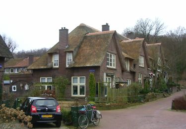
Tocht Te voet van 4,9 km beschikbaar op Gelderland, Onbekend, Arnhem. Deze tocht wordt voorgesteld door SityTrail - itinéraires balisés pédestres.
Beschrijving
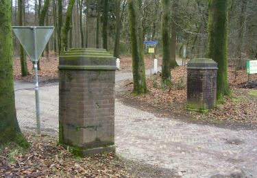
Hoog Erf bestaat uit weilanden, akkers, loofbosjes en singels. Een mooi punt is ‘de ster’. Hier komen zes lanen van het landgoed bij elkaar. Een heerl
Website: https://www.glk.nl/landschappen-kastelen/locatie/hoog-erf
Plaatsbepaling
Opmerkingen
Wandeltochten in de omgeving
![Tocht Te voet Ede - Oud Reemst - Blauw - Photo](https://media.geolcdn.com/t/375/260/7f30981a-8c7c-4f0d-ac51-6ff256539cde.jpeg&format=jpg&maxdim=2)
![Te voet Te voet](https://static1.geolcdn.com/sitytour/trail-icons/100.png)
Te voet
![](/images/other/stat-length.png)
![](https://static1.geolcdn.com/siteimages/upload/files/16400158638029165_repeat_loop_refresh_sync_direction_icon.png)
![Tocht Te voet Ede - Buunderkamp - Rode pijl - Photo](https://media.geolcdn.com/t/375/260/968a0081-d191-41d7-a424-5be7a0106691.jpeg&format=jpg&maxdim=2)
![Te voet Te voet](https://static1.geolcdn.com/sitytour/trail-icons/100.png)
Te voet
![](/images/other/stat-length.png)
![](https://static1.geolcdn.com/siteimages/upload/files/16400158638029165_repeat_loop_refresh_sync_direction_icon.png)
![Tocht Te voet Renkum - Dorenweertsepad - Photo](https://media.geolcdn.com/t/375/260/b7c380c3-a109-4b9c-9971-85e75dba5716.jpeg&format=jpg&maxdim=2)
![Te voet Te voet](https://static1.geolcdn.com/sitytour/trail-icons/100.png)
Te voet
![](/images/other/stat-length.png)
![](https://static1.geolcdn.com/siteimages/upload/files/16400158638029165_repeat_loop_refresh_sync_direction_icon.png)
![Tocht Te voet Ede - Oud Reemst - Geel - Photo](https://media.geolcdn.com/t/375/260/25466423-843d-4903-a4c1-99a07e86a578.jpeg&format=jpg&maxdim=2)
![Te voet Te voet](https://static1.geolcdn.com/sitytour/trail-icons/100.png)
Te voet
![](/images/other/stat-length.png)
![](https://static1.geolcdn.com/siteimages/upload/files/16400158638029165_repeat_loop_refresh_sync_direction_icon.png)
![Tocht Te voet Arnhem - NS-wandeling Warnsborn - Photo](https://media.geolcdn.com/t/375/260/68894f33-5963-49f9-a97e-666a755bcf4a.jpeg&format=jpg&maxdim=2)
![Te voet Te voet](https://static1.geolcdn.com/sitytour/trail-icons/100.png)
Te voet
![](/images/other/stat-length.png)
![](https://static1.geolcdn.com/siteimages/upload/files/16400158638029165_repeat_loop_refresh_sync_direction_icon.png)
![Tocht Te voet Renkum - NS-wandeling Hemelse Berg - Photo](https://media.geolcdn.com/t/375/260/93ca447f-42ea-4496-8d0a-71e3f7e5f83d.jpeg&format=jpg&maxdim=2)
![Te voet Te voet](https://static1.geolcdn.com/sitytour/trail-icons/100.png)
Te voet
![](/images/other/stat-length.png)
![](https://static1.geolcdn.com/siteimages/upload/files/16400158638029165_repeat_loop_refresh_sync_direction_icon.png)
![Tocht Te voet Arnhem - Groene Wissel: Arnhem - Photo](https://media.geolcdn.com/t/375/260/ac0c51f6-2192-4fb5-94e9-c2127ec0716b.jpeg&format=jpg&maxdim=2)
![Te voet Te voet](https://static1.geolcdn.com/sitytour/trail-icons/100.png)
Te voet
![](/images/other/stat-length.png)
![](https://static1.geolcdn.com/siteimages/upload/files/16400158638029165_repeat_loop_refresh_sync_direction_icon.png)
![Tocht Te voet Renkum - Groene Wissel: Oosterbeek 066 - Photo](https://media.geolcdn.com/t/375/260/81498446-d79c-472a-b0ce-1a39418acc87.jpeg&format=jpg&maxdim=2)
![Te voet Te voet](https://static1.geolcdn.com/sitytour/trail-icons/100.png)
Te voet
![](/images/other/stat-length.png)
![](https://static1.geolcdn.com/siteimages/upload/files/16400158638029165_repeat_loop_refresh_sync_direction_icon.png)
![Tocht Te voet Renkum - Hoog Oorsprong-Zilverberg-route - Photo](https://media.geolcdn.com/t/375/260/4702f4c7-6a19-4ca0-b9b0-1f08d41c7ac1.jpeg&format=jpg&maxdim=2)
![Te voet Te voet](https://static1.geolcdn.com/sitytour/trail-icons/100.png)
Te voet
![](/images/other/stat-length.png)
![](https://static1.geolcdn.com/siteimages/upload/files/16400158638029165_repeat_loop_refresh_sync_direction_icon.png)