![](/images/other/stat-length.png)
![Tocht Te voet Zandvoort - AWD-Zandvoortselaan-Groen - Photo](https://media.geolcdn.com/t/1900/400/c9c74e60-1e2f-40bc-bdf0-6fa686f457c5.jpeg&format=pjpeg&maxdim=2)
AWD-Zandvoortselaan-Groen
SityTrail - itinéraires balisés pédestres
Tous les sentiers balisés d’Europe GUIDE+
![Lengte](/images/other/stat-length.png)
Lengte
6,6 km
![Max. hoogte](https://static1.geolcdn.com/siteimages/upload/files/1508320355ic_sort_altitude_max_24dp.png)
Max. hoogte
23 m
![Positief hoogteverschil](https://static1.geolcdn.com/siteimages/upload/files/1508320355ic_sort_den_pos_24dp.png)
Positief hoogteverschil
43 m
![Km-Effort](/images/other/stat-length.png)
Km-Effort
7,2 km
![Min. hoogte](https://static1.geolcdn.com/siteimages/upload/files/1508320355ic_sort_altitude_min_24dp.png)
Min. hoogte
3 m
![Negatief hoogteverschil](https://static1.geolcdn.com/siteimages/upload/files/1508320355ic_sort_den_neg_24dp.png)
Negatief hoogteverschil
45 m
![Boucle](https://static1.geolcdn.com/siteimages/upload/files/16400158638029165_repeat_loop_refresh_sync_direction_icon.png)
Boucle
Neen
Markering
Datum van aanmaak :
2022-02-14 14:27:12.267
Laatste wijziging :
2022-02-14 14:27:12.267
![Te voet](https://static1.geolcdn.com/sitytour/trail-icons/100.png)
1h38
Moeilijkheid : Gemakkelijk
![Scan deze QR-code om de tocht te openen in de SityTrail-applicatie](https://capi.geolives.com/qq0zvz2zws4bq2lad0pu/sitytour/trails/3108610/qr.png?size=200)
Gratisgps-wandelapplicatie
Over ons
Tocht Te voet van 6,6 km beschikbaar op Noord-Holland, Onbekend, Zandvoort. Deze tocht wordt voorgesteld door SityTrail - itinéraires balisés pédestres.
Beschrijving
Wandelroute
Website: https://awd.waternet.nl/beleef/wandelroutes/route/#!/31-groene-route-zandvoortselaan/0
Plaatsbepaling
Land:
Netherlands
Regio :
Noord-Holland
Departement/Provincie :
Onbekend
Gemeente :
Zandvoort
Locatie:
Unknown
Vertrek:(Dec)
Vertrek:(UTM)
605765 ; 5802706 (31U) N.
Opmerkingen
Wandeltochten in de omgeving
![Tocht Te voet Bloemendaal - AWD-Pannenland-Blauw - Photo](https://media.geolcdn.com/t/375/260/995a4050-fd4f-40b8-835f-269113065990.jpeg&format=jpg&maxdim=2)
![Te voet Te voet](https://static1.geolcdn.com/sitytour/trail-icons/100.png)
AWD-Pannenland-Blauw
Te voet
Gemakkelijk
Bloemendaal,
Noord-Holland,
Onbekend,
Netherlands
![](/images/other/stat-length.png)
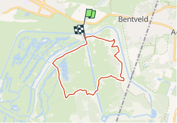
7,7 km | 8,3 km-effort
1h 52min
![](https://static1.geolcdn.com/siteimages/upload/files/16400158638029165_repeat_loop_refresh_sync_direction_icon.png)
Ja
![Tocht Te voet Bloemendaal - AWD-Oase-Oranje - Photo](https://media.geolcdn.com/t/375/260/dev_f893a746-fd46-4fd4-9a39-a671002456fc.jpeg&format=jpg&maxdim=2)
![Te voet Te voet](https://static1.geolcdn.com/sitytour/trail-icons/100.png)
AWD-Oase-Oranje
Te voet
Gemakkelijk
Bloemendaal,
Noord-Holland,
Onbekend,
Netherlands
![](/images/other/stat-length.png)
6,8 km | 7,6 km-effort
1h 44min
![](https://static1.geolcdn.com/siteimages/upload/files/16400158638029165_repeat_loop_refresh_sync_direction_icon.png)
Ja
![Tocht Te voet Bloemendaal - AWD-Pannenland-Rood - Photo](https://media.geolcdn.com/t/375/260/995a4050-fd4f-40b8-835f-269113065990.jpeg&format=jpg&maxdim=2)
![Te voet Te voet](https://static1.geolcdn.com/sitytour/trail-icons/100.png)
AWD-Pannenland-Rood
Te voet
Gemakkelijk
Bloemendaal,
Noord-Holland,
Onbekend,
Netherlands
![](/images/other/stat-length.png)
3,7 km | 4 km-effort
54min
![](https://static1.geolcdn.com/siteimages/upload/files/16400158638029165_repeat_loop_refresh_sync_direction_icon.png)
Ja
![Tocht Te voet Bloemendaal - Vinkenduin en Oud Woestduin - Photo](https://media.geolcdn.com/t/375/260/dev_484e4a31-64e0-48ec-af9a-c12e06f55af1.jpeg&format=jpg&maxdim=2)
![Te voet Te voet](https://static1.geolcdn.com/sitytour/trail-icons/100.png)
Vinkenduin en Oud Woestduin
Te voet
Gemakkelijk
Bloemendaal,
Noord-Holland,
Onbekend,
Netherlands
![](/images/other/stat-length.png)
3,3 km | 3,7 km-effort
49min
![](https://static1.geolcdn.com/siteimages/upload/files/16400158638029165_repeat_loop_refresh_sync_direction_icon.png)
Ja
![Tocht Te voet Bloemendaal - AWD-Oase-Geel - Photo](https://media.geolcdn.com/t/375/260/dev_484e4a31-64e0-48ec-af9a-c12e06f55af1.jpeg&format=jpg&maxdim=2)
![Te voet Te voet](https://static1.geolcdn.com/sitytour/trail-icons/100.png)
AWD-Oase-Geel
Te voet
Gemakkelijk
Bloemendaal,
Noord-Holland,
Onbekend,
Netherlands
![](/images/other/stat-length.png)
3,2 km | 3,8 km-effort
51min
![](https://static1.geolcdn.com/siteimages/upload/files/16400158638029165_repeat_loop_refresh_sync_direction_icon.png)
Neen
![Tocht Te voet Bloemendaal - Groene route - Photo](https://media.geolcdn.com/t/375/260/c39dbb0d-a332-4384-9ee6-6874865ed113.jpeg&format=jpg&maxdim=2)
![Te voet Te voet](https://static1.geolcdn.com/sitytour/trail-icons/100.png)
Groene route
Te voet
Gemakkelijk
Bloemendaal,
Noord-Holland,
Onbekend,
Netherlands
![](/images/other/stat-length.png)
3,6 km | 4,2 km-effort
56min
![](https://static1.geolcdn.com/siteimages/upload/files/16400158638029165_repeat_loop_refresh_sync_direction_icon.png)
Ja
![Tocht Te voet Bloemendaal - Middenduin Rood - Photo](https://media.geolcdn.com/t/375/260/04572f8f-8672-4978-a32e-b34259a507a1.jpeg&format=jpg&maxdim=2)
![Te voet Te voet](https://static1.geolcdn.com/sitytour/trail-icons/100.png)
Middenduin Rood
Te voet
Gemakkelijk
Bloemendaal,
Noord-Holland,
Onbekend,
Netherlands
![](/images/other/stat-length.png)
4 km | 4,7 km-effort
1h 4min
![](https://static1.geolcdn.com/siteimages/upload/files/16400158638029165_repeat_loop_refresh_sync_direction_icon.png)
Ja
![Tocht Te voet Bloemendaal - Middenduin-Kamperberg - Photo](https://media.geolcdn.com/t/375/260/04572f8f-8672-4978-a32e-b34259a507a1.jpeg&format=jpg&maxdim=2)
![Te voet Te voet](https://static1.geolcdn.com/sitytour/trail-icons/100.png)
Middenduin-Kamperberg
Te voet
Gemakkelijk
Bloemendaal,
Noord-Holland,
Onbekend,
Netherlands
![](/images/other/stat-length.png)
3,7 km | 4,3 km-effort
58min
![](https://static1.geolcdn.com/siteimages/upload/files/16400158638029165_repeat_loop_refresh_sync_direction_icon.png)
Ja
![Tocht Te voet Zandvoort - gele route - Photo](https://media.geolcdn.com/t/375/260/ce050da5-4569-4bc7-beb3-f828d4910d8b.jpeg&format=jpg&maxdim=2)
![Te voet Te voet](https://static1.geolcdn.com/sitytour/trail-icons/100.png)
gele route
Te voet
Gemakkelijk
Zandvoort,
Noord-Holland,
Onbekend,
Netherlands
![](/images/other/stat-length.png)
4,7 km | 5,1 km-effort
1h 9min
![](https://static1.geolcdn.com/siteimages/upload/files/16400158638029165_repeat_loop_refresh_sync_direction_icon.png)
Neen