Tocht Te voet Calvià - ES-02 SE - Photo

Tous les sentiers balisés d’Europe GUIDE+

© OpenStreetMap contributors
Lengte
Lengte
5,8 km
Max. hoogte
Max. hoogte
481 m
Positief hoogteverschil
167 m
Km-Effort
Km-Effort  
8 km
Min. hoogte
Min. hoogte
377 m
Negatief hoogteverschil
166 m
Boucle
Boucle
Neen
Markering
Markering
Datum van aanmaak :
2022-02-14 14:24:04.343
Laatste wijziging :
2022-02-14 14:24:04.343

(0 Bericht)

Te voet
Te voet
1h49
Moeilijkheid : Gemakkelijk

Scan deze QR-code om de tocht te openen in de SityTrail-applicatie

Gratisgps-wandelapplicatie

Logo SityTrail SityTrail

IGN / Geografische instituten

SityTrail uit de App Store downloaden SityTrail uit Google Play downloaden

Logo SityTrail SityTrail World

De wereld gaat voor u open

SityTrail uit de App Store downloaden SityTrail uit Google Play downloaden SityTrail op Huawei AppGallery downloaden

Over ons

Tocht Te voet van 5,8 km beschikbaar op Balearen, Onbekend, Calvià. Deze tocht wordt voorgesteld door SityTrail - itinéraires balisés pédestres.

Beschrijving

This has not official name and no official route. The name:de and ref of route are from the book appear in source:name

Hoogteprofiel

Foto's

Plaatsbepaling

Land:
Spain
Regio :
Balearen
Departement/Provincie :
Onbekend
Gemeente :
Calvià
Locatie:
Unknown
Vertrek:(UTM)
462519 ; 4381449 (31S) N.

Wandeltochten in de omgeving

Tocht Te voet Puigpunyent - Son Font - Bauca - Galilea - Son Font - Photo
Te voet
GUIDE+

Te voet

Gemakkelijk
Puigpunyent, Balearen, Onbekend, Spain
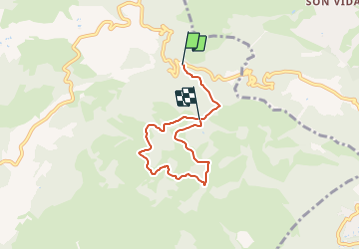
3 km | 3,8 km-effort
51min
Neen
Tocht Stappen Calvià - Serra de Na Burguesa 7-10-2017 - Photo
Stappen
GUIDE
fredetpascale

Stappen

Gemakkelijk
Calvià, Balearen, Onbekend, Spain
15,5 km | 21 km-effort
3h 43min
Ja
Tocht Fiets  - palma-port d'andratx - Photo
Fiets
massou34

Fiets

Medium
, Balearen, , Spain
62 km | 77 km-effort
4h 22min
Ja


Sluiten
Mijn abonnementen