![](/images/other/stat-length.png)
![Tocht Te voet Airolo - Strada Alta - Photo](https://media.geolcdn.com/t/1900/400/a11c2b9a-53fe-4f2a-84f2-135767ac283d.jpeg&format=pjpeg&maxdim=2)
Strada Alta
SityTrail - itinéraires balisés pédestres
Tous les sentiers balisés d’Europe GUIDE+
![Lengte](/images/other/stat-length.png)
Lengte
44 km
![Max. hoogte](https://static1.geolcdn.com/siteimages/upload/files/1508320355ic_sort_altitude_max_24dp.png)
Max. hoogte
1443 m
![Positief hoogteverschil](https://static1.geolcdn.com/siteimages/upload/files/1508320355ic_sort_den_pos_24dp.png)
Positief hoogteverschil
1519 m
![Km-Effort](/images/other/stat-length.png)
Km-Effort
67 km
![Min. hoogte](https://static1.geolcdn.com/siteimages/upload/files/1508320355ic_sort_altitude_min_24dp.png)
Min. hoogte
299 m
![Negatief hoogteverschil](https://static1.geolcdn.com/siteimages/upload/files/1508320355ic_sort_den_neg_24dp.png)
Negatief hoogteverschil
2360 m
![Boucle](https://static1.geolcdn.com/siteimages/upload/files/16400158638029165_repeat_loop_refresh_sync_direction_icon.png)
Boucle
Neen
Markering
Datum van aanmaak :
2022-02-14 08:45:26.943
Laatste wijziging :
2022-02-14 08:45:26.943
![Te voet](https://static1.geolcdn.com/sitytour/trail-icons/100.png)
15h17
Moeilijkheid : Zeer moeilijk
![Scan deze QR-code om de tocht te openen in de SityTrail-applicatie](https://capi.geolives.com/qq0zvz2zws4bq2lad0pu/sitytour/trails/3105887/qr.png?size=200)
Gratisgps-wandelapplicatie
Over ons
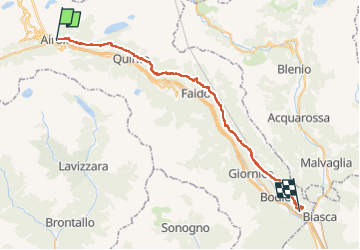
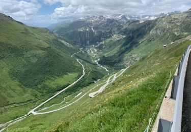
Tocht Te voet van 44 km beschikbaar op Ticino, Distretto di Leventina, Airolo. Deze tocht wordt voorgesteld door SityTrail - itinéraires balisés pédestres.
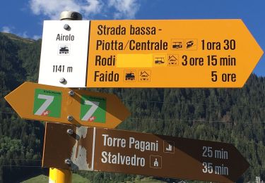
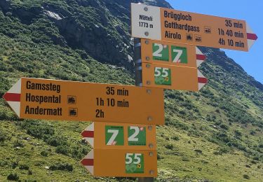
Beschrijving
Airolo-Pollegio
Symbol: weiss-rot-weiss
Website: http://www.stradaalta.ch
Plaatsbepaling
Land:
Switzerland
Regio :
Ticino
Departement/Provincie :
Distretto di Leventina
Gemeente :
Airolo
Locatie:
Unknown
Vertrek:(Dec)
Vertrek:(UTM)
470001 ; 5152759 (32T) N.
Opmerkingen
Wandeltochten in de omgeving
![Tocht Te voet Airolo - Strada Bassa - Photo](https://media.geolcdn.com/t/375/260/f81afdc9-f182-46ad-8198-37dc98335834.jpeg&format=jpg&maxdim=2)
![Te voet Te voet](https://static1.geolcdn.com/sitytour/trail-icons/100.png)
Strada Bassa
Te voet
Medium
Airolo,
Ticino,
Distretto di Leventina,
Switzerland
![](/images/other/stat-length.png)
19,2 km | 27 km-effort
6h 3min
![](https://static1.geolcdn.com/siteimages/upload/files/16400158638029165_repeat_loop_refresh_sync_direction_icon.png)
Neen
![Tocht Te voet Airolo - Strada degli Alpi - Photo](https://media.geolcdn.com/t/375/260/28d1a178-b79f-4e14-a216-ad8ff4ed8b5f.jpeg&format=jpg&maxdim=2)
![Te voet Te voet](https://static1.geolcdn.com/sitytour/trail-icons/100.png)
Strada degli Alpi
Te voet
Gemakkelijk
Airolo,
Ticino,
Distretto di Leventina,
Switzerland
![](/images/other/stat-length.png)
13,2 km | 19,8 km-effort
4h 30min
![](https://static1.geolcdn.com/siteimages/upload/files/16400158638029165_repeat_loop_refresh_sync_direction_icon.png)
Neen
![Tocht Te voet Airolo - Val Canaria-Airolo - Photo](https://media.geolcdn.com/t/375/260/3c8cce33-76eb-4790-8142-9295e7104542.jpeg&format=jpg&maxdim=2)
![Te voet Te voet](https://static1.geolcdn.com/sitytour/trail-icons/100.png)
Val Canaria-Airolo
Te voet
Gemakkelijk
Airolo,
Ticino,
Distretto di Leventina,
Switzerland
![](/images/other/stat-length.png)
5,3 km | 7,8 km-effort
1h 46min
![](https://static1.geolcdn.com/siteimages/upload/files/16400158638029165_repeat_loop_refresh_sync_direction_icon.png)
Neen
![Tocht Te voet Airolo - Ospizio San Gottardo-Hospental - Photo](https://media.geolcdn.com/t/375/260/7913350d-e445-44c6-bc03-c3845fc867df.jpeg&format=jpg&maxdim=2)
![Te voet Te voet](https://static1.geolcdn.com/sitytour/trail-icons/100.png)
Ospizio San Gottardo-Hospental
Te voet
Gemakkelijk
Airolo,
Ticino,
Distretto di Leventina,
Switzerland
![](/images/other/stat-length.png)
9,1 km | 11,6 km-effort
2h 38min
![](https://static1.geolcdn.com/siteimages/upload/files/16400158638029165_repeat_loop_refresh_sync_direction_icon.png)
Neen
![Tocht Te voet Airolo - Lago della Sella - fixme - Photo](https://media.geolcdn.com/t/375/260/bac52592-0270-43aa-838e-a06b26324961.jpeg&format=jpg&maxdim=2)
![Te voet Te voet](https://static1.geolcdn.com/sitytour/trail-icons/100.png)
Lago della Sella - fixme
Te voet
Gemakkelijk
Airolo,
Ticino,
Distretto di Leventina,
Switzerland
![](/images/other/stat-length.png)
3 km | 5,4 km-effort
1h 13min
![](https://static1.geolcdn.com/siteimages/upload/files/16400158638029165_repeat_loop_refresh_sync_direction_icon.png)
Neen
![Tocht Wegfiets Airolo - Airolo 3 cols - Photo](https://media.geolcdn.com/t/375/260/c7e30b72-19e3-4b6a-9b61-119f8d0a22db.jpeg&format=jpg&maxdim=2)
![Wegfiets Wegfiets](https://static1.geolcdn.com/sitytour/trail-icons/201.png)
Airolo 3 cols
Wegfiets
Zeer moeilijk
Airolo,
Ticino,
Distretto di Leventina,
Switzerland
![](/images/other/stat-length.png)
100 km | 144 km-effort
8h 43min
![](https://static1.geolcdn.com/siteimages/upload/files/16400158638029165_repeat_loop_refresh_sync_direction_icon.png)
Ja
![Tocht Wegfiets Airolo - Airolo barrage Ambri - Photo](https://media.geolcdn.com/t/375/260/9a5712b3-59c7-4bf7-903a-892ab1fd81eb.heic&format=jpg&maxdim=2)
![Wegfiets Wegfiets](https://static1.geolcdn.com/sitytour/trail-icons/201.png)
Airolo barrage Ambri
Wegfiets
Zeer moeilijk
Airolo,
Ticino,
Distretto di Leventina,
Switzerland
![](/images/other/stat-length.png)
28 km | 43 km-effort
2h 35min
![](https://static1.geolcdn.com/siteimages/upload/files/16400158638029165_repeat_loop_refresh_sync_direction_icon.png)
Ja
![Tocht Te voet Airolo - Sopra Valle-Buco di Ce - Photo](https://media.geolcdn.com/t/375/260/ext.jpg?maxdim=2&url=https%3A%2F%2Fstatic1.geolcdn.com%2Fsiteimages%2Fupload%2Ffiles%2F1545311037marcheuse_200dpi.jpg)
![Te voet Te voet](https://static1.geolcdn.com/sitytour/trail-icons/100.png)
Sopra Valle-Buco di Ce
Te voet
Gemakkelijk
Airolo,
Ticino,
Distretto di Leventina,
Switzerland
![](/images/other/stat-length.png)
3,2 km | 6,2 km-effort
1h 24min
![](https://static1.geolcdn.com/siteimages/upload/files/16400158638029165_repeat_loop_refresh_sync_direction_icon.png)
Neen
![Tocht Te voet Airolo - Motto Bartola-Ospizio San Gottardo - Photo](https://media.geolcdn.com/t/375/260/ext.jpg?maxdim=2&url=https%3A%2F%2Fstatic1.geolcdn.com%2Fsiteimages%2Fupload%2Ffiles%2F1545311037marcheuse_200dpi.jpg)
![Te voet Te voet](https://static1.geolcdn.com/sitytour/trail-icons/100.png)
Motto Bartola-Ospizio San Gottardo
Te voet
Gemakkelijk
Airolo,
Ticino,
Distretto di Leventina,
Switzerland
![](/images/other/stat-length.png)
4,6 km | 6,6 km-effort
1h 29min
![](https://static1.geolcdn.com/siteimages/upload/files/16400158638029165_repeat_loop_refresh_sync_direction_icon.png)
Neen