Tocht Stappen Antibes - Grand tour du cap d'Antibes 13-02-2022 - Photo

Grand tour du cap d'Antibes 13-02-2022

 fredetpascale
fredetpascale

Gebruiker GUIDE

© OpenStreetMap contributors
Lengte
Lengte
16,5 km
Max. hoogte
Max. hoogte
79 m
Positief hoogteverschil
233 m
Km-Effort
Km-Effort  
19,6 km
Min. hoogte
Min. hoogte
0 m
Negatief hoogteverschil
238 m
Boucle
Boucle
Ja
Datum van aanmaak :
2022-02-13 08:12:50.101
Laatste wijziging :
2022-02-13 16:52:14.86

(0 Bericht)

Stappen
Stappen
4h30
Moeilijkheid : Medium

Scan deze QR-code om de tocht te openen in de SityTrail-applicatie

Gratisgps-wandelapplicatie

Logo SityTrail SityTrail

IGN / Geografische instituten

SityTrail uit de App Store downloaden SityTrail uit Google Play downloaden

Logo SityTrail SityTrail World

De wereld gaat voor u open

SityTrail uit de App Store downloaden SityTrail uit Google Play downloaden SityTrail op Huawei AppGallery downloaden

Over ons

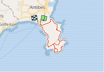
Tocht Stappen van 16,5 km beschikbaar op Provence-Alpes-Côte d'Azur, Alpes-Maritimes, Antibes. Deze tocht wordt voorgesteld door fredetpascale.

Beschrijving

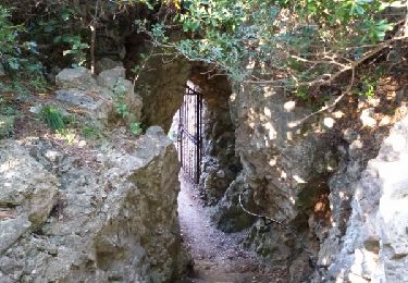
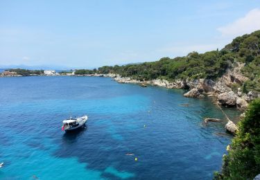
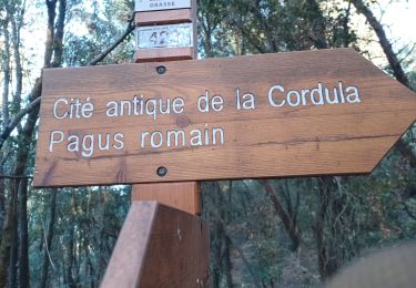
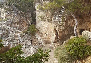
Une grille ferme le sentier du littoral au niveau du Cap Gros et après sentier ouvert !

Hoogteprofiel

Plaatsbepaling

Land:
France
Regio :
Provence-Alpes-Côte d'Azur
Departement/Provincie :
Alpes-Maritimes
Gemeente :
Antibes
Locatie:
Unknown
Vertrek:(UTM)
347572 ; 4825680 (32T) N.

Wandeltochten in de omgeving

Tocht Stappen Antibes - Circuit de L'anse de faux d'argent 2r-10-14 - Photo
Stappen
Dervalmarc

Stappen

Heel gemakkelijk
(2)
Antibes, Provence-Alpes-Côte d'Azur, Alpes-Maritimes, France
2,3 km | 2,8 km-effort
54min
Ja
Tocht Te voet Antibes - Tour du Cap d'Antibes - Photo
Te voet
GUIDE+

Te voet

Gemakkelijk
Antibes, Provence-Alpes-Côte d'Azur, Alpes-Maritimes, France
4,6 km | 5,3 km-effort
1h 12min
Ja
Tocht Te voet Valbonne - Circuit de l'Aqueduc - Photo
Te voet
GUIDE+

Te voet

Gemakkelijk
Valbonne, Provence-Alpes-Côte d'Azur, Alpes-Maritimes, France
6,3 km | 8 km-effort
1h 49min
Ja
Tocht Stappen Antibes - Cap d'Antibes - Photo
Stappen
GUIDE
Orcal37

Stappen

Gemakkelijk
Antibes, Provence-Alpes-Côte d'Azur, Alpes-Maritimes, France
7,6 km | 8,8 km-effort
2h 20min
Ja
Tocht Stappen Antibes - z le cap d'Antibes 29-09-20 - Photo
Stappen
cb8310

Stappen

Heel gemakkelijk
Antibes, Provence-Alpes-Côte d'Azur, Alpes-Maritimes, France
4,7 km | 5,4 km-effort
1h 58min
Ja
Tocht Stappen Antibes - cap d'antibes - Photo
Stappen
poisson1103

Stappen

Heel gemakkelijk
(1)
Antibes, Provence-Alpes-Côte d'Azur, Alpes-Maritimes, France
5,2 km | 6,1 km-effort
2h 20min
Ja
Tocht Stappen Antibes - Tour du Cap d'Antibes - Photo
Stappen
GUIDE
toutankhcarton

Stappen

Heel gemakkelijk
(1)
Antibes, Provence-Alpes-Côte d'Azur, Alpes-Maritimes, France
5,2 km | 6 km-effort
2h 3min
Ja
Tocht Stappen Vallauris - Golfe-Juan Antibes gare à gare - Photo
Stappen
pjjrevrard

Stappen

Gemakkelijk
(1)
Vallauris, Provence-Alpes-Côte d'Azur, Alpes-Maritimes, France
10,2 km | 12,2 km-effort
2h 32min
Neen
Tocht Stappen Vallauris - VALLAURIS . CITE ANTIQUE DE LA CORDULA O - Photo
Stappen
RobinMicheline

Stappen

Medium
Vallauris, Provence-Alpes-Côte d'Azur, Alpes-Maritimes, France
5,9 km | 7,7 km-effort
1h 50min
Ja


Sluiten
Mijn abonnementen