![](/images/other/stat-length.png)
![Tocht Stappen Chalon-sur-Saône - Chalon Port Guillot Lux sentier de la Thalie Chalon - Photo](https://media.geolcdn.com/t/1900/400/afd7d2e3-221b-46d6-a2d7-5a57ba1a946c.jpg&format=pjpeg&maxdim=2)
Chalon Port Guillot Lux sentier de la Thalie Chalon
pensionisten71
Gebruiker
![Lengte](/images/other/stat-length.png)
Lengte
9,7 km
![Max. hoogte](https://static1.geolcdn.com/siteimages/upload/files/1508320355ic_sort_altitude_max_24dp.png)
Max. hoogte
189 m
![Positief hoogteverschil](https://static1.geolcdn.com/siteimages/upload/files/1508320355ic_sort_den_pos_24dp.png)
Positief hoogteverschil
72 m
![Km-Effort](/images/other/stat-length.png)
Km-Effort
10,7 km
![Min. hoogte](https://static1.geolcdn.com/siteimages/upload/files/1508320355ic_sort_altitude_min_24dp.png)
Min. hoogte
169 m
![Negatief hoogteverschil](https://static1.geolcdn.com/siteimages/upload/files/1508320355ic_sort_den_neg_24dp.png)
Negatief hoogteverschil
72 m
![Boucle](https://static1.geolcdn.com/siteimages/upload/files/16400158638029165_repeat_loop_refresh_sync_direction_icon.png)
Boucle
Ja
Datum van aanmaak :
2022-02-13 13:58:19.868
Laatste wijziging :
2022-02-13 15:57:35.49
![Stappen](https://static1.geolcdn.com/sitytour/trail-icons/101.png)
1h57
Moeilijkheid : Gemakkelijk
![Scan deze QR-code om de tocht te openen in de SityTrail-applicatie](https://capi.geolives.com/qq0zvz2zws4bq2lad0pu/sitytour/trails/3105021/qr.png?size=200)
Gratisgps-wandelapplicatie
Over ons
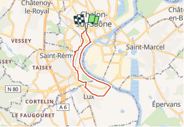
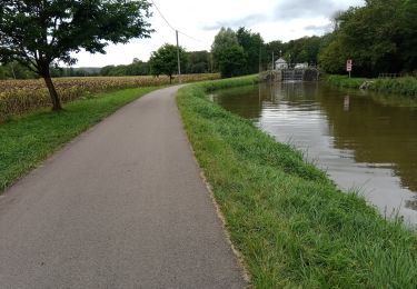
Tocht Stappen van 9,7 km beschikbaar op Bourgondië-Franche-Comté, Saône-et-Loire, Chalon-sur-Saône. Deze tocht wordt voorgesteld door pensionisten71.
Beschrijving
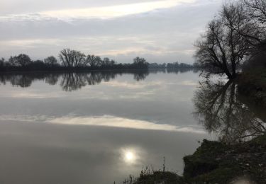
balade chemin qui suit la Saône
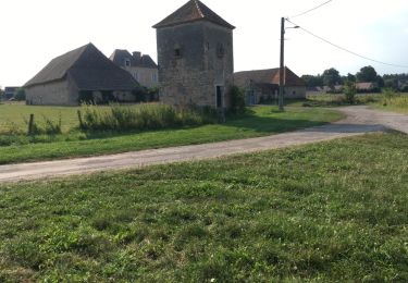
puis passage dans Lux et retour par le chemin de la Thalie.
Plaatsbepaling
Land:
France
Regio :
Bourgondië-Franche-Comté
Departement/Provincie :
Saône-et-Loire
Gemeente :
Chalon-sur-Saône
Locatie:
Unknown
Vertrek:(Dec)
Vertrek:(UTM)
641069 ; 5182753 (31T) N.
Opmerkingen
Wandeltochten in de omgeving
![Tocht Stappen Chalon-sur-Saône - Balade en bord de Saône à Chalon - Photo](https://media.geolcdn.com/t/375/260/8e4d7cac-cf9f-46b7-a64e-342de3a9e9d5.jpg&format=jpg&maxdim=2)
![Stappen Stappen](https://static1.geolcdn.com/sitytour/trail-icons/101.png)
Balade en bord de Saône à Chalon
Stappen
Gemakkelijk
Chalon-sur-Saône,
Bourgondië-Franche-Comté,
Saône-et-Loire,
France
![](/images/other/stat-length.png)
5,6 km | 6,4 km-effort
1h 15min
![](https://static1.geolcdn.com/siteimages/upload/files/16400158638029165_repeat_loop_refresh_sync_direction_icon.png)
Ja
![Tocht Stappen Chalon-sur-Saône - Chalon embouchure de la Thalie et retour - Photo](https://media.geolcdn.com/t/375/260/abde2e03-69c5-4324-8dc4-e3b5352ebee9.jpg&format=jpg&maxdim=2)
![Stappen Stappen](https://static1.geolcdn.com/sitytour/trail-icons/101.png)
Chalon embouchure de la Thalie et retour
Stappen
Gemakkelijk
Chalon-sur-Saône,
Bourgondië-Franche-Comté,
Saône-et-Loire,
France
![](/images/other/stat-length.png)
7,3 km | 7,8 km-effort
1h 31min
![](https://static1.geolcdn.com/siteimages/upload/files/16400158638029165_repeat_loop_refresh_sync_direction_icon.png)
Ja
![Tocht Mountainbike Chalon-sur-Saône - rando chaumes de givry av christppher - Photo](https://media.geolcdn.com/t/375/260/ext.jpg?maxdim=2&url=https%3A%2F%2Fservices.sitytrail.com%2FGeolivesWS%2FDownloadMedia.ashx%3FTrailID%3D411059%26Media%3Dfix__20150422163330.jpg)
![Mountainbike Mountainbike](https://static1.geolcdn.com/sitytour/trail-icons/202.png)
rando chaumes de givry av christppher
Mountainbike
Medium
(1)
Chalon-sur-Saône,
Bourgondië-Franche-Comté,
Saône-et-Loire,
France
![](/images/other/stat-length.png)
31 km | 38 km-effort
2h 59min
![](https://static1.geolcdn.com/siteimages/upload/files/16400158638029165_repeat_loop_refresh_sync_direction_icon.png)
Ja
![Tocht Stappen Châtenoy-en-Bresse - Golf - Photo](https://media.geolcdn.com/t/375/260/f985e983-4aef-42ee-97c2-69036080e552.jpg&format=jpg&maxdim=2)
![Stappen Stappen](https://static1.geolcdn.com/sitytour/trail-icons/101.png)
Golf
Stappen
Zeer moeilijk
Châtenoy-en-Bresse,
Bourgondië-Franche-Comté,
Saône-et-Loire,
France
![](/images/other/stat-length.png)
19,4 km | 21 km-effort
5h 1min
![](https://static1.geolcdn.com/siteimages/upload/files/16400158638029165_repeat_loop_refresh_sync_direction_icon.png)
Neen
![Tocht Wegfiets Saint-Marcel - mn06 - Photo](https://media.geolcdn.com/t/375/260/fa82a4c7-abc9-457c-8d2a-f07b6220f52b.jpg&format=jpg&maxdim=2)
![Wegfiets Wegfiets](https://static1.geolcdn.com/sitytour/trail-icons/201.png)
mn06
Wegfiets
Medium
Saint-Marcel,
Bourgondië-Franche-Comté,
Saône-et-Loire,
France
![](/images/other/stat-length.png)
24 km | 26 km-effort
2h 21min
![](https://static1.geolcdn.com/siteimages/upload/files/16400158638029165_repeat_loop_refresh_sync_direction_icon.png)
Neen
![Tocht Stappen Châtenoy-en-Bresse - 20190524 Parcours 9 trous Roseraie - Photo](https://media.geolcdn.com/t/375/260/099e47d3-74ed-4590-803c-7ceac8722efa.jpg&format=jpg&maxdim=2)
![Stappen Stappen](https://static1.geolcdn.com/sitytour/trail-icons/101.png)
20190524 Parcours 9 trous Roseraie
Stappen
Heel gemakkelijk
Châtenoy-en-Bresse,
Bourgondië-Franche-Comté,
Saône-et-Loire,
France
![](/images/other/stat-length.png)
5 km | 5,4 km-effort
2h 47min
![](https://static1.geolcdn.com/siteimages/upload/files/16400158638029165_repeat_loop_refresh_sync_direction_icon.png)
Ja
![Tocht Fiets Lux - LUX LA SAÔNE - Photo](https://media.geolcdn.com/t/375/260/ext.jpg?maxdim=2&url=https%3A%2F%2Fservices.sitytrail.com%2FGeolivesWS%2FDownloadMedia.ashx%3FTrailID%3D1016166%26Media%3D20180804181051.jpg)
![Fiets Fiets](https://static1.geolcdn.com/sitytour/trail-icons/200.png)
LUX LA SAÔNE
Fiets
Heel gemakkelijk
Lux,
Bourgondië-Franche-Comté,
Saône-et-Loire,
France
![](/images/other/stat-length.png)
7,7 km | 8,4 km-effort
1h 52min
![](https://static1.geolcdn.com/siteimages/upload/files/16400158638029165_repeat_loop_refresh_sync_direction_icon.png)
Ja
![Tocht Stappen Lux - Lux : la Saône - Photo](https://media.geolcdn.com/t/375/260/ext.jpg?maxdim=2&url=https%3A%2F%2Fservices.sitytrail.com%2FGeolivesWS%2FDownloadMedia.ashx%3FTrailID%3D664565%26Media%3D20161126115515.jpg)
![Stappen Stappen](https://static1.geolcdn.com/sitytour/trail-icons/101.png)
Lux : la Saône
Stappen
Heel gemakkelijk
Lux,
Bourgondië-Franche-Comté,
Saône-et-Loire,
France
![](/images/other/stat-length.png)
9,2 km | 10 km-effort
2h 14min
![](https://static1.geolcdn.com/siteimages/upload/files/16400158638029165_repeat_loop_refresh_sync_direction_icon.png)
Ja
![Tocht Te voet Saint-Marcel - St Marcel , tour des Orlans , les Savettes , retour par le bourg , le cimetière - Photo](https://media.geolcdn.com/t/375/260/ext.jpg?maxdim=2&url=https%3A%2F%2Fstatic1.geolcdn.com%2Fsiteimages%2Fupload%2Ffiles%2F1545311037marcheuse_200dpi.jpg)
![Te voet Te voet](https://static1.geolcdn.com/sitytour/trail-icons/100.png)
St Marcel , tour des Orlans , les Savettes , retour par le bourg , le cimetière
Te voet
Gemakkelijk
Saint-Marcel,
Bourgondië-Franche-Comté,
Saône-et-Loire,
France
![](/images/other/stat-length.png)
5,8 km | 6,2 km-effort
1h 25min
![](https://static1.geolcdn.com/siteimages/upload/files/16400158638029165_repeat_loop_refresh_sync_direction_icon.png)
Ja