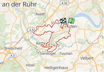
![](/images/other/stat-length.png)
![Tocht Te voet Onbekend - Kettwiger Panoramasteig - Photo](https://media.geolcdn.com/t/1900/400/c4c1ff8e-1ed2-4bc5-830a-9183bb44de95.jpeg&format=pjpeg&maxdim=2)
Kettwiger Panoramasteig
SityTrail - itinéraires balisés pédestres
Tous les sentiers balisés d’Europe GUIDE+
![Lengte](/images/other/stat-length.png)
![Max. hoogte](https://static1.geolcdn.com/siteimages/upload/files/1508320355ic_sort_altitude_max_24dp.png)
![Positief hoogteverschil](https://static1.geolcdn.com/siteimages/upload/files/1508320355ic_sort_den_pos_24dp.png)
![Km-Effort](/images/other/stat-length.png)
![Min. hoogte](https://static1.geolcdn.com/siteimages/upload/files/1508320355ic_sort_altitude_min_24dp.png)
![Negatief hoogteverschil](https://static1.geolcdn.com/siteimages/upload/files/1508320355ic_sort_den_neg_24dp.png)
![Boucle](https://static1.geolcdn.com/siteimages/upload/files/16400158638029165_repeat_loop_refresh_sync_direction_icon.png)
![Te voet](https://static1.geolcdn.com/sitytour/trail-icons/100.png)
10h07
Moeilijkheid : Zeer moeilijk
![Scan deze QR-code om de tocht te openen in de SityTrail-applicatie](https://capi.geolives.com/qq0zvz2zws4bq2lad0pu/sitytour/trails/3102180/qr.png?size=200)
Gratisgps-wandelapplicatie
Over ons
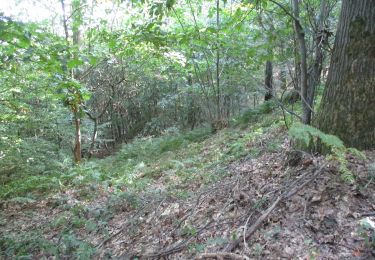
Tocht Te voet van 34 km beschikbaar op Noordrijn-Westfalen, Essen, Onbekend. Deze tocht wordt voorgesteld door SityTrail - itinéraires balisés pédestres.
Beschrijving
Trail created by Stadt Essen.
Symbol: Rote Zickzack Linie, darunter blaue Linie, darunter der Name: Kettwiger Panoramasteig auf weißem Untergrund
Website: https://www.visitessen.de/essentourismus_tourismusinformation/kettwiger_panoramasteig.de.html
Plaatsbepaling
Opmerkingen
Wandeltochten in de omgeving
![Tocht Te voet Onbekend - Pilgerweg Heidhausen - Essen - Photo](https://media.geolcdn.com/t/375/260/982c6e32-3d1c-4d42-a67d-562ea32f65b9.jpeg&format=jpg&maxdim=2)
![Te voet Te voet](https://static1.geolcdn.com/sitytour/trail-icons/100.png)
Te voet
![](/images/other/stat-length.png)
![](https://static1.geolcdn.com/siteimages/upload/files/16400158638029165_repeat_loop_refresh_sync_direction_icon.png)
![Tocht Te voet Onbekend - BaldeneySteig - Photo](https://media.geolcdn.com/t/375/260/6b304d79-4029-4f4c-bae2-94841998b36b.jpeg&format=jpg&maxdim=2)
![Te voet Te voet](https://static1.geolcdn.com/sitytour/trail-icons/100.png)
Te voet
![](/images/other/stat-length.png)
![](https://static1.geolcdn.com/siteimages/upload/files/16400158638029165_repeat_loop_refresh_sync_direction_icon.png)
![Tocht Te voet Onbekend - Isenbügel Rundweg A2 - Photo](https://media.geolcdn.com/t/375/260/58b23ba0-f4be-49fb-b2e8-8f0d898b9043.jpeg&format=jpg&maxdim=2)
![Te voet Te voet](https://static1.geolcdn.com/sitytour/trail-icons/100.png)
Te voet
![](/images/other/stat-length.png)
![](https://static1.geolcdn.com/siteimages/upload/files/16400158638029165_repeat_loop_refresh_sync_direction_icon.png)
![Tocht Te voet Onbekend - Naturfreundeweg Ruhrtalhaus - Kettwig - Tönisheide - Photo](https://media.geolcdn.com/t/375/260/882e315b-2a5a-42a9-8c87-cfa647c78e94.jpeg&format=jpg&maxdim=2)
![Te voet Te voet](https://static1.geolcdn.com/sitytour/trail-icons/100.png)
Te voet
![](/images/other/stat-length.png)
![](https://static1.geolcdn.com/siteimages/upload/files/16400158638029165_repeat_loop_refresh_sync_direction_icon.png)
![Tocht Te voet Heiligenhaus - Abtsküche Rundweg A5 - Photo](https://media.geolcdn.com/t/375/260/e6e68dcd-8ca6-4040-9101-ed67c7d0931d.jpeg&format=jpg&maxdim=2)
![Te voet Te voet](https://static1.geolcdn.com/sitytour/trail-icons/100.png)
Te voet
![](/images/other/stat-length.png)
![](https://static1.geolcdn.com/siteimages/upload/files/16400158638029165_repeat_loop_refresh_sync_direction_icon.png)
![Tocht Te voet Onbekend - Langenhorst Rundweg A2 - Photo](https://media.geolcdn.com/t/375/260/37de7098-65d5-4f9b-8826-39875ca85d50.jpeg&format=jpg&maxdim=2)
![Te voet Te voet](https://static1.geolcdn.com/sitytour/trail-icons/100.png)
Te voet
![](/images/other/stat-length.png)
![](https://static1.geolcdn.com/siteimages/upload/files/16400158638029165_repeat_loop_refresh_sync_direction_icon.png)
![Tocht Te voet Velbert - Langenhorst Rundweg A1 - Photo](https://media.geolcdn.com/t/375/260/7ff53489-f316-46ed-b660-427b68b3933c.jpeg&format=jpg&maxdim=2)
![Te voet Te voet](https://static1.geolcdn.com/sitytour/trail-icons/100.png)
Te voet
![](/images/other/stat-length.png)
![](https://static1.geolcdn.com/siteimages/upload/files/16400158638029165_repeat_loop_refresh_sync_direction_icon.png)
![Tocht Te voet Onbekend - Naturfreundeweg Ruhrtalhaus - Werden - Tönisheide - Photo](https://media.geolcdn.com/t/375/260/8893a24b-e061-4946-8526-b0b57bfb0c41.jpeg&format=jpg&maxdim=2)
![Te voet Te voet](https://static1.geolcdn.com/sitytour/trail-icons/100.png)
Te voet
![](/images/other/stat-length.png)
![](https://static1.geolcdn.com/siteimages/upload/files/16400158638029165_repeat_loop_refresh_sync_direction_icon.png)
![Tocht Te voet Onbekend - Rundwanderweg Heissiwald A2 - Photo](https://media.geolcdn.com/t/375/260/c6a2cb87-ea19-42a9-923c-74ebad52d330.jpeg&format=jpg&maxdim=2)
![Te voet Te voet](https://static1.geolcdn.com/sitytour/trail-icons/100.png)
Te voet
![](/images/other/stat-length.png)
![](https://static1.geolcdn.com/siteimages/upload/files/16400158638029165_repeat_loop_refresh_sync_direction_icon.png)