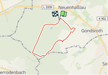
![](/images/other/stat-length.png)
![Tocht Te voet Hasselroth - Spessartspuren - Neuenhaßlauer Ysenburg-Runde - Photo](https://media.geolcdn.com/t/1900/400/2c041be9-e260-4358-b852-b0670ff23424.jpeg&format=pjpeg&maxdim=2)
Spessartspuren - Neuenhaßlauer Ysenburg-Runde
SityTrail - itinéraires balisés pédestres
Tous les sentiers balisés d’Europe GUIDE+
![Lengte](/images/other/stat-length.png)
![Max. hoogte](https://static1.geolcdn.com/siteimages/upload/files/1508320355ic_sort_altitude_max_24dp.png)
![Positief hoogteverschil](https://static1.geolcdn.com/siteimages/upload/files/1508320355ic_sort_den_pos_24dp.png)
![Km-Effort](/images/other/stat-length.png)
![Min. hoogte](https://static1.geolcdn.com/siteimages/upload/files/1508320355ic_sort_altitude_min_24dp.png)
![Negatief hoogteverschil](https://static1.geolcdn.com/siteimages/upload/files/1508320355ic_sort_den_neg_24dp.png)
![Boucle](https://static1.geolcdn.com/siteimages/upload/files/16400158638029165_repeat_loop_refresh_sync_direction_icon.png)
![Te voet](https://static1.geolcdn.com/sitytour/trail-icons/100.png)
1h31
Moeilijkheid : Gemakkelijk
![Scan deze QR-code om de tocht te openen in de SityTrail-applicatie](https://capi.geolives.com/qq0zvz2zws4bq2lad0pu/sitytour/trails/3101759/qr.png?size=200)
Gratisgps-wandelapplicatie
Over ons
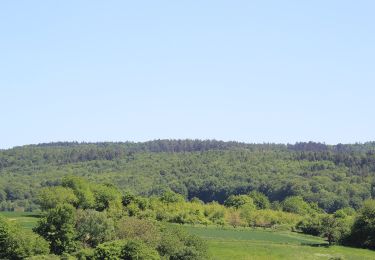
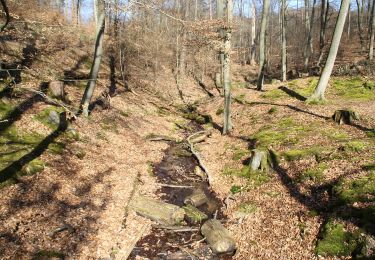
Tocht Te voet van 5,3 km beschikbaar op Hessen, Main-Kinzig-Kreis, Hasselroth. Deze tocht wordt voorgesteld door SityTrail - itinéraires balisés pédestres.
Beschrijving
Trail created by Naturpark Hessischer Spessart.
Hier ist das Symbol mit einem rotem Punkt etwas abgewandelt.
Symbol: Blauer Strich und grüner Bogen über gelbem Rechteck, darunter ein roter Punkt. Das Ganze auf hellblauem Hintergrund.
Plaatsbepaling
Opmerkingen
Wandeltochten in de omgeving
![Tocht Te voet Freigericht - Spessartspuren - Neuseser Fernblick - Photo](https://media.geolcdn.com/t/375/260/ca56fb1d-ddad-4098-9ae7-66f7201cd6d2.jpeg&format=jpg&maxdim=2)
![Te voet Te voet](https://static1.geolcdn.com/sitytour/trail-icons/100.png)
Te voet
![](/images/other/stat-length.png)
![](https://static1.geolcdn.com/siteimages/upload/files/16400158638029165_repeat_loop_refresh_sync_direction_icon.png)
![Tocht Te voet Hanau - Spessartspuren - Niederrodenbach - Barbarossaquelle und Klosterruine - Photo](https://media.geolcdn.com/t/375/260/582999f3-e5b8-4ba5-8b9c-1d0ab3958527.jpeg&format=jpg&maxdim=2)
![Te voet Te voet](https://static1.geolcdn.com/sitytour/trail-icons/100.png)
Te voet
![](/images/other/stat-length.png)
![](https://static1.geolcdn.com/siteimages/upload/files/16400158638029165_repeat_loop_refresh_sync_direction_icon.png)
![Tocht Te voet Hasselroth - Spessartspuren - Niedermittlauer Berkopp Runde - Photo](https://media.geolcdn.com/t/375/260/3e623794-157c-40b8-a2d8-4cb5e8847430.jpeg&format=jpg&maxdim=2)
![Te voet Te voet](https://static1.geolcdn.com/sitytour/trail-icons/100.png)
Te voet
![](/images/other/stat-length.png)
![](https://static1.geolcdn.com/siteimages/upload/files/16400158638029165_repeat_loop_refresh_sync_direction_icon.png)
![Tocht Te voet Freigericht - Spessartspuren - Somborner Hügelland-Spur - Photo](https://media.geolcdn.com/t/375/260/2fd25fb0-9331-491e-9593-ed0fc43d9430.jpeg&format=jpg&maxdim=2)
![Te voet Te voet](https://static1.geolcdn.com/sitytour/trail-icons/100.png)
Te voet
![](/images/other/stat-length.png)
![](https://static1.geolcdn.com/siteimages/upload/files/16400158638029165_repeat_loop_refresh_sync_direction_icon.png)
![Tocht Te voet Rodenbach - Rodenbach - Rundwanderweg Fuchs - Photo](https://media.geolcdn.com/t/375/260/33d9f344-0467-4633-8ac3-2274a87c27a3.jpeg&format=jpg&maxdim=2)
![Te voet Te voet](https://static1.geolcdn.com/sitytour/trail-icons/100.png)
Te voet
![](/images/other/stat-length.png)
![](https://static1.geolcdn.com/siteimages/upload/files/16400158638029165_repeat_loop_refresh_sync_direction_icon.png)
![Tocht Te voet Rodenbach - Spessartbogen Zubringer Niederrodenbach - Burgberg - Photo](https://media.geolcdn.com/t/375/260/7ff6a68d-a567-492a-aadd-6ec4ce0530b1.jpeg&format=jpg&maxdim=2)
![Te voet Te voet](https://static1.geolcdn.com/sitytour/trail-icons/100.png)
Te voet
![](/images/other/stat-length.png)
![](https://static1.geolcdn.com/siteimages/upload/files/16400158638029165_repeat_loop_refresh_sync_direction_icon.png)
![Tocht Te voet Gründau - Kulturweg Gründau-Rothenbergen - Photo](https://media.geolcdn.com/t/375/260/75edf8d9-db50-4ae6-bb8c-0fa7eaa5a2fe.jpeg&format=jpg&maxdim=2)
![Te voet Te voet](https://static1.geolcdn.com/sitytour/trail-icons/100.png)
Te voet
![](/images/other/stat-length.png)
![](https://static1.geolcdn.com/siteimages/upload/files/16400158638029165_repeat_loop_refresh_sync_direction_icon.png)
![Tocht Te voet Hasselroth - Kulturweg Hasselroth - Photo](https://media.geolcdn.com/t/375/260/3e623794-157c-40b8-a2d8-4cb5e8847430.jpeg&format=jpg&maxdim=2)
![Te voet Te voet](https://static1.geolcdn.com/sitytour/trail-icons/100.png)
Te voet
![](/images/other/stat-length.png)
![](https://static1.geolcdn.com/siteimages/upload/files/16400158638029165_repeat_loop_refresh_sync_direction_icon.png)
![Tocht Te voet Freigericht - Kulturweg Birkenhainer Straße 2 - Photo](https://media.geolcdn.com/t/375/260/0c2f9117-57a7-4512-bd7f-99ce7c296dcb.jpeg&format=jpg&maxdim=2)
![Te voet Te voet](https://static1.geolcdn.com/sitytour/trail-icons/100.png)
Te voet
![](/images/other/stat-length.png)
![](https://static1.geolcdn.com/siteimages/upload/files/16400158638029165_repeat_loop_refresh_sync_direction_icon.png)