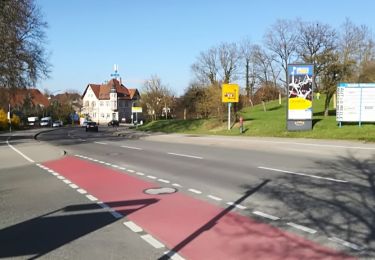
![](/images/other/stat-length.png)
![Tocht Te voet Aach - Hegauer Kegelspiel: Aacher Geißbock - Photo](https://media.geolcdn.com/t/1900/400/8e664d38-f061-4038-b5e7-f7c28cb31e1a.jpeg&format=pjpeg&maxdim=2)
Hegauer Kegelspiel: Aacher Geißbock
SityTrail - itinéraires balisés pédestres
Tous les sentiers balisés d’Europe GUIDE+
![Lengte](/images/other/stat-length.png)
![Max. hoogte](https://static1.geolcdn.com/siteimages/upload/files/1508320355ic_sort_altitude_max_24dp.png)
![Positief hoogteverschil](https://static1.geolcdn.com/siteimages/upload/files/1508320355ic_sort_den_pos_24dp.png)
![Km-Effort](/images/other/stat-length.png)
![Min. hoogte](https://static1.geolcdn.com/siteimages/upload/files/1508320355ic_sort_altitude_min_24dp.png)
![Negatief hoogteverschil](https://static1.geolcdn.com/siteimages/upload/files/1508320355ic_sort_den_neg_24dp.png)
![Boucle](https://static1.geolcdn.com/siteimages/upload/files/16400158638029165_repeat_loop_refresh_sync_direction_icon.png)
![Te voet](https://static1.geolcdn.com/sitytour/trail-icons/100.png)
4h11
Moeilijkheid : Gemakkelijk
![Scan deze QR-code om de tocht te openen in de SityTrail-applicatie](https://capi.geolives.com/qq0zvz2zws4bq2lad0pu/sitytour/trails/3100670/qr.png?size=200)
Gratisgps-wandelapplicatie
Over ons
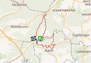
Tocht Te voet van 13,7 km beschikbaar op Baden-Württemberg, Landkreis Konstanz, Aach. Deze tocht wordt voorgesteld door SityTrail - itinéraires balisés pédestres.
Beschrijving
Trail created by Hegau Tourismus e.V..
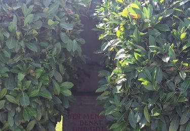
Symbol: stilisierte Hegaugipfel (gelb/blau/pink/grün) auf weißem Grund
Website: https://www.hegau.de/Das_Kegelspiel.280.html
Plaatsbepaling
Opmerkingen
Wandeltochten in de omgeving
![Tocht Te voet Laufen-Uhwiesen - Nohlbrücke - Wehrbrücke Rheinau - Photo](https://media.geolcdn.com/t/375/260/cff12f90-adb2-4075-82f2-1fb0bf9a06a8.jpeg&format=jpg&maxdim=2)
![Te voet Te voet](https://static1.geolcdn.com/sitytour/trail-icons/100.png)
Te voet
![](/images/other/stat-length.png)
![](https://static1.geolcdn.com/siteimages/upload/files/16400158638029165_repeat_loop_refresh_sync_direction_icon.png)
![Tocht Te voet Immendingen - DonauWellen-Premiumweg: Donauversinkung - Photo](https://media.geolcdn.com/t/375/260/7d5a2433-39aa-4f00-a87e-866b6f22ec3d.jpeg&format=jpg&maxdim=2)
![Te voet Te voet](https://static1.geolcdn.com/sitytour/trail-icons/100.png)
Te voet
![](/images/other/stat-length.png)
![](https://static1.geolcdn.com/siteimages/upload/files/16400158638029165_repeat_loop_refresh_sync_direction_icon.png)
![Tocht Te voet Reichenau - Inselrundweg Reichenau - Photo](https://media.geolcdn.com/t/375/260/a596df38-bc5b-4f40-98df-d3032fb97201.jpeg&format=jpg&maxdim=2)
![Te voet Te voet](https://static1.geolcdn.com/sitytour/trail-icons/100.png)
Te voet
![](/images/other/stat-length.png)
![](https://static1.geolcdn.com/siteimages/upload/files/16400158638029165_repeat_loop_refresh_sync_direction_icon.png)
![Tocht Te voet Singen (Hohentwiel) - Singen - Riedöschingen - Photo](https://media.geolcdn.com/t/375/260/27c7ee72-3daa-4a63-8858-c96d1de34635.jpeg&format=jpg&maxdim=2)
![Te voet Te voet](https://static1.geolcdn.com/sitytour/trail-icons/100.png)
Te voet
![](/images/other/stat-length.png)
![](https://static1.geolcdn.com/siteimages/upload/files/16400158638029165_repeat_loop_refresh_sync_direction_icon.png)
![Tocht Te voet Singen (Hohentwiel) - Hegauer Kegelspiel: Albertine-Steig - Photo](https://media.geolcdn.com/t/375/260/c48a83d9-1872-4051-b97c-015bbb6b5cf1.jpeg&format=jpg&maxdim=2)
![Te voet Te voet](https://static1.geolcdn.com/sitytour/trail-icons/100.png)
Te voet
![](/images/other/stat-length.png)
![](https://static1.geolcdn.com/siteimages/upload/files/16400158638029165_repeat_loop_refresh_sync_direction_icon.png)
![Tocht Te voet Gomadingen - Kalter Brunnen - Dreilärchen - Jägerhaus - Photo](https://media.geolcdn.com/t/375/260/19165455-a439-4dd9-ac03-cfb4e801e60a.jpeg&format=jpg&maxdim=2)
![Te voet Te voet](https://static1.geolcdn.com/sitytour/trail-icons/100.png)
Te voet
![](/images/other/stat-length.png)
![](https://static1.geolcdn.com/siteimages/upload/files/16400158638029165_repeat_loop_refresh_sync_direction_icon.png)
![Tocht Te voet Bodman-Ludwigshafen - Wanderweg 29 Bodman - Liggeringen - Photo](https://media.geolcdn.com/t/375/260/e94d9e5e-a0cf-4cfc-a6de-220fa80e3fe6.jpeg&format=jpg&maxdim=2)
![Te voet Te voet](https://static1.geolcdn.com/sitytour/trail-icons/100.png)
Te voet
![](/images/other/stat-length.png)
![](https://static1.geolcdn.com/siteimages/upload/files/16400158638029165_repeat_loop_refresh_sync_direction_icon.png)
![Tocht Fiets Gailingen am Hochrhein - Le lac de Constance de Gailingen à Bodman en passant par Reichenau et Mainau - Photo](https://media.geolcdn.com/t/375/260/ext.jpg?maxdim=2&url=https%3A%2F%2Fservices.sitytrail.com%2FGeolivesWS%2FDownloadMedia.ashx%3FTrailID%3D1000992%26Media%3De7741cbf-9ef1-400f-b0e1-905a4f2d5011.jpg)
![Fiets Fiets](https://static1.geolcdn.com/sitytour/trail-icons/200.png)
Fiets
![](/images/other/stat-length.png)
![](https://static1.geolcdn.com/siteimages/upload/files/16400158638029165_repeat_loop_refresh_sync_direction_icon.png)
![Tocht Te voet Engen - Hewensteig - Photo](https://media.geolcdn.com/t/375/260/ext.jpg?maxdim=2&url=https%3A%2F%2Fstatic1.geolcdn.com%2Fsiteimages%2Fupload%2Ffiles%2F1545311037marcheuse_200dpi.jpg)
![Te voet Te voet](https://static1.geolcdn.com/sitytour/trail-icons/100.png)
Te voet
![](/images/other/stat-length.png)
![](https://static1.geolcdn.com/siteimages/upload/files/16400158638029165_repeat_loop_refresh_sync_direction_icon.png)