![](/images/other/stat-length.png)
![Tocht Te voet Gau-Algesheim - Gau-Algesheim: Rundweg Rabenschule - Photo](https://media.geolcdn.com/t/1900/400/ca85e123-7982-43a9-a7b9-cf5438cdde51.jpeg&format=pjpeg&maxdim=2)
Gau-Algesheim: Rundweg Rabenschule
SityTrail - itinéraires balisés pédestres
Tous les sentiers balisés d’Europe GUIDE+
![Lengte](/images/other/stat-length.png)
![Max. hoogte](https://static1.geolcdn.com/siteimages/upload/files/1508320355ic_sort_altitude_max_24dp.png)
![Positief hoogteverschil](https://static1.geolcdn.com/siteimages/upload/files/1508320355ic_sort_den_pos_24dp.png)
![Km-Effort](/images/other/stat-length.png)
![Min. hoogte](https://static1.geolcdn.com/siteimages/upload/files/1508320355ic_sort_altitude_min_24dp.png)
![Negatief hoogteverschil](https://static1.geolcdn.com/siteimages/upload/files/1508320355ic_sort_den_neg_24dp.png)
![Boucle](https://static1.geolcdn.com/siteimages/upload/files/16400158638029165_repeat_loop_refresh_sync_direction_icon.png)
![Te voet](https://static1.geolcdn.com/sitytour/trail-icons/100.png)
1h06
Moeilijkheid : Gemakkelijk
![Scan deze QR-code om de tocht te openen in de SityTrail-applicatie](https://capi.geolives.com/qq0zvz2zws4bq2lad0pu/sitytour/trails/3099776/qr.png?size=200)
Gratisgps-wandelapplicatie
Over ons
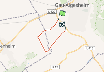
Tocht Te voet van 3,2 km beschikbaar op Rijnland-Palts, Landkreis Mainz-Bingen, Gau-Algesheim. Deze tocht wordt voorgesteld door SityTrail - itinéraires balisés pédestres.
Beschrijving
Symbol: weißes Schild mit schwarzem Rahmen, darin schwarzer, nach links schauender Rabe im Profil, darunter 2-zeilig der Text "Rundweg" und "Rabenschule"
Plaatsbepaling
Opmerkingen
Wandeltochten in de omgeving
![Tocht Te voet Bingen am Rhein - Schönhölle Spelzenberg - Photo](https://media.geolcdn.com/t/375/260/aebd98b5-bd26-4cfe-a768-0233ed14c752.jpeg&format=jpg&maxdim=2)
![Te voet Te voet](https://static1.geolcdn.com/sitytour/trail-icons/100.png)
Te voet
![](/images/other/stat-length.png)
![](https://static1.geolcdn.com/siteimages/upload/files/16400158638029165_repeat_loop_refresh_sync_direction_icon.png)
![Tocht Te voet Ockenheim - Generationenweg - Photo](https://media.geolcdn.com/t/375/260/61dae334-bc68-4664-87ce-cbe8bf1a4704.jpeg&format=jpg&maxdim=2)
![Te voet Te voet](https://static1.geolcdn.com/sitytour/trail-icons/100.png)
Te voet
![](/images/other/stat-length.png)
![](https://static1.geolcdn.com/siteimages/upload/files/16400158638029165_repeat_loop_refresh_sync_direction_icon.png)
![Tocht Te voet Ockenheim - Scharfes Gericht - Photo](https://media.geolcdn.com/t/375/260/61dae334-bc68-4664-87ce-cbe8bf1a4704.jpeg&format=jpg&maxdim=2)
![Te voet Te voet](https://static1.geolcdn.com/sitytour/trail-icons/100.png)
Te voet
![](/images/other/stat-length.png)
![](https://static1.geolcdn.com/siteimages/upload/files/16400158638029165_repeat_loop_refresh_sync_direction_icon.png)
![Tocht Te voet Geisenheim - Geisenheimer Rundweg O - Photo](https://media.geolcdn.com/t/375/260/23caf65e-d1b0-432b-8cb1-95d45052c5b3.jpeg&format=jpg&maxdim=2)
![Te voet Te voet](https://static1.geolcdn.com/sitytour/trail-icons/100.png)
Te voet
![](/images/other/stat-length.png)
![](https://static1.geolcdn.com/siteimages/upload/files/16400158638029165_repeat_loop_refresh_sync_direction_icon.png)
![Tocht Te voet Geisenheim - Geisenheimer Rundweg M - Photo](https://media.geolcdn.com/t/375/260/0aad0740-e5ea-4eab-b9e4-1dc6f9e6e635.jpeg&format=jpg&maxdim=2)
![Te voet Te voet](https://static1.geolcdn.com/sitytour/trail-icons/100.png)
Te voet
![](/images/other/stat-length.png)
![](https://static1.geolcdn.com/siteimages/upload/files/16400158638029165_repeat_loop_refresh_sync_direction_icon.png)
![Tocht Te voet Oestrich-Winkel - Mühlenwanderweg im Elsterbachtal - Photo](https://media.geolcdn.com/t/375/260/e4502c24-35a9-4c74-a651-9299cfecf071.jpeg&format=jpg&maxdim=2)
![Te voet Te voet](https://static1.geolcdn.com/sitytour/trail-icons/100.png)
Te voet
![](/images/other/stat-length.png)
![](https://static1.geolcdn.com/siteimages/upload/files/16400158638029165_repeat_loop_refresh_sync_direction_icon.png)
![Tocht Te voet Geisenheim - Geisenheimer Rundweg L - Photo](https://media.geolcdn.com/t/375/260/f6a6296f-73fa-467e-a544-97556f064c77.jpeg&format=jpg&maxdim=2)
![Te voet Te voet](https://static1.geolcdn.com/sitytour/trail-icons/100.png)
Te voet
![](/images/other/stat-length.png)
![](https://static1.geolcdn.com/siteimages/upload/files/16400158638029165_repeat_loop_refresh_sync_direction_icon.png)
![Tocht Te voet Appenheim - Appenheim: 7-Quellenweg - Photo](https://media.geolcdn.com/t/375/260/ea6e14d4-4768-4e66-812e-25c56d02cbc0.jpeg&format=jpg&maxdim=2)
![Te voet Te voet](https://static1.geolcdn.com/sitytour/trail-icons/100.png)
Te voet
![](/images/other/stat-length.png)
![](https://static1.geolcdn.com/siteimages/upload/files/16400158638029165_repeat_loop_refresh_sync_direction_icon.png)
![Tocht Te voet Geisenheim - Geisenheimer Rundweg K - Photo](https://media.geolcdn.com/t/375/260/1705f1cb-ec9d-4854-8a0d-1320c8a370d7.jpeg&format=jpg&maxdim=2)
![Te voet Te voet](https://static1.geolcdn.com/sitytour/trail-icons/100.png)
Te voet
![](/images/other/stat-length.png)
![](https://static1.geolcdn.com/siteimages/upload/files/16400158638029165_repeat_loop_refresh_sync_direction_icon.png)