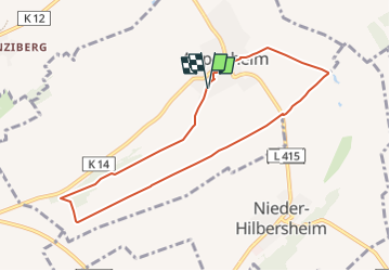
![](/images/other/stat-length.png)
![Tocht Te voet Appenheim - Appenheim: 7-Quellenweg - Photo](https://media.geolcdn.com/t/1900/400/ea6e14d4-4768-4e66-812e-25c56d02cbc0.jpeg&format=pjpeg&maxdim=2)
Appenheim: 7-Quellenweg
SityTrail - itinéraires balisés pédestres
Tous les sentiers balisés d’Europe GUIDE+
![Lengte](/images/other/stat-length.png)
![Max. hoogte](https://static1.geolcdn.com/siteimages/upload/files/1508320355ic_sort_altitude_max_24dp.png)
![Positief hoogteverschil](https://static1.geolcdn.com/siteimages/upload/files/1508320355ic_sort_den_pos_24dp.png)
![Km-Effort](/images/other/stat-length.png)
![Min. hoogte](https://static1.geolcdn.com/siteimages/upload/files/1508320355ic_sort_altitude_min_24dp.png)
![Negatief hoogteverschil](https://static1.geolcdn.com/siteimages/upload/files/1508320355ic_sort_den_neg_24dp.png)
![Boucle](https://static1.geolcdn.com/siteimages/upload/files/16400158638029165_repeat_loop_refresh_sync_direction_icon.png)
![Te voet](https://static1.geolcdn.com/sitytour/trail-icons/100.png)
2h00
Moeilijkheid : Gemakkelijk
![Scan deze QR-code om de tocht te openen in de SityTrail-applicatie](https://capi.geolives.com/qq0zvz2zws4bq2lad0pu/sitytour/trails/3099743/qr.png?size=200)
Gratisgps-wandelapplicatie
Over ons
Tocht Te voet van 7,6 km beschikbaar op Rijnland-Palts, Landkreis Mainz-Bingen, Appenheim. Deze tocht wordt voorgesteld door SityTrail - itinéraires balisés pédestres.
Beschrijving
Symbol: Weißes Schild, daruaf Ziffer 7 in schwarz, umrundet von 7 blauen Punkten, darunter eine blaue, doppelte Wellenlinie. Darunter schwarzer Text: 7-Quellenweg Appenheim.
Plaatsbepaling
Opmerkingen
Wandeltochten in de omgeving
![Tocht Te voet Bingen am Rhein - Schönhölle Spelzenberg - Photo](https://media.geolcdn.com/t/375/260/aebd98b5-bd26-4cfe-a768-0233ed14c752.jpeg&format=jpg&maxdim=2)
![Te voet Te voet](https://static1.geolcdn.com/sitytour/trail-icons/100.png)
Te voet
![](/images/other/stat-length.png)
![](https://static1.geolcdn.com/siteimages/upload/files/16400158638029165_repeat_loop_refresh_sync_direction_icon.png)
![Tocht Te voet Ockenheim - Generationenweg - Photo](https://media.geolcdn.com/t/375/260/61dae334-bc68-4664-87ce-cbe8bf1a4704.jpeg&format=jpg&maxdim=2)
![Te voet Te voet](https://static1.geolcdn.com/sitytour/trail-icons/100.png)
Te voet
![](/images/other/stat-length.png)
![](https://static1.geolcdn.com/siteimages/upload/files/16400158638029165_repeat_loop_refresh_sync_direction_icon.png)
![Tocht Te voet Ockenheim - Scharfes Gericht - Photo](https://media.geolcdn.com/t/375/260/61dae334-bc68-4664-87ce-cbe8bf1a4704.jpeg&format=jpg&maxdim=2)
![Te voet Te voet](https://static1.geolcdn.com/sitytour/trail-icons/100.png)
Te voet
![](/images/other/stat-length.png)
![](https://static1.geolcdn.com/siteimages/upload/files/16400158638029165_repeat_loop_refresh_sync_direction_icon.png)
![Tocht Te voet Gau-Algesheim - Gau-Algesheim: Rundweg Rabenschule - Photo](https://media.geolcdn.com/t/375/260/ca85e123-7982-43a9-a7b9-cf5438cdde51.jpeg&format=jpg&maxdim=2)
![Te voet Te voet](https://static1.geolcdn.com/sitytour/trail-icons/100.png)
Te voet
![](/images/other/stat-length.png)
![](https://static1.geolcdn.com/siteimages/upload/files/16400158638029165_repeat_loop_refresh_sync_direction_icon.png)
![Tocht Te voet Ingelheim am Rhein - Weinmeile - Photo](https://media.geolcdn.com/t/375/260/4accd213-898c-47e0-aedf-5ca5e51d22f5.jpeg&format=jpg&maxdim=2)
![Te voet Te voet](https://static1.geolcdn.com/sitytour/trail-icons/100.png)
Te voet
![](/images/other/stat-length.png)
![](https://static1.geolcdn.com/siteimages/upload/files/16400158638029165_repeat_loop_refresh_sync_direction_icon.png)
![Tocht Te voet Ingelheim am Rhein - Wanderweg Mainzer Berg - Photo](https://media.geolcdn.com/t/375/260/b2dea8bf-12a6-4c90-89f4-3306a67cdad5.jpeg&format=jpg&maxdim=2)
![Te voet Te voet](https://static1.geolcdn.com/sitytour/trail-icons/100.png)
Te voet
![](/images/other/stat-length.png)
![](https://static1.geolcdn.com/siteimages/upload/files/16400158638029165_repeat_loop_refresh_sync_direction_icon.png)
![Tocht Te voet Ingelheim am Rhein - Panoramaweg - Photo](https://media.geolcdn.com/t/375/260/b2dea8bf-12a6-4c90-89f4-3306a67cdad5.jpeg&format=jpg&maxdim=2)
![Te voet Te voet](https://static1.geolcdn.com/sitytour/trail-icons/100.png)
Te voet
![](/images/other/stat-length.png)
![](https://static1.geolcdn.com/siteimages/upload/files/16400158638029165_repeat_loop_refresh_sync_direction_icon.png)
![Tocht Te voet Appenheim - Appenheim: Panoramaweg - Photo](https://media.geolcdn.com/t/375/260/454466a3-386a-45d7-a5e7-da121bcbe225.jpeg&format=jpg&maxdim=2)
![Te voet Te voet](https://static1.geolcdn.com/sitytour/trail-icons/100.png)
Te voet
![](/images/other/stat-length.png)
![](https://static1.geolcdn.com/siteimages/upload/files/16400158638029165_repeat_loop_refresh_sync_direction_icon.png)
![Tocht Te voet Gau-Algesheim - Gau-Algesheim: Dreibächeweg - Photo](https://media.geolcdn.com/t/375/260/9443a4b9-c146-4f82-b83a-f1fe6729c76f.jpeg&format=jpg&maxdim=2)
![Te voet Te voet](https://static1.geolcdn.com/sitytour/trail-icons/100.png)
Te voet
![](/images/other/stat-length.png)
![](https://static1.geolcdn.com/siteimages/upload/files/16400158638029165_repeat_loop_refresh_sync_direction_icon.png)